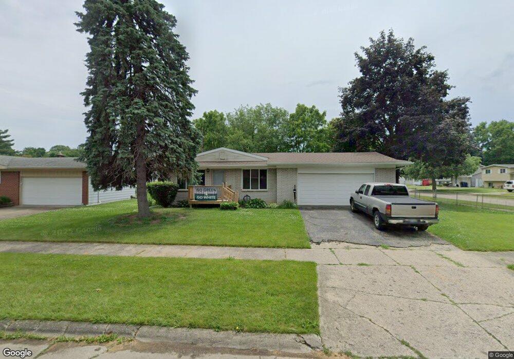
3702 Joal Ln Flint, MI 48506
Potter Longway NeighborhoodEstimated Value: $100,484 - $119,000
2
Beds
2
Baths
1,113
Sq Ft
$100/Sq Ft
Est. Value
About This Home
This home is located at 3702 Joal Ln, Flint, MI 48506 and is currently estimated at $111,121, approximately $99 per square foot. 3702 Joal Ln is a home located in Genesee County with nearby schools including Potter School, Richfield Public School Academy, and Richfield Early Learning Center.
Ownership History
Date
Name
Owned For
Owner Type
Purchase Details
Closed on
Dec 7, 2009
Sold by
Bentley Janet E and Murphy John T
Bought by
Johnson Amanda M
Current Estimated Value
Home Financials for this Owner
Home Financials are based on the most recent Mortgage that was taken out on this home.
Original Mortgage
$44,184
Outstanding Balance
$29,128
Interest Rate
5.11%
Mortgage Type
FHA
Estimated Equity
$81,993
Purchase Details
Closed on
Mar 31, 2008
Sold by
Murphy Alberta J
Bought by
Murphy Alberta J and Murphy James P
Purchase Details
Closed on
Mar 15, 2008
Sold by
Murphy James P and Murphy Mary Margaret
Bought by
Murphy Alberta J
Create a Home Valuation Report for This Property
The Home Valuation Report is an in-depth analysis detailing your home's value as well as a comparison with similar homes in the area
Home Values in the Area
Average Home Value in this Area
Purchase History
| Date | Buyer | Sale Price | Title Company |
|---|---|---|---|
| Johnson Amanda M | $45,000 | Multiple | |
| Murphy Alberta J | -- | None Available | |
| Murphy Alberta J | -- | None Available |
Source: Public Records
Mortgage History
| Date | Status | Borrower | Loan Amount |
|---|---|---|---|
| Open | Johnson Amanda M | $44,184 |
Source: Public Records
Tax History Compared to Growth
Tax History
| Year | Tax Paid | Tax Assessment Tax Assessment Total Assessment is a certain percentage of the fair market value that is determined by local assessors to be the total taxable value of land and additions on the property. | Land | Improvement |
|---|---|---|---|---|
| 2025 | $1,147 | $46,400 | $0 | $0 |
| 2024 | $1,034 | $37,900 | $0 | $0 |
| 2023 | $1,012 | $31,700 | $0 | $0 |
| 2022 | $0 | $24,500 | $0 | $0 |
| 2021 | $1,056 | $22,600 | $0 | $0 |
| 2020 | $947 | $20,100 | $0 | $0 |
| 2019 | $919 | $20,100 | $0 | $0 |
| 2018 | $931 | $17,000 | $0 | $0 |
| 2017 | $903 | $0 | $0 | $0 |
| 2016 | $897 | $0 | $0 | $0 |
| 2015 | -- | $0 | $0 | $0 |
| 2014 | -- | $0 | $0 | $0 |
| 2012 | -- | $19,700 | $0 | $0 |
Source: Public Records
Map
Nearby Homes
- 3729 Craig Dr
- 00 Richfield Rd
- 3301 N Center Rd
- 3226 Mcclure Ave
- 3200 N Averill Ave
- 3088 Layman Dr
- 3250 Carr St
- 3602 Dakota Ave
- 3710 Branch Rd
- 3702 Branch Rd
- 3301 S Kearsley Blvd
- 3809 Delaware Ave
- 3010 Wyoming Ave
- 4127 Coggins Ave
- 3045 Covert Rd
- 2446 Lanning Dr
- 3713 Risedorph Ave
- 3214 Maryland Ave
- 2935 Richfield Rd
- 4101 Sugar Maple Run Unit 1