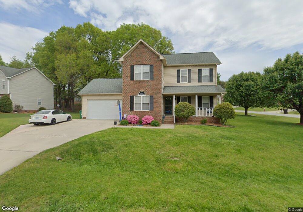
3707 Pointer Ct High Point, NC 27265
Deep River NeighborhoodEstimated Value: $279,990 - $342,000
3
Beds
3
Baths
1,714
Sq Ft
$186/Sq Ft
Est. Value
About This Home
This home is located at 3707 Pointer Ct, High Point, NC 27265 and is currently estimated at $318,748, approximately $185 per square foot. 3707 Pointer Ct is a home located in Guilford County with nearby schools including Southwest Elementary School, Welborn Academy of Science & Technology, and T.W. Andrews High School.
Ownership History
Date
Name
Owned For
Owner Type
Purchase Details
Closed on
Oct 21, 2010
Sold by
Cornish Douglas J and Cornish Christine M
Bought by
Ciociola Kara
Current Estimated Value
Home Financials for this Owner
Home Financials are based on the most recent Mortgage that was taken out on this home.
Original Mortgage
$15,400
Outstanding Balance
$10,212
Interest Rate
4.37%
Mortgage Type
Credit Line Revolving
Estimated Equity
$308,536
Purchase Details
Closed on
Jul 29, 2005
Sold by
Holland Calvin Scott and Holland Nikki R
Bought by
Cornish Douglas J and Cornish Christine M
Home Financials for this Owner
Home Financials are based on the most recent Mortgage that was taken out on this home.
Original Mortgage
$156,000
Interest Rate
5.59%
Mortgage Type
Fannie Mae Freddie Mac
Create a Home Valuation Report for This Property
The Home Valuation Report is an in-depth analysis detailing your home's value as well as a comparison with similar homes in the area
Home Values in the Area
Average Home Value in this Area
Purchase History
| Date | Buyer | Sale Price | Title Company |
|---|---|---|---|
| Ciociola Kara | $155,000 | None Available | |
| Cornish Douglas J | $156,000 | None Available |
Source: Public Records
Mortgage History
| Date | Status | Borrower | Loan Amount |
|---|---|---|---|
| Open | Ciociola Kara | $15,400 | |
| Open | Ciociola Kara | $123,920 | |
| Previous Owner | Cornish Douglas J | $156,000 |
Source: Public Records
Tax History
| Year | Tax Paid | Tax Assessment Tax Assessment Total Assessment is a certain percentage of the fair market value that is determined by local assessors to be the total taxable value of land and additions on the property. | Land | Improvement |
|---|---|---|---|---|
| 2025 | $2,308 | $167,500 | $38,000 | $129,500 |
| 2024 | $2,308 | $167,500 | $38,000 | $129,500 |
| 2023 | $2,308 | $167,500 | $38,000 | $129,500 |
| 2022 | $2,258 | $167,500 | $38,000 | $129,500 |
| 2021 | $2,093 | $151,900 | $35,000 | $116,900 |
| 2020 | $2,093 | $151,900 | $35,000 | $116,900 |
| 2019 | $2,093 | $151,900 | $0 | $0 |
| 2018 | $2,083 | $151,900 | $0 | $0 |
| 2017 | $2,093 | $151,900 | $0 | $0 |
| 2016 | $2,126 | $151,600 | $0 | $0 |
| 2015 | $2,138 | $151,600 | $0 | $0 |
| 2014 | $2,174 | $151,600 | $0 | $0 |
Source: Public Records
Map
Nearby Homes
- 4126 Birchgarden Dr
- 4210 Birch Dr
- 4404 Essex Ct
- 1517 Skeet Club Rd
- 1515 Skeet Club Rd
- 3912 Wynne Brook Ct
- 3905 Wynne Brook Ct
- 3924 Braddock Rd
- 3421 Wildwood Ave
- 3650 Single Leaf Ct
- 4008 Deerfield St
- 3696 Waterford Oak Ct
- 4218 Pelican St
- 940 Bloomington Way
- 4518 Oak Hollow Dr
- 4004 Baywater Point
- 3869 Hickswood Creek Dr
- 4323 Holstein Dr
- 2116 Penny Rd
- 3023 Maple Branch Dr
- 4117 Birchgarden Dr
- 3703 Pointer Ct
- 3706 Pointer Ct
- 4116 Birchgarden Dr
- 4121 Birchgarden Dr
- 3700 Pointer Ct
- 4118 Birchgarden Dr
- 3701 Pointer Ct
- 4120 Birchgarden Dr
- 3704 Quail Marsh Ct
- 4107 Birchgarden Dr
- 4008 Red Oak Ct
- 3702 Quail Marsh Ct
- 3706 Quail Marsh Ct
- 4122 Birchgarden Dr
- 4006 Red Oak Ct
- 4007 Red Oak Ct
- 4104 Birchgarden Dr
- 4105 Birchgarden Dr
- 3700 Quail Marsh Ct
Your Personal Tour Guide
Ask me questions while you tour the home.