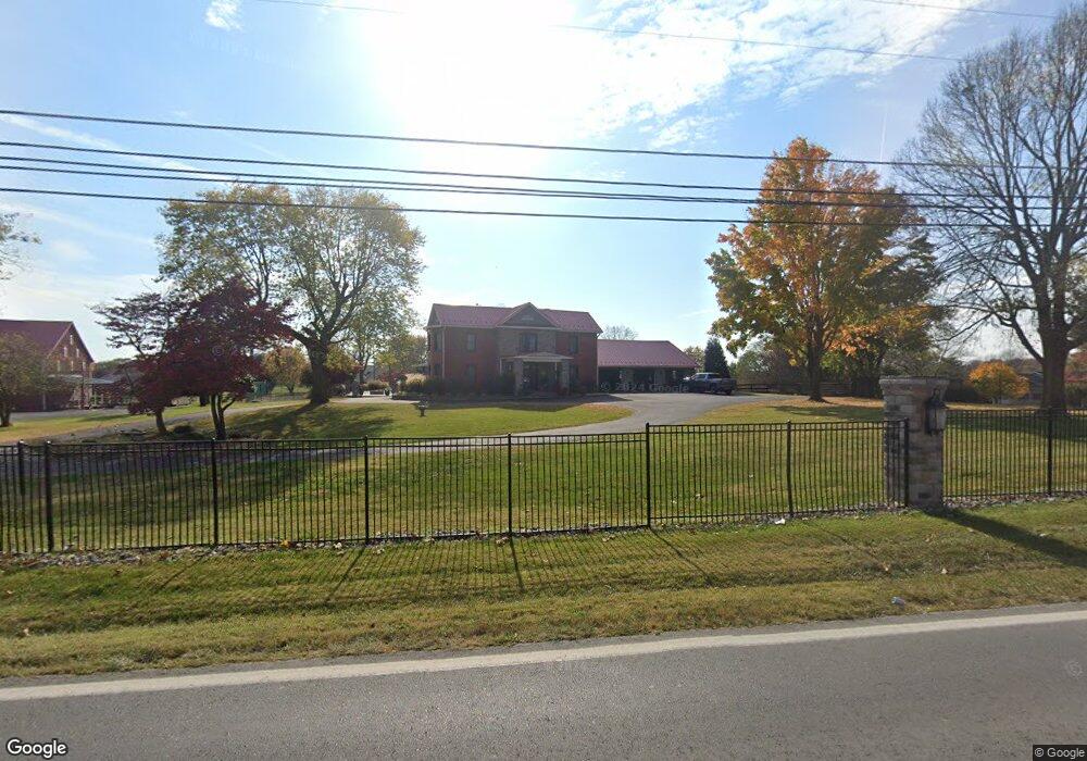
3708 Old Leetown Pike Ranson, WV 25438
Estimated Value: $506,000 - $734,165
3
Beds
3
Baths
3,748
Sq Ft
$167/Sq Ft
Est. Value
About This Home
This home is located at 3708 Old Leetown Pike, Ranson, WV 25438 and is currently estimated at $624,541, approximately $166 per square foot. 3708 Old Leetown Pike is a home located in Jefferson County with nearby schools including T.A. Lowery Elementary School, Wildwood Middle School, and Jefferson High School.
Ownership History
Date
Name
Owned For
Owner Type
Purchase Details
Closed on
May 4, 2007
Sold by
Fargo Dominick and Fargo Margie F
Bought by
Fargo J Frank
Current Estimated Value
Home Financials for this Owner
Home Financials are based on the most recent Mortgage that was taken out on this home.
Original Mortgage
$400,000
Outstanding Balance
$248,540
Interest Rate
6.75%
Mortgage Type
Adjustable Rate Mortgage/ARM
Estimated Equity
$376,001
Create a Home Valuation Report for This Property
The Home Valuation Report is an in-depth analysis detailing your home's value as well as a comparison with similar homes in the area
Home Values in the Area
Average Home Value in this Area
Purchase History
| Date | Buyer | Sale Price | Title Company |
|---|---|---|---|
| Fargo J Frank | $400,000 | None Available |
Source: Public Records
Mortgage History
| Date | Status | Borrower | Loan Amount |
|---|---|---|---|
| Open | Fargo J Frank | $400,000 |
Source: Public Records
Tax History Compared to Growth
Tax History
| Year | Tax Paid | Tax Assessment Tax Assessment Total Assessment is a certain percentage of the fair market value that is determined by local assessors to be the total taxable value of land and additions on the property. | Land | Improvement |
|---|---|---|---|---|
| 2025 | $4,467 | $384,400 | $85,200 | $299,200 |
| 2024 | $4,217 | $360,200 | $85,200 | $275,000 |
| 2023 | $4,207 | $360,200 | $85,200 | $275,000 |
| 2022 | $3,846 | $322,800 | $80,200 | $242,600 |
| 2021 | $3,520 | $289,800 | $75,100 | $214,700 |
| 2020 | $3,291 | $289,200 | $72,200 | $217,000 |
| 2019 | $3,344 | $288,400 | $69,200 | $219,200 |
| 2018 | $3,269 | $278,300 | $66,700 | $211,600 |
| 2017 | $3,228 | $274,800 | $61,000 | $213,800 |
| 2016 | $3,302 | $281,900 | $67,900 | $214,000 |
| 2015 | $3,188 | $270,700 | $67,900 | $202,800 |
| 2014 | $2,618 | $222,700 | $52,400 | $170,300 |
Source: Public Records
Map
Nearby Homes
- 0 Lot 427 Gerry St Unit WVJF2020406
- 122 Thornton Ave
- 1 Braxton Ave
- 0 Braxton Ave
- 106 Thornton Ave
- 114 Thornton Ave
- 103 Thornton Ave
- 79 Thornton Ave
- 94 Thornton Ave
- Homesite 211 Sherman Ave
- 319 Gerry St
- Homesite 458 Sherman Ave
- Homesite 377 Sherman Ave
- Homesite 499 Sherman Ave
- 26 Sherman Ave
- 226 Huntwell West Ave
- 10 Sherman Ave
- 225 Huntwell West Ave
- 221 Huntwell West Ave
- 184 Huntwell Blvd W
- 3688 Old Leetown Pike
- 126 Lone Oak Rd
- 63 Alexis Dr
- 3624 Old Leetown Pike
- 3587 Old Leetown Pike
- 48 Lone Oak Rd
- 3579 Old Leetown Pike
- 113 Alexis Dr
- 3594 Old Leetown Pike
- 0 Old Leetown Pike Unit 1006441192
- 0 Old Leetown Pike Unit 1006440866
- 3817 Old Leetown Pike
- 3643 Old Leetown Pike
- 121 Lone Oak Rd
- 69 Lone Oak Rd
- 32 Cabinetmaker Ln
- 2 Cabinetmaker Ln
- 188 Lone Oak Rd
- 191 Alexis Dr
- 191 Alexis Dr