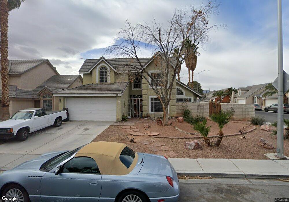
3709 Dalecrest Dr Las Vegas, NV 89129
Lone Mountain NeighborhoodEstimated Value: $459,000 - $516,000
3
Beds
3
Baths
2,000
Sq Ft
$245/Sq Ft
Est. Value
About This Home
This home is located at 3709 Dalecrest Dr, Las Vegas, NV 89129 and is currently estimated at $490,835, approximately $245 per square foot. 3709 Dalecrest Dr is a home located in Clark County with nearby schools including Marc Kahre Elementary School, Dorothy Eisenberg Elementary School, and Irwin & Susan Molasky Junior High School.
Ownership History
Date
Name
Owned For
Owner Type
Purchase Details
Closed on
Jan 27, 1997
Sold by
Daniels Edward Anthony
Bought by
Daniels Edward A and Daniels Suazo Living Trust
Current Estimated Value
Purchase Details
Closed on
Oct 18, 1993
Sold by
Wier Chet S
Bought by
Daniels Edward Anthony
Create a Home Valuation Report for This Property
The Home Valuation Report is an in-depth analysis detailing your home's value as well as a comparison with similar homes in the area
Home Values in the Area
Average Home Value in this Area
Purchase History
| Date | Buyer | Sale Price | Title Company |
|---|---|---|---|
| Daniels Edward A | -- | -- | |
| Daniels Edward Anthony | $138,000 | Stewart Title |
Source: Public Records
Tax History Compared to Growth
Tax History
| Year | Tax Paid | Tax Assessment Tax Assessment Total Assessment is a certain percentage of the fair market value that is determined by local assessors to be the total taxable value of land and additions on the property. | Land | Improvement |
|---|---|---|---|---|
| 2025 | $2,050 | $97,170 | $36,750 | $60,420 |
| 2024 | $1,991 | $97,170 | $36,750 | $60,420 |
| 2023 | $1,991 | $99,719 | $41,650 | $58,069 |
| 2022 | $2,119 | $83,270 | $29,400 | $53,870 |
| 2021 | $1,962 | $78,631 | $26,950 | $51,681 |
| 2020 | $1,819 | $76,880 | $25,200 | $51,680 |
| 2019 | $1,705 | $73,569 | $22,400 | $51,169 |
| 2018 | $1,627 | $72,014 | $22,400 | $49,614 |
| 2017 | $2,363 | $72,087 | $21,350 | $50,737 |
| 2016 | $1,523 | $63,202 | $11,900 | $51,302 |
| 2015 | $1,520 | $51,982 | $11,550 | $40,432 |
| 2014 | $1,475 | $43,938 | $8,750 | $35,188 |
Source: Public Records
Map
Nearby Homes
- 3660 Renovah St Unit 104
- 3660 Renovah St Unit 202
- 7061 Roscoe Ave Unit 101
- 7125 Caprock Cir
- 3600 Depew Cir
- 3600 Monarcas St Unit 202
- 3608 Lisandro St Unit 104
- 3508 N Tenaya Way
- 3740 Broadriver Dr
- 3609 Galatea St Unit 102
- 3609 Pintadas St Unit 202
- 6809 Cobre Azul Ave Unit 202
- 6917 Raleigh Ave
- 3436 N Tenaya Way
- 6808 Elm Creek Dr Unit 203
- 6808 Elm Creek Dr Unit 104
- 3601 Spanish Butterfly St Unit 202
- 6800 Elm Creek Dr Unit 103
- 3813 Marshall Cir
- 6700 Amarinta Ave Unit 103
- 3705 Dalecrest Dr
- 7105 Maybrook Dr
- 7100 Maybrook Dr
- 3701 Dalecrest Dr
- 7104 Deepriver Cir
- 7104 Maybrook Dr
- 7109 Maybrook Dr
- 7108 Maybrook Dr
- 7108 Deepriver Cir
- 7113 Maybrook Dr
- 7112 Maybrook Dr
- 7101 Lagoon Landing Dr
- 7112 Deepriver Cir
- 7105 Lagoon Landing Dr
- 7109 Lagoon Landing Dr
- 7109 W Lagoon Landing Dr
- 7101 Deepriver Cir
- 7117 Maybrook Dr
- 7105 Deepriver Cir
- 7116 Maybrook Dr Unit 1