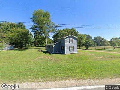
3711 Riverside Rd Benton Harbor, MI 49022
Estimated Value: $118,872 - $211,000
3
Beds
1
Bath
824
Sq Ft
$196/Sq Ft
Est. Value
About This Home
This home is located at 3711 Riverside Rd, Benton Harbor, MI 49022 and is currently estimated at $161,718, approximately $196 per square foot. 3711 Riverside Rd is a home located in Berrien County.
Ownership History
Date
Name
Owned For
Owner Type
Purchase Details
Closed on
Jun 17, 2024
Sold by
Mammina Vincent John
Bought by
Berrien County Treasurer
Current Estimated Value
Purchase Details
Closed on
Aug 23, 2019
Sold by
Ward Joanna Lynn
Bought by
Mammina Vincent John
Purchase Details
Closed on
Nov 15, 2016
Sold by
Kozi Properties Llc
Bought by
Ward Joanna Lynn
Purchase Details
Closed on
Jul 11, 2001
Purchase Details
Closed on
Aug 2, 1982
Purchase Details
Closed on
Jun 5, 1981
Create a Home Valuation Report for This Property
The Home Valuation Report is an in-depth analysis detailing your home's value as well as a comparison with similar homes in the area
Home Values in the Area
Average Home Value in this Area
Purchase History
| Date | Buyer | Sale Price | Title Company |
|---|---|---|---|
| Berrien County Treasurer | -- | -- | |
| Mammina Vincent John | -- | None Available | |
| Ward Joanna Lynn | -- | Attorney | |
| -- | -- | -- | |
| -- | $11,000 | -- | |
| -- | $7,000 | -- |
Source: Public Records
Mortgage History
| Date | Status | Borrower | Loan Amount |
|---|---|---|---|
| Previous Owner | Mammina Vincent John | $20,000 |
Source: Public Records
Tax History Compared to Growth
Tax History
| Year | Tax Paid | Tax Assessment Tax Assessment Total Assessment is a certain percentage of the fair market value that is determined by local assessors to be the total taxable value of land and additions on the property. | Land | Improvement |
|---|---|---|---|---|
| 2025 | $1,211 | $58,000 | $0 | $0 |
| 2024 | $350 | $43,700 | $0 | $0 |
| 2023 | $334 | $37,000 | $0 | $0 |
| 2022 | $318 | $32,900 | $0 | $0 |
| 2021 | $1,060 | $31,400 | $3,700 | $27,700 |
| 2020 | $1,031 | $27,900 | $0 | $0 |
| 2019 | $855 | $27,500 | $0 | $0 |
| 2018 | $835 | $24,300 | $0 | $0 |
| 2017 | $818 | $22,000 | $0 | $0 |
| 2016 | $1,035 | $27,900 | $0 | $0 |
| 2015 | $783 | $21,400 | $0 | $0 |
| 2014 | $227 | $20,900 | $0 | $0 |
Source: Public Records
Map
Nearby Homes
- o Riverside Rd
- 3987 Fikes Rd
- 0 Fikes Rd
- 3350 Riverside Rd
- 4380 Fikes Rd
- 77.99+/-acres Coloma Rd
- 2059 Lynch Rd
- 3694 Kerlikowske Rd
- 0 Peachtree Ln Unit 25024977
- 2887 Coloma Rd
- 3271 Kerlikowske Rd
- 4890 Michigan 63
- 2759 Riverside Rd
- 4928 Pier Rd
- 2745 Riverside Rd
- 5068 Pier Rd
- 3079 Pershing Dr
- 3080 Pershing Dr
- 5212 Pier Rd
- 3089 Dogwood St
- 3711 Riverside Rd
- 4940 Riverside Rd
- 3727 Riverside Rd
- 3736 Riverside Rd
- 3722 Riverside Rd
- 3724 Riverside Rd
- 3688 Riverside Rd
- 3149 N Chabot Rd
- 3149 Chabot Rd
- 3149 N Chabot Rd
- 3767 Riverside Rd
- 3666 Riverside Rd
- 0 N Chabot Rd
- 3778 Riverside Rd
- 3770 Riverside Rd
- 3645 Riverside Rd
- 3421 Riverside Rd
- 0 Riverside Rd
- 3652 Riverside Rd
- 3794 Riverside Rd