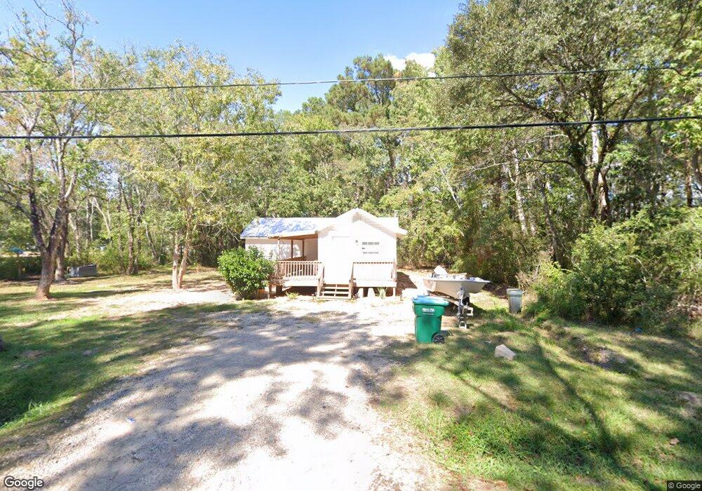
3717 Avon Ave Moss Point, MS 39563
Estimated Value: $70,035 - $120,000
Studio
1
Bath
840
Sq Ft
$117/Sq Ft
Est. Value
About This Home
This home is located at 3717 Avon Ave, Moss Point, MS 39563 and is currently estimated at $98,259, approximately $116 per square foot. 3717 Avon Ave is a home located in Jackson County with nearby schools including Kreole Primary Elementary School, Escatawpa Upper Elementary School, and Magnolia Middle School.
Ownership History
Date
Name
Owned For
Owner Type
Purchase Details
Closed on
Jan 24, 2025
Sold by
Cronier Gregory S
Bought by
Lake Joshua
Current Estimated Value
Home Financials for this Owner
Home Financials are based on the most recent Mortgage that was taken out on this home.
Original Mortgage
$100,150
Outstanding Balance
$96,215
Interest Rate
5.84%
Mortgage Type
Seller Take Back
Estimated Equity
$2,044
Create a Home Valuation Report for This Property
The Home Valuation Report is an in-depth analysis detailing your home's value as well as a comparison with similar homes in the area
Home Values in the Area
Average Home Value in this Area
Purchase History
| Date | Buyer | Sale Price | Title Company |
|---|---|---|---|
| Lake Joshua | -- | Island Winds Title | |
| Lake Joshua | -- | Island Winds Title |
Source: Public Records
Mortgage History
| Date | Status | Borrower | Loan Amount |
|---|---|---|---|
| Open | Lake Joshua | $100,150 | |
| Closed | Lake Joshua | $100,150 |
Source: Public Records
Tax History
| Year | Tax Paid | Tax Assessment Tax Assessment Total Assessment is a certain percentage of the fair market value that is determined by local assessors to be the total taxable value of land and additions on the property. | Land | Improvement |
|---|---|---|---|---|
| 2025 | $552 | $3,214 | $812 | $2,402 |
| 2024 | $552 | $2,757 | $785 | $1,972 |
| 2023 | $473 | $2,557 | $785 | $1,772 |
| 2022 | $417 | $2,556 | $0 | $0 |
| 2021 | $422 | $2,586 | $0 | $0 |
| 2020 | $404 | $2,451 | $873 | $1,578 |
| 2019 | $403 | $2,451 | $873 | $1,578 |
| 2018 | $403 | $2,451 | $873 | $1,578 |
| 2017 | $401 | $2,451 | $873 | $1,578 |
| 2016 | $126 | $2,451 | $873 | $1,578 |
| 2015 | $131 | $17,050 | $5,820 | $11,230 |
| 2014 | $131 | $2,558 | $873 | $1,685 |
| 2013 | $131 | $2,558 | $873 | $1,685 |
Source: Public Records
Map
Nearby Homes
- 3712 Dale Ln
- 0 Downing Ave
- 7621 Elder Ferry Rd
- 0 Hwy 613 Hwy Unit 4127039
- 0 Hwy 613 Hwy Unit 4137821
- 0 Hwy 613 Hwy Unit 4129036
- 6924 Barnes Rd
- 6908 Barnes Rd
- 4113 Mimosa Dr
- 8304 Austeria St
- 7208 Elder Ferry Rd
- 4319 Adcock St
- 4221 Knowles Ave
- 0 Tanner St Unit 4134049
- 0 Tanner St Unit 4134051
- 7016 Elder Ferry Rd
- 3700 Cochran Ave
- 8629 Mississippi 613
- 4316 Knowlcrest Dr
- 0 Interstate 10
- 000 Britt Ave
- 3722 Avon Ave
- 3700 Britt Ave
- 3729 Avon Ave
- 3728 Britt Ave
- 7616 Brookshire St
- 3717 Britt Ave
- 7505 Barnes Rd
- 3705 Avon Ave
- 7620 Brookshire St
- 3729 Britt Ave
- 3801 Dearman Ave
- 7504 Barnes Rd
- 3704 Brohum Ave
- 3716 Brohum Ave
- 3728 Brohum Ave
- 3801 Regent Ave
- 3804 Dearman Ave
- 3805 Regent Ave
- 3709 Brohum Ave
Your Personal Tour Guide
Ask me questions while you tour the home.