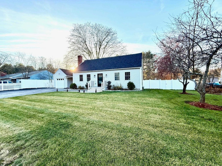
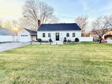
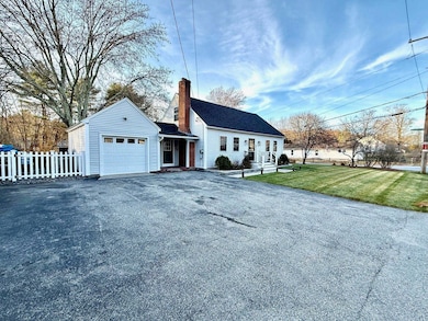
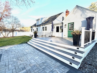
375 Main Dunstable Rd Nashua, NH 03062
West Hollis NeighborhoodEstimated payment $3,819/month
Highlights
- Very Popular Property
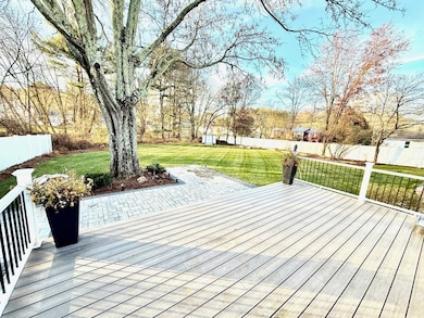
- Deck
- Fireplace
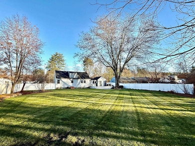
- Cape Cod Architecture
- Wood Flooring
- Patio
About This Home
Stunning 2022 Full Gut Renovation – Move-In Ready!
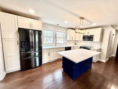
This home sitting on over a 1/2 acre, was taken down to the studs and completely renovated in 2022 with all new: Roof, windows, doors, hardwood flooring throughout the first floor, stylish kitchen with quartz counters, black stainless appliances and soft close cabinets, two fully upgraded bathrooms. Additional features include: first floor primary bedroom, cozy wood burning fire place, High-efficiency HVAC & power vent hot water, new electrical service, trex deck, patio, privacy fencing, professional landscaping, and full irrigation system. Agent interest. Delayed showings Start 12/6 at 10:30am

Home Details
Home Type
- Single Family
Est. Annual Taxes
- $8,050
Year Built
- Built in 1958
Parking
- 1 Car Garage
Home Design
- Cape Cod Architecture
- Concrete Foundation
- Wood Frame Construction
- Vinyl Siding
Interior Spaces
- Property has 2 Levels
- Fireplace
- Basement
- Walk-Up Access
Kitchen
- Microwave
- Dishwasher
- Disposal
Flooring
- Wood
- Carpet
- Tile
Bedrooms and Bathrooms
- 3 Bedrooms
Laundry
- Dryer
- Washer
Outdoor Features
- Deck
- Patio
Schools
- Main Dunstable Elementary Sch
- Nashua High School South
Additional Features
- 0.52 Acre Lot
- City Lot
- Forced Air Heating and Cooling System
Map
Home Values in the Area
Average Home Value in this Area
Tax History
| Year | Tax Paid | Tax Assessment Tax Assessment Total Assessment is a certain percentage of the fair market value that is determined by local assessors to be the total taxable value of land and additions on the property. | Land | Improvement |
|---|---|---|---|---|
| 2024 | $8,050 | $506,300 | $165,900 | $340,400 |
| 2023 | $7,580 | $415,800 | $132,700 | $283,100 |
| 2022 | $7,138 | $395,000 | $132,700 | $262,300 |
| 2021 | $5,870 | $252,800 | $88,500 | $164,300 |
| 2020 | $5,698 | $252,000 | $88,500 | $163,500 |
| 2019 | $5,484 | $252,000 | $88,500 | $163,500 |
| 2018 | $5,345 | $252,000 | $88,500 | $163,500 |
| 2017 | $5,199 | $201,600 | $77,100 | $124,500 |
| 2016 | $5,054 | $201,600 | $77,100 | $124,500 |
| 2015 | $4,945 | $201,600 | $77,100 | $124,500 |
| 2014 | $4,930 | $205,000 | $77,100 | $127,900 |
Property History
| Date | Event | Price | List to Sale | Price per Sq Ft |
|---|---|---|---|---|
| 12/02/2025 12/02/25 | For Sale | $599,000 | -- | $445 / Sq Ft |
Purchase History
| Date | Type | Sale Price | Title Company |
|---|---|---|---|
| Warranty Deed | $210,000 | None Available | |
| Deed | $4,000 | -- |
Mortgage History
| Date | Status | Loan Amount | Loan Type |
|---|---|---|---|
| Open | $288,000 | Purchase Money Mortgage | |
| Previous Owner | $337,500 | Stand Alone Refi Refinance Of Original Loan | |
| Previous Owner | $199,750 | Unknown | |
| Previous Owner | $192,000 | Unknown |
Source: PrimeMLS
MLS Number: 5071016
APN: NASH-000000-000000-000158C
Disclaimer: Certain information contained herein is derived from information provided by parties other than Homes.com. All information provided is deemed reliable, but is not guaranteed to be accurate and should be independently verified.
![]() Copyright 2025 PrimeMLS, Inc. All rights reserved. This information is deemed reliable, but not guaranteed. The data relating to real estate displayed on this display comes in part from the IDX Program of PrimeMLS. The information being provided is for consumers’ personal, non-commercial use and may not be used for any purpose other than to identify prospective properties consumers may be interested in purchasing.
Copyright 2025 PrimeMLS, Inc. All rights reserved. This information is deemed reliable, but not guaranteed. The data relating to real estate displayed on this display comes in part from the IDX Program of PrimeMLS. The information being provided is for consumers’ personal, non-commercial use and may not be used for any purpose other than to identify prospective properties consumers may be interested in purchasing.
- 9 Michelle Dr
- 25 Cortez Dr Unit U57
- 16 Laurel Ct Unit U320
- 5 Wilderness Dr
- 47 Dogwood Dr Unit U202
- 4 Henry David Dr Unit 203
- 15 Westray Dr
- 12 Spring Cove Rd Unit U103
- 40 Spring Cove Rd Unit U117
- 30 Gendron St
- 300 Candlewood Park Unit 336
- 42 Woodfield St
- 23 Glen Dr
- 8 Althea Ln Unit U26
- 2 Wakefield Dr
- 599 W Hollis St
- 247 Main Dunstable Rd
- 11 Norma Dr Unit U30
- 20 Martha St
- 23 Parkhurst Dr
- 26 Pittsburgh Dr
- 53 Congress St
- 10 Barrington Ave Unit U107
- 28 Nagle St
- 65 Georgetown Dr
- 122 Coliseum Ave Unit 201
- 139 W Hollis St Unit 3
- 32 Gilman St
- 3 Perry Ave
- 8 Newton Dr
- 8 Digital Dr
- 1 Storage Dr
- 73 Kinsley St Unit B
- 101 W Hollis St Unit 1
- 101 W Hollis St Unit 2
- 177 Chestnut St
- 96 Palm St
- 57 Palm St
- 105 Chestnut St Unit 1
- 3 Oak Hill Ln