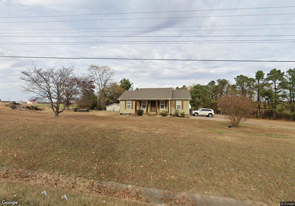
3751 Us Highway 70 E Brownsville, TN 38012
Estimated Value: $155,000 - $206,000
--
Bed
2
Baths
1,680
Sq Ft
$107/Sq Ft
Est. Value
About This Home
This home is located at 3751 Us Highway 70 E, Brownsville, TN 38012 and is currently estimated at $179,424, approximately $106 per square foot. 3751 Us Highway 70 E is a home located in Haywood County with nearby schools including Anderson Early Childhood Center, East Side Elementary School, and Haywood Elementary School.
Ownership History
Date
Name
Owned For
Owner Type
Purchase Details
Closed on
Jul 30, 2004
Sold by
Vance Crook William
Bought by
Perez Arellanes Rufina
Current Estimated Value
Purchase Details
Closed on
Mar 23, 1999
Sold by
Lee Turner Roy
Bought by
Crook William V
Purchase Details
Closed on
May 19, 1998
Sold by
Joe Matheny Michael
Bought by
Lee Turner Roy
Purchase Details
Closed on
Mar 29, 1984
Bought by
Matheny Michael Joe and Rita Jean
Purchase Details
Closed on
Jan 1, 1984
Create a Home Valuation Report for This Property
The Home Valuation Report is an in-depth analysis detailing your home's value as well as a comparison with similar homes in the area
Home Values in the Area
Average Home Value in this Area
Purchase History
| Date | Buyer | Sale Price | Title Company |
|---|---|---|---|
| Perez Arellanes Rufina | $84,000 | -- | |
| Crook William V | $76,500 | -- | |
| Lee Turner Roy | $79,000 | -- | |
| Matheny Michael Joe | -- | -- | |
| -- | $6,500 | -- |
Source: Public Records
Tax History Compared to Growth
Tax History
| Year | Tax Paid | Tax Assessment Tax Assessment Total Assessment is a certain percentage of the fair market value that is determined by local assessors to be the total taxable value of land and additions on the property. | Land | Improvement |
|---|---|---|---|---|
| 2025 | $884 | $45,825 | $0 | $0 |
| 2024 | $884 | $45,825 | $5,550 | $40,275 |
| 2023 | $682 | $24,725 | $4,250 | $20,475 |
| 2022 | $682 | $24,725 | $4,250 | $20,475 |
| 2021 | $682 | $24,725 | $4,250 | $20,475 |
| 2020 | $511 | $24,375 | $4,250 | $20,125 |
| 2019 | $511 | $24,375 | $4,250 | $20,125 |
| 2018 | $525 | $18,250 | $3,725 | $14,525 |
| 2017 | $525 | $18,250 | $3,725 | $14,525 |
| 2016 | $484 | $18,250 | $3,725 | $14,525 |
| 2015 | $437 | $18,250 | $3,725 | $14,525 |
| 2014 | $437 | $18,250 | $3,725 | $14,525 |
Source: Public Records
Map
Nearby Homes
- 135 Davis Rd
- 855 Springfield Rd
- 77 Upper Zion Rd
- 1450 Friendship Rd
- 0 Deerfield Cove Unit 2504512
- 2902 Us Highway 79 N
- 00 Route 76
- 2397 U S 79
- 470 Marbury Rd
- 1114 Warren St
- 1295 Anderson Ave
- 917 Anderson Ave Unit A
- 930 Gray St
- 703 Cottonwood Dr
- 2267 Anderson Ave
- 105 N Bond Ave
- 411 N Bond Ave
- 5596 79 Hwy N
- 1342 Watkins St
- 833 Hatchie St
- 3851 Us Highway 70 E
- 3889 Us Highway 70 E
- 3919 Us Highway 70 E
- 3599 Us Highway 70 E
- 3935 Us Highway 70 E
- 4169 Us Highway 70 E
- 3486 Us Highway 70 E
- 91 Springfield Rd
- 4110 Us Highway 70 E
- 108 Cox Ln
- 4168 Us Highway 70 E
- 32 Cox Ln
- 0 Cox Ln
- 148 Cox Ln
- 190 Cox Ln
- 247 Springfield Rd
- 238 Cox Ln
- 238 Cox Ln
- 189 Cox Ln
- 197 Cox Ln