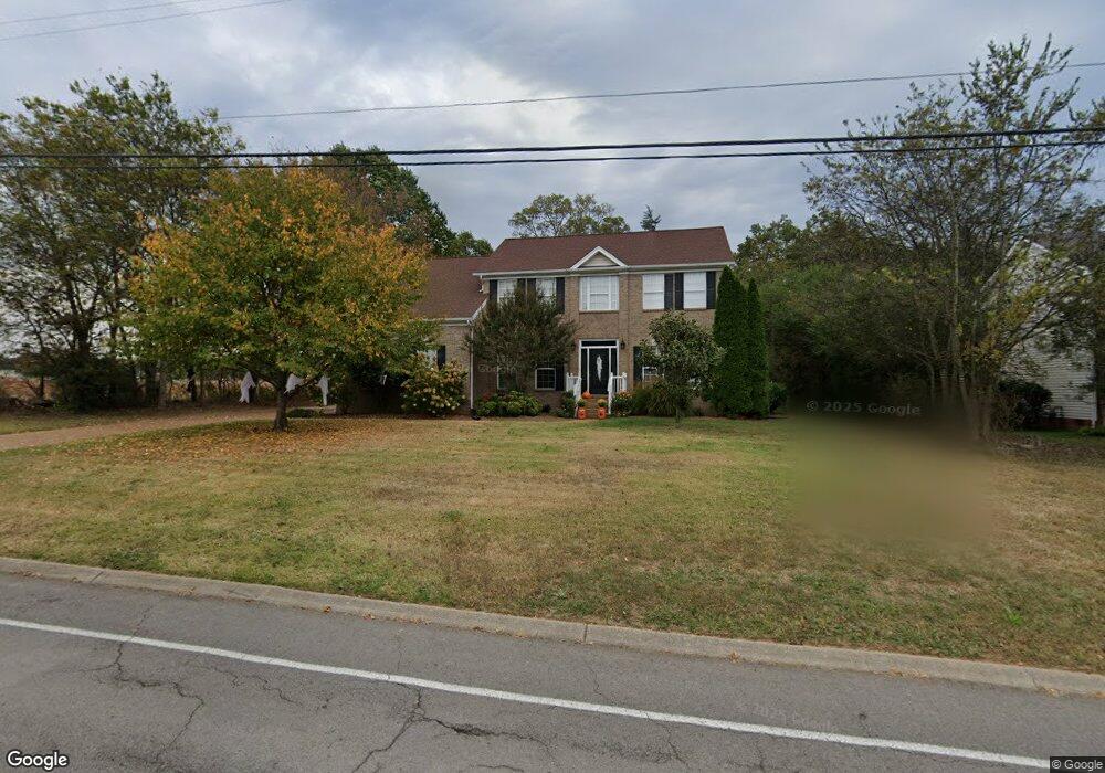
376 Baronswood Dr Nolensville, TN 37135
Estimated Value: $719,000 - $893,000
--
Bed
3
Baths
2,826
Sq Ft
$274/Sq Ft
Est. Value
About This Home
This home is located at 376 Baronswood Dr, Nolensville, TN 37135 and is currently estimated at $773,066, approximately $273 per square foot. 376 Baronswood Dr is a home located in Williamson County with nearby schools including Nolensville Elementary School, Mill Creek Middle School, and Nolensville High School.
Ownership History
Date
Name
Owned For
Owner Type
Purchase Details
Closed on
Dec 10, 2008
Sold by
Ayers Patricia W and Ayers Patricia Ann
Bought by
Ayers Patricia W
Current Estimated Value
Home Financials for this Owner
Home Financials are based on the most recent Mortgage that was taken out on this home.
Original Mortgage
$124,000
Outstanding Balance
$81,477
Interest Rate
6.1%
Mortgage Type
Purchase Money Mortgage
Estimated Equity
$691,589
Purchase Details
Closed on
Jun 18, 2004
Sold by
Ayers Micheal Patrick
Bought by
Ayers Patricia Ann
Purchase Details
Closed on
May 27, 1999
Sold by
Fox Ridge Homes Inc
Bought by
Ayers Michael P and Ayers Patricia W
Home Financials for this Owner
Home Financials are based on the most recent Mortgage that was taken out on this home.
Original Mortgage
$191,140
Interest Rate
6.84%
Create a Home Valuation Report for This Property
The Home Valuation Report is an in-depth analysis detailing your home's value as well as a comparison with similar homes in the area
Home Values in the Area
Average Home Value in this Area
Purchase History
| Date | Buyer | Sale Price | Title Company |
|---|---|---|---|
| Ayers Patricia W | $298,000 | First American Title Ins Co | |
| Ayers Patricia Ann | -- | -- | |
| Ayers Michael P | $212,378 | -- |
Source: Public Records
Mortgage History
| Date | Status | Borrower | Loan Amount |
|---|---|---|---|
| Open | Ayers Patricia W | $124,000 | |
| Closed | Ayers Michael P | $191,140 |
Source: Public Records
Tax History Compared to Growth
Tax History
| Year | Tax Paid | Tax Assessment Tax Assessment Total Assessment is a certain percentage of the fair market value that is determined by local assessors to be the total taxable value of land and additions on the property. | Land | Improvement |
|---|---|---|---|---|
| 2025 | $2,439 | $178,375 | $46,250 | $132,125 |
| 2024 | $2,439 | $112,375 | $18,750 | $93,625 |
| 2023 | $2,439 | $112,375 | $18,750 | $93,625 |
| 2022 | $2,439 | $112,375 | $18,750 | $93,625 |
| 2021 | $2,439 | $112,375 | $18,750 | $93,625 |
| 2020 | $2,143 | $85,375 | $15,000 | $70,375 |
| 2019 | $2,023 | $85,375 | $15,000 | $70,375 |
| 2018 | $1,964 | $85,375 | $15,000 | $70,375 |
| 2017 | $1,946 | $85,375 | $15,000 | $70,375 |
| 2016 | $1,921 | $85,375 | $15,000 | $70,375 |
| 2015 | -- | $71,600 | $12,500 | $59,100 |
| 2014 | -- | $71,600 | $12,500 | $59,100 |
Source: Public Records
Map
Nearby Homes
- 373 Baronswood Dr
- Ansley Plan at The Mill at McFarlin - Estates Series
- Kingston Plan at The Mill at McFarlin - Estates Series
- Weston Plan at The Mill at McFarlin - Estates Series
- Buchanan Plan at The Mill at McFarlin - Estates Series
- 625 Mer Rouge Dr
- 2207 Potter Place
- 2211 Potter Place
- 4137 Brendlyn Dr
- 2222 Potter Place
- 2215 Potter Place
- 4133 Brendlyn Dr
- 2219 Potter Place
- 2223 Potter Place
- 3009 Winterberry Dr
- 4141 Brendlyn Dr
- 4129 Brendlyn Dr
- 2202 Paden Rd
- 2248 Rolling Hills Dr
- 3006 Winterberry Dr
- 372 Baronswood Dr
- 368 Baronswood Dr
- 377 Baronswood Dr
- 364 Baronswood Dr
- 369 Baronswood Dr
- 365 Baronswood Dr
- 361 Baronswood Dr
- 2171 Kidd Rd
- 340 Baronswood Dr
- 341 Baronswood Dr
- 336 Baronswood Dr
- 337 Baronswood Dr
- 332 Baronswood Dr
- 333 Baronswood Dr
- 2167 Kidd Rd
- 328 Baronswood Dr
- 2183 Kidd Rd
- 329 Baronswood Dr
- 324 Baronswood Dr
- 325 Baronswood Dr