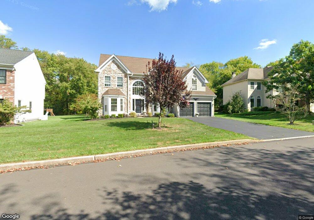
3763 E Brandon Way Doylestown, PA 18902
Estimated Value: $860,917 - $978,000
4
Beds
3
Baths
3,300
Sq Ft
$278/Sq Ft
Est. Value
About This Home
This home is located at 3763 E Brandon Way, Doylestown, PA 18902 and is currently estimated at $918,979, approximately $278 per square foot. 3763 E Brandon Way is a home located in Bucks County with nearby schools including Cold Spring Elementary School, Holicong Middle School, and Central Bucks High School - East.
Ownership History
Date
Name
Owned For
Owner Type
Purchase Details
Closed on
May 4, 1999
Sold by
Wemett Kevin B and Wemett Judith E
Bought by
Mcmorris Donald and Mcmorris Carol
Current Estimated Value
Home Financials for this Owner
Home Financials are based on the most recent Mortgage that was taken out on this home.
Original Mortgage
$233,600
Interest Rate
7.61%
Purchase Details
Closed on
Oct 7, 1996
Sold by
Barnside Development Company Lp
Bought by
Wemett Kevin B and Wemett Judith E
Home Financials for this Owner
Home Financials are based on the most recent Mortgage that was taken out on this home.
Original Mortgage
$233,950
Interest Rate
6.62%
Create a Home Valuation Report for This Property
The Home Valuation Report is an in-depth analysis detailing your home's value as well as a comparison with similar homes in the area
Home Values in the Area
Average Home Value in this Area
Purchase History
| Date | Buyer | Sale Price | Title Company |
|---|---|---|---|
| Mcmorris Donald | $292,000 | Fidelity National Title Ins | |
| Wemett Kevin B | $252,125 | -- |
Source: Public Records
Mortgage History
| Date | Status | Borrower | Loan Amount |
|---|---|---|---|
| Previous Owner | Mcmorris Donald | $233,600 | |
| Previous Owner | Wemett Kevin B | $233,950 | |
| Closed | Mcmorris Donald | $14,600 |
Source: Public Records
Tax History Compared to Growth
Tax History
| Year | Tax Paid | Tax Assessment Tax Assessment Total Assessment is a certain percentage of the fair market value that is determined by local assessors to be the total taxable value of land and additions on the property. | Land | Improvement |
|---|---|---|---|---|
| 2025 | $8,232 | $50,560 | $10,280 | $40,280 |
| 2024 | $8,232 | $50,560 | $10,280 | $40,280 |
| 2023 | $7,953 | $50,560 | $10,280 | $40,280 |
| 2022 | $7,858 | $50,560 | $10,280 | $40,280 |
| 2021 | $7,763 | $50,560 | $10,280 | $40,280 |
| 2020 | $7,763 | $50,560 | $10,280 | $40,280 |
| 2019 | $7,713 | $50,560 | $10,280 | $40,280 |
| 2018 | $7,713 | $50,560 | $10,280 | $40,280 |
| 2017 | $7,650 | $50,560 | $10,280 | $40,280 |
| 2016 | $7,726 | $50,560 | $10,280 | $40,280 |
| 2015 | -- | $50,560 | $10,280 | $40,280 |
| 2014 | -- | $50,560 | $10,280 | $40,280 |
Source: Public Records
Map
Nearby Homes
- 4848 Tall Oak Ct
- 5063 Sagewood Ct
- 3689 Hancock Ln
- 5184 Lovering Dr
- 3821 Nanlyn Farm Cir
- 3479 Durham Rd
- 3455 Durham Rd
- 4928 Edgewood Rd
- 4925 Redfield Rd
- 3468 Holicong Rd
- 4672 Woodfield Cir
- 3378 Holicong Rd
- 5491 Long Ln
- 4190 Milords Ln
- 4221 Sir Andrew Cir
- 6185 Mechanicsville Rd
- 4245 Mechanicsville Rd
- 46 John Dyer Way
- 4964 Point Pleasant Pike
- 5730 Carversville Rd
- 3769 E Brandon Way
- 3755 E Brandon Way
- 3773 E Brandon Way
- 3747 E Brandon Way
- 3783 E Brandon Way
- 4898 Crosspoint Dr
- 4910 Crosspoint Dr
- 4916 Crosspoint Dr
- 4902 Crosspoint Dr
- 4898 Tall Oak Ct
- 4924 Crosspoint Dr
- 3791 E Brandon Way
- 4893 Tall Oak Ct
- 4930 Crosspoint Dr
- 3786 E Brandon Way
- 3734 E Brandon Way
- 4955 Melissa Ct
- 4870 Green Heather Ct
- 3799 E Brandon Way
- 4885 Tall Oak Ct