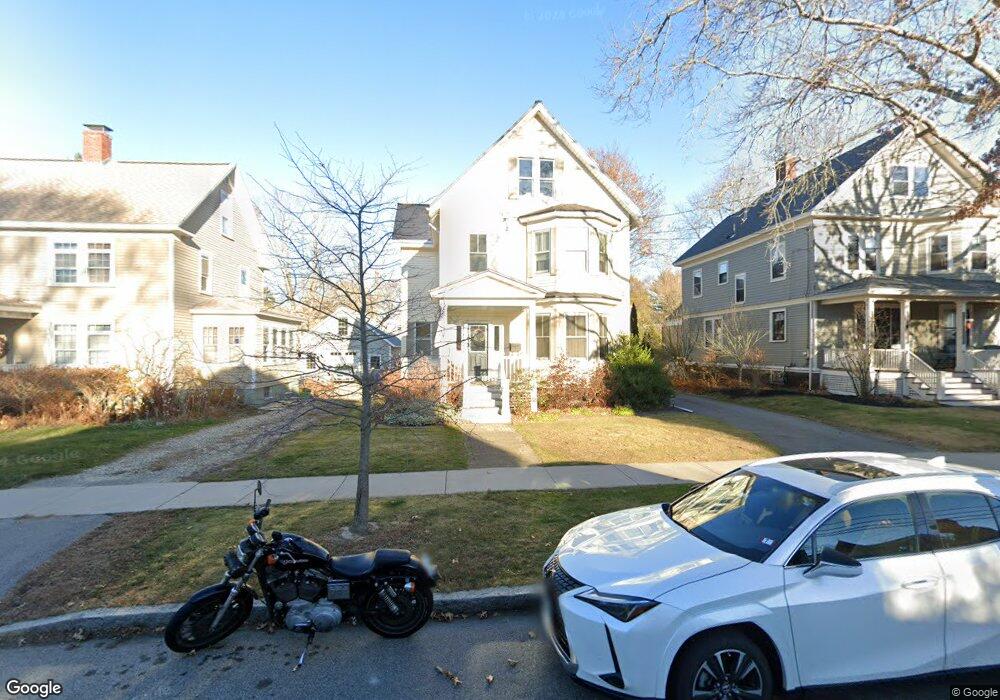
377 Richards Ave Portsmouth, NH 03801
Estimated Value: $1,867,617 - $2,043,000
3
Beds
3
Baths
2,589
Sq Ft
$745/Sq Ft
Est. Value
About This Home
This home is located at 377 Richards Ave, Portsmouth, NH 03801 and is currently estimated at $1,928,654, approximately $744 per square foot. 377 Richards Ave is a home located in Rockingham County with nearby schools including Little Harbour School, Portsmouth Middle School, and Portsmouth High School.
Ownership History
Date
Name
Owned For
Owner Type
Purchase Details
Closed on
May 4, 2022
Sold by
Scott Steven S and Scott Karin M
Bought by
Scott Ft
Current Estimated Value
Purchase Details
Closed on
Aug 11, 1995
Bought by
Scott Steven S and Scott Karin M
Create a Home Valuation Report for This Property
The Home Valuation Report is an in-depth analysis detailing your home's value as well as a comparison with similar homes in the area
Home Values in the Area
Average Home Value in this Area
Purchase History
| Date | Buyer | Sale Price | Title Company |
|---|---|---|---|
| Scott Ft | -- | None Available | |
| Scott Steven S | -- | -- |
Source: Public Records
Mortgage History
| Date | Status | Borrower | Loan Amount |
|---|---|---|---|
| Previous Owner | Scott Steven S | $401,500 | |
| Previous Owner | Scott Steven S | $397,000 |
Source: Public Records
Tax History Compared to Growth
Tax History
| Year | Tax Paid | Tax Assessment Tax Assessment Total Assessment is a certain percentage of the fair market value that is determined by local assessors to be the total taxable value of land and additions on the property. | Land | Improvement |
|---|---|---|---|---|
| 2024 | $18,074 | $1,616,600 | $843,700 | $772,900 |
| 2023 | $13,715 | $850,300 | $429,300 | $421,000 |
| 2022 | $12,849 | $845,300 | $429,300 | $416,000 |
| 2021 | $12,705 | $845,300 | $429,300 | $416,000 |
| 2020 | $12,426 | $845,300 | $429,300 | $416,000 |
| 2019 | $12,561 | $845,300 | $429,300 | $416,000 |
| 2018 | $6,821 | $760,700 | $390,200 | $370,500 |
| 2017 | $11,461 | $757,300 | $390,200 | $367,100 |
| 2016 | $11,274 | $661,600 | $336,800 | $324,800 |
| 2015 | $11,108 | $661,600 | $336,800 | $324,800 |
| 2014 | $9,694 | $535,600 | $242,800 | $292,800 |
| 2013 | $9,616 | $536,900 | $242,800 | $294,100 |
| 2012 | $9,423 | $536,900 | $242,800 | $294,100 |
Source: Public Records
Map
Nearby Homes
- 34 Highland St
- 210 South St
- 161 Wibird St
- 21 Madison St
- 238 Austin St
- 5 Old Parish Way
- 115 Court St
- 219 Sagamore Ave
- 405 Pleasant St
- 198 Islington St Unit 6
- 4 Rock St Unit B
- 325 Marcy St
- 90 Fleet St Unit 4-5
- 51 Islington St Unit 406
- 332 Hanover St
- 18 Congress St Unit 308
- 33 Gardner St
- 70 Maplewood Ave Unit 305
- 70 Maplewood Ave Unit 202
- 70 Maplewood Ave Unit 204
- 367 Richards Ave
- 357 Richards Ave
- 399 Richards Ave
- 140 Sherburne Ave
- 128 Sherburne Ave
- 150 Sherburne Ave
- 409 Richards Ave
- 160 Sherburne Ave
- 337 Richards Ave
- 380 Richards Ave
- 370 Richards Ave
- 180 Lincoln Ave
- 419 Richards Ave
- 390 Richards Ave
- 170 Sherburne Ave
- 356 Richards Ave
- 168 Lincoln Ave
- 346 Richards Ave
- 410 Richards Ave
- 429 Richards Ave