Estimated Value: $319,000 - $443,000
2
Beds
1
Bath
947
Sq Ft
$420/Sq Ft
Est. Value
About This Home
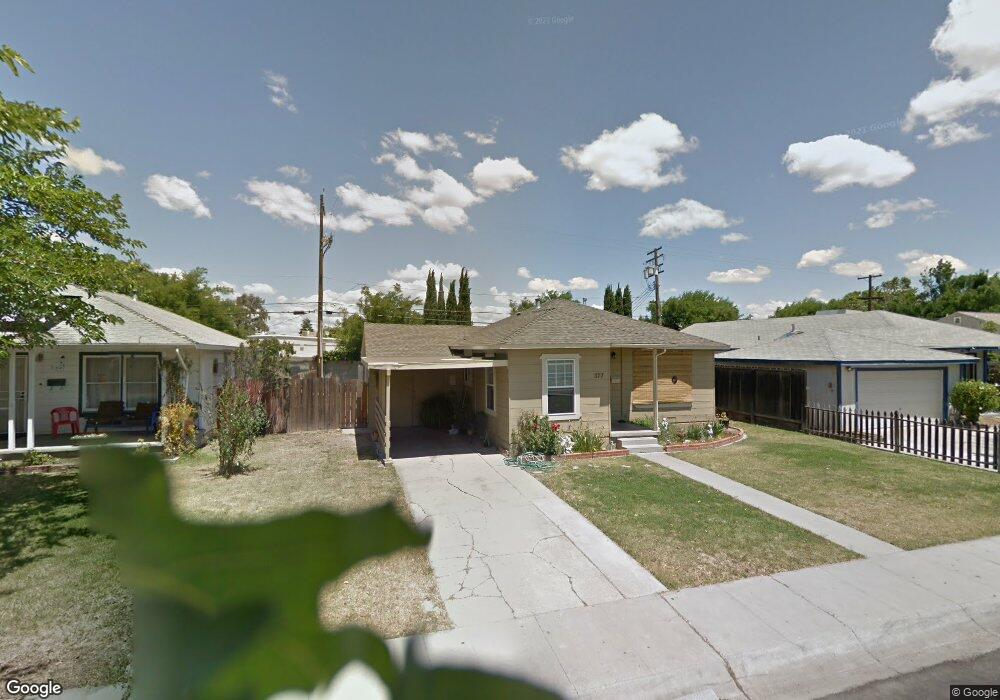
This home is located at 377 W 23rd St, Tracy, CA 95376 and is currently estimated at $397,386, approximately $419 per square foot. 377 W 23rd St is a home located in San Joaquin County with nearby schools including Central Elementary School, Merrill F. West High School, and Primary Charter School.
Ownership History
Date
Name
Owned For
Owner Type
Purchase Details
Closed on
Mar 16, 2009
Sold by
Tuso Charles J and Tuso Marilyn L
Bought by
Tuso Charles J and Tuso Marilyn L
Current Estimated Value
Purchase Details
Closed on
Dec 10, 1993
Sold by
Tuso Charles J and Tuso Marilyn L
Bought by
Tuso Charles J and Tuso Marilyn L
Home Financials for this Owner
Home Financials are based on the most recent Mortgage that was taken out on this home.
Original Mortgage
$77,000
Interest Rate
6.89%
Create a Home Valuation Report for This Property
The Home Valuation Report is an in-depth analysis detailing your home's value as well as a comparison with similar homes in the area
Home Values in the Area
Average Home Value in this Area
Purchase History
| Date | Buyer | Sale Price | Title Company |
|---|---|---|---|
| Tuso Charles J | -- | None Available | |
| Tuso Charles J | -- | Fidelity National Title Co |
Source: Public Records
Mortgage History
| Date | Status | Borrower | Loan Amount |
|---|---|---|---|
| Closed | Tuso Charles J | $77,000 |
Source: Public Records
Tax History Compared to Growth
Tax History
| Year | Tax Paid | Tax Assessment Tax Assessment Total Assessment is a certain percentage of the fair market value that is determined by local assessors to be the total taxable value of land and additions on the property. | Land | Improvement |
|---|---|---|---|---|
| 2025 | $1,814 | $156,327 | $119,546 | $36,781 |
| 2024 | $1,672 | $153,262 | $117,202 | $36,060 |
| 2023 | $1,646 | $150,257 | $114,904 | $35,353 |
| 2022 | $1,613 | $147,311 | $112,651 | $34,660 |
| 2021 | $1,594 | $144,424 | $110,443 | $33,981 |
| 2020 | $1,584 | $142,944 | $109,311 | $33,633 |
| 2019 | $1,559 | $140,142 | $107,168 | $32,974 |
| 2018 | $1,533 | $137,395 | $105,067 | $32,328 |
| 2017 | $1,457 | $134,702 | $103,007 | $31,695 |
| 2016 | $1,475 | $132,061 | $100,988 | $31,073 |
| 2014 | $1,378 | $127,530 | $97,523 | $30,007 |
Source: Public Records
Map
Nearby Homes
- 546 W Grant Line Rd
- 111 W 23rd St
- 110 W 23rd St
- 2192 Wildflower Ct
- 2840-2896 Holly Dr
- 2254 Morningside Ct Unit 42
- 2214 Morningside Ct
- 80 Portola Way Unit 104
- 80 Portola Way Unit 105
- 16 Pereira Ave
- 262 W Lowell Ave
- 242 W Lowell Ave
- 228 W Lowell Ave
- 3054 Coventry Dr
- 41 W Kavanagh Ave
- 930 Plantation Ct
- 2613 Balboa Dr
- 971 Plantation Ct
- 1561 Bessie Ave
- 1792 Chester Dr