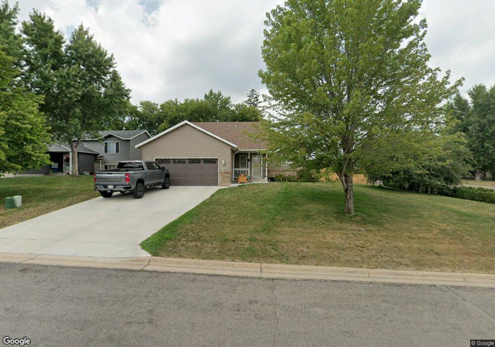
379 Killinger Cir Sauk Rapids, MN 56379
Estimated Value: $287,000 - $301,000
3
Beds
1
Bath
1,120
Sq Ft
$261/Sq Ft
Est. Value
About This Home
This home is located at 379 Killinger Cir, Sauk Rapids, MN 56379 and is currently estimated at $292,807, approximately $261 per square foot. 379 Killinger Cir is a home located in Benton County with nearby schools including Pleasant View Elementary School, Sauk Rapids-Rice Middle School, and Sauk Rapids-Rice Senior High School.
Ownership History
Date
Name
Owned For
Owner Type
Purchase Details
Closed on
Jan 14, 2005
Sold by
Grabinski Michael J and Grabinski Jessica L
Bought by
Knapek Denise M
Current Estimated Value
Home Financials for this Owner
Home Financials are based on the most recent Mortgage that was taken out on this home.
Original Mortgage
$139,920
Outstanding Balance
$71,343
Interest Rate
5.9%
Mortgage Type
New Conventional
Estimated Equity
$221,464
Create a Home Valuation Report for This Property
The Home Valuation Report is an in-depth analysis detailing your home's value as well as a comparison with similar homes in the area
Home Values in the Area
Average Home Value in this Area
Purchase History
| Date | Buyer | Sale Price | Title Company |
|---|---|---|---|
| Knapek Denise M | $174,900 | None Available |
Source: Public Records
Mortgage History
| Date | Status | Borrower | Loan Amount |
|---|---|---|---|
| Open | Knapek Denise M | $139,920 |
Source: Public Records
Tax History
| Year | Tax Paid | Tax Assessment Tax Assessment Total Assessment is a certain percentage of the fair market value that is determined by local assessors to be the total taxable value of land and additions on the property. | Land | Improvement |
|---|---|---|---|---|
| 2025 | $3,778 | $285,500 | $35,000 | $250,500 |
| 2024 | $3,186 | $270,900 | $35,000 | $235,900 |
| 2023 | $3,030 | $272,200 | $35,000 | $237,200 |
| 2022 | $2,798 | $239,400 | $31,800 | $207,600 |
| 2021 | $2,550 | $204,800 | $31,800 | $173,000 |
| 2018 | $2,172 | $145,400 | $26,547 | $118,853 |
| 2017 | $2,172 | $131,700 | $26,000 | $105,700 |
| 2016 | $2,114 | $151,200 | $30,600 | $120,600 |
| 2015 | $2,124 | $116,600 | $25,287 | $91,313 |
| 2014 | -- | $111,000 | $24,975 | $86,025 |
| 2013 | -- | $112,400 | $25,051 | $87,349 |
Source: Public Records
Map
Nearby Homes
- 1401 4 1/2 Ave N
- 18th 18th
- 1809 Eastern Star Loop
- 233 Pleasant Ridge Dr
- 870 18th St NW
- 820 18th St NW
- 390 18th Street Ct NW
- 1804 Oak Pond Dr
- 1209 Oak Pond Dr
- 1806 Oak Pond Dr
- 709 N Benton Dr
- 1107 10th Ave N
- 720 3rd Ave N
- 113 14th Ave N
- 111 14th Ave N
- 1914 N Benton Dr
- 122 Benton Oaks Dr
- 121 14th Ave N
- 115 14th Ave N
- 117 14th Ave N
- 369 Killinger Cir
- 356 Welsh Ct
- 378 Killinger Cir
- 363 Killinger Cir
- 370 Killinger Cir
- 1402 4th Ave N
- 0 Xxx 4th Ave N
- 1406 4th Ave N
- 360 Welsh Ct
- 360 Killinger Cir
- 352 Welsh Ct
- 1310 4th Ave N
- 364 Killinger Cir
- 364 Welsh Ct
- 400 15th St N
- 1306 4th Ave N
- 1350 13th Street Cir
- 377 13th St N
- 348 Welsh Ct
- 371 13th St N
Your Personal Tour Guide
Ask me questions while you tour the home.