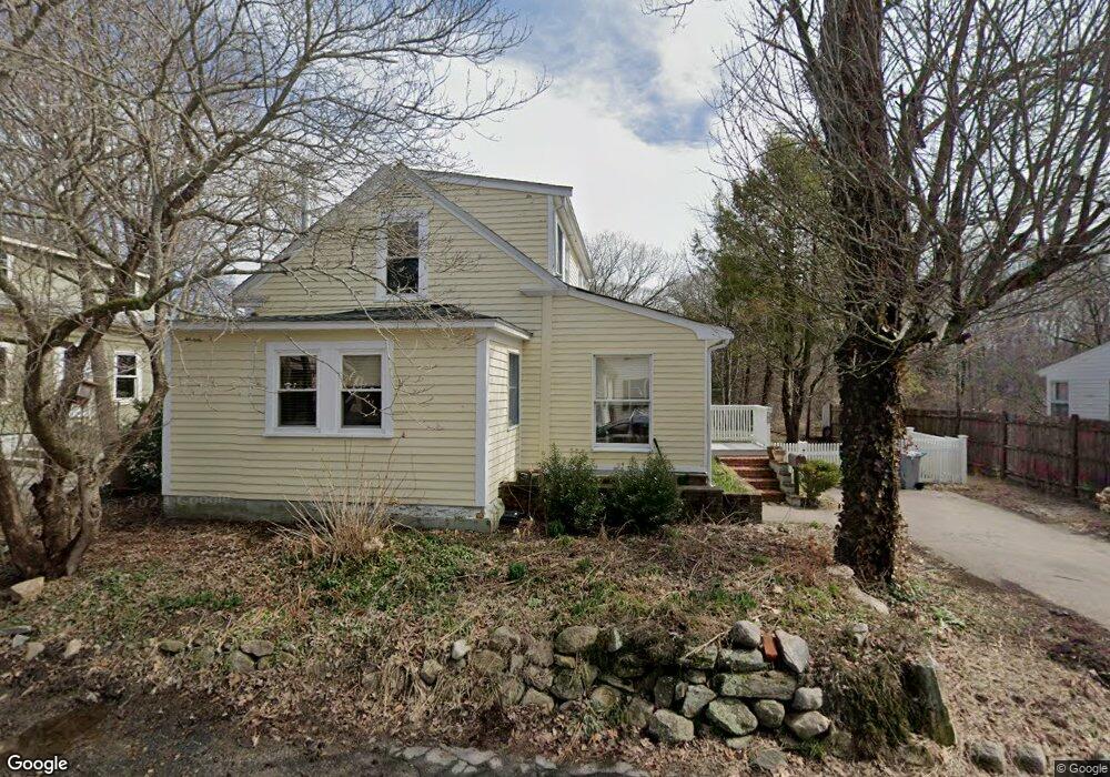
38 Arch St Holliston, MA 01746
Estimated Value: $519,000 - $640,000
2
Beds
1
Bath
1,335
Sq Ft
$438/Sq Ft
Est. Value
About This Home
This home is located at 38 Arch St, Holliston, MA 01746 and is currently estimated at $584,317, approximately $437 per square foot. 38 Arch St is a home located in Middlesex County with nearby schools including Miller Elementary School, Robert H. Adams Middle School, and Holliston High School.
Ownership History
Date
Name
Owned For
Owner Type
Purchase Details
Closed on
Jul 14, 2014
Sold by
Salkind Carol
Bought by
38 Arch Street Rt and Salkind Carol H
Current Estimated Value
Purchase Details
Closed on
Jul 12, 2005
Sold by
Murdock Karla K and Murdock Robert C
Bought by
Salkind Carol
Purchase Details
Closed on
Jul 15, 1999
Sold by
Chapuis Carol
Bought by
Murdock Robert C and Murdock Karla K
Home Financials for this Owner
Home Financials are based on the most recent Mortgage that was taken out on this home.
Original Mortgage
$160,200
Interest Rate
7.39%
Mortgage Type
Purchase Money Mortgage
Purchase Details
Closed on
Apr 16, 1992
Sold by
Horowitz Steven E and Dijxhoorn Elsbeth
Bought by
Chapuis Carol
Home Financials for this Owner
Home Financials are based on the most recent Mortgage that was taken out on this home.
Original Mortgage
$126,000
Interest Rate
8.75%
Mortgage Type
Purchase Money Mortgage
Create a Home Valuation Report for This Property
The Home Valuation Report is an in-depth analysis detailing your home's value as well as a comparison with similar homes in the area
Home Values in the Area
Average Home Value in this Area
Purchase History
| Date | Buyer | Sale Price | Title Company |
|---|---|---|---|
| 38 Arch Street Rt | -- | -- | |
| Salkind Carol | $341,500 | -- | |
| Murdock Robert C | $178,000 | -- | |
| Chapuis Carol | $140,000 | -- |
Source: Public Records
Mortgage History
| Date | Status | Borrower | Loan Amount |
|---|---|---|---|
| Previous Owner | Chapuis Carol | $160,200 | |
| Previous Owner | Chapuis Carol | $121,000 | |
| Previous Owner | Chapuis Carol | $126,000 |
Source: Public Records
Tax History Compared to Growth
Tax History
| Year | Tax Paid | Tax Assessment Tax Assessment Total Assessment is a certain percentage of the fair market value that is determined by local assessors to be the total taxable value of land and additions on the property. | Land | Improvement |
|---|---|---|---|---|
| 2025 | $8,249 | $563,100 | $249,100 | $314,000 |
| 2024 | $7,804 | $518,200 | $249,100 | $269,100 |
| 2023 | $7,355 | $477,600 | $249,100 | $228,500 |
| 2022 | $8,028 | $461,900 | $249,100 | $212,800 |
| 2021 | $7,103 | $397,900 | $185,100 | $212,800 |
| 2020 | $6,895 | $365,800 | $199,300 | $166,500 |
| 2019 | $6,579 | $349,400 | $189,800 | $159,600 |
| 2018 | $6,523 | $349,400 | $189,800 | $159,600 |
| 2017 | $6,786 | $366,400 | $195,500 | $170,900 |
| 2016 | $6,706 | $356,900 | $186,000 | $170,900 |
| 2015 | $6,076 | $313,500 | $161,500 | $152,000 |
Source: Public Records
Map
Nearby Homes
- 154 Union St
- 1366 Washington St
- 1037 Washington St
- 156 Mitchell Rd
- 1014 Highland St
- 43 Bittersweet Cir Unit 43
- 625 Norfolk St
- 7 Hill St
- 160 Winter St
- 0 Hill St
- 11 Francine Dr
- 266 Willowgate Rise
- 140 Goulding St
- 27 Richardson Dr Unit 27
- 116 Winthrop St
- 1 Jameson Dr Unit 1
- 3 Jameson Dr Unit 3
- 54 Westfield Dr
- 75 Ridge Rd
- 56 Roy Ave