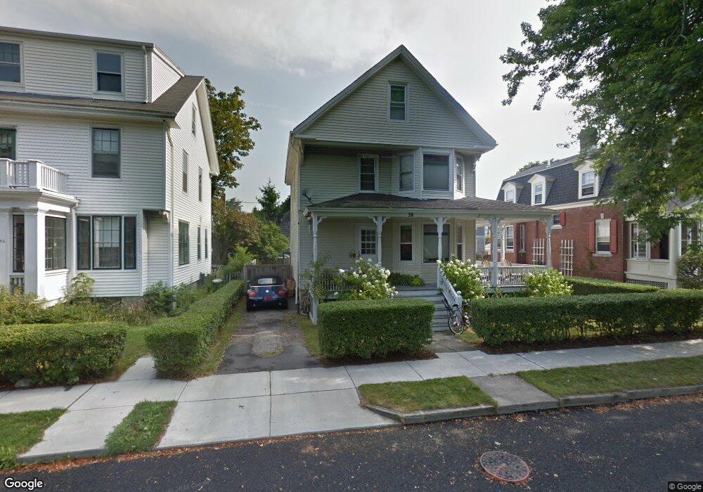
38 Berkeley Ave Newport, RI 02840
Memorial Boulevard NeighborhoodEstimated Value: $991,057 - $1,309,000
4
Beds
2
Baths
1,655
Sq Ft
$678/Sq Ft
Est. Value
About This Home
This home is located at 38 Berkeley Ave, Newport, RI 02840 and is currently estimated at $1,122,764, approximately $678 per square foot. 38 Berkeley Ave is a home located in Newport County with nearby schools including Rogers High School, St Michael's Country Day School, and St George's School.
Ownership History
Date
Name
Owned For
Owner Type
Purchase Details
Closed on
Dec 20, 2016
Sold by
Dehoesey 3Rd Reed D and Dehorsey Allison I
Bought by
Dehoesey 3Rd Reed D
Current Estimated Value
Purchase Details
Closed on
Oct 30, 1991
Sold by
Salvation Army
Bought by
Dehorsey Reed
Create a Home Valuation Report for This Property
The Home Valuation Report is an in-depth analysis detailing your home's value as well as a comparison with similar homes in the area
Home Values in the Area
Average Home Value in this Area
Purchase History
| Date | Buyer | Sale Price | Title Company |
|---|---|---|---|
| Dehoesey 3Rd Reed D | -- | -- | |
| Dehorsey Reed | $127,500 | -- |
Source: Public Records
Mortgage History
| Date | Status | Borrower | Loan Amount |
|---|---|---|---|
| Previous Owner | Dehorsey Reed | $350,000 | |
| Previous Owner | Dehorsey Reed | $75,000 | |
| Previous Owner | Dehorsey Reed | $117,107 | |
| Previous Owner | Dehorsey Reed | $120,000 |
Source: Public Records
Tax History
| Year | Tax Paid | Tax Assessment Tax Assessment Total Assessment is a certain percentage of the fair market value that is determined by local assessors to be the total taxable value of land and additions on the property. | Land | Improvement |
|---|---|---|---|---|
| 2025 | $6,117 | $852,000 | $381,000 | $471,000 |
| 2024 | $7,003 | $852,000 | $381,000 | $471,000 |
| 2023 | $5,555 | $560,000 | $249,000 | $311,000 |
| 2022 | $5,382 | $560,000 | $249,000 | $311,000 |
| 2021 | $5,225 | $560,000 | $249,000 | $311,000 |
| 2020 | $4,657 | $453,000 | $220,400 | $232,600 |
| 2019 | $4,657 | $453,000 | $220,400 | $232,600 |
| 2018 | $4,525 | $453,000 | $220,400 | $232,600 |
| 2017 | $3,805 | $339,400 | $157,600 | $181,800 |
| 2016 | $3,710 | $339,400 | $157,600 | $181,800 |
| 2015 | $3,621 | $339,400 | $157,600 | $181,800 |
| 2014 | $3,788 | $314,100 | $133,900 | $180,200 |
Source: Public Records
Map
Nearby Homes
- 19 Slocum St
- 21 Slocum St
- 20 Berkeley Ave Unit 2
- 26 Freebody St
- 5 Lowndes St
- 5 Dresser St
- 10 Ocean Lawn Ln
- 20 East St Unit 2A
- 421 Bellevue Ave Unit 3B
- 2 Perry St
- 7 Red Cross Ave
- 27 Dean Ave
- 1 Oakwood Terrace Unit 7
- 66 Webster St Unit 9
- 24 Old Beach Rd
- 14 Lee Ave
- 4 Red Cross Ave Unit 4
- 6 Sharon Ct
- 75 Pelham St Unit B
- 20 Fair St
- 40 Berkeley Ave
- 36 Berkeley Ave
- 17 Slocum St
- 21 Slocum St Unit 1
- 34 Berkeley Ave
- 15 Slocum St
- 15 Slocum St Unit 1
- 35 Berkeley Ave Unit 37
- 63 Middleton Ave
- 32 Berkeley Ave
- 59 Middleton Ave
- 52 Berkeley Ave
- 5 Slocum St
- 5 Slocum St Unit 1
- 5 Slocum St Unit 2
- 57 Middleton Ave
- 33 Berkeley Ave
- 41 Berkeley Ave
- 45 E Bowery St
- 45 E Bowery St Unit A
Your Personal Tour Guide
Ask me questions while you tour the home.