Estimated Value: $700,512 - $851,000
3
Beds
3
Baths
3,800
Sq Ft
$204/Sq Ft
Est. Value
About This Home
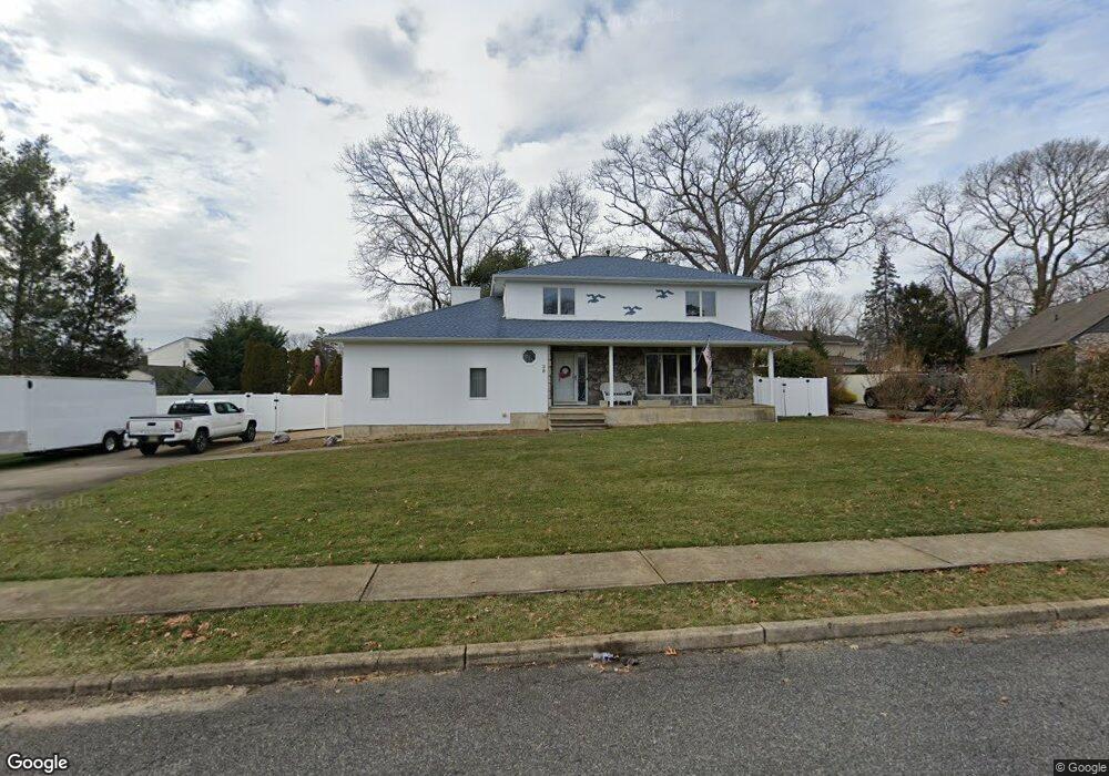
This home is located at 38 Harmony Ln, Brick, NJ 08724 and is currently estimated at $774,378, approximately $203 per square foot. 38 Harmony Ln is a home located in Ocean County with nearby schools including Midstreams Elementary School, Veterans Memorial Middle School, and Brick Township Memorial High School.
Ownership History
Date
Name
Owned For
Owner Type
Purchase Details
Closed on
Mar 2, 2023
Sold by
Kot Stanley V and Kot Karen A
Bought by
Stanley Kot And Karen Kot Irrevocable Grantor and Kot
Current Estimated Value
Purchase Details
Closed on
Jul 16, 2002
Sold by
Rich Michael
Bought by
Kot Stanley and Kot Karen
Home Financials for this Owner
Home Financials are based on the most recent Mortgage that was taken out on this home.
Original Mortgage
$85,000
Interest Rate
6.39%
Purchase Details
Closed on
Dec 15, 1997
Sold by
Vollmann Frank J and Vollmann Jeanne E
Bought by
Rich Michael and Rich Bonnie
Home Financials for this Owner
Home Financials are based on the most recent Mortgage that was taken out on this home.
Original Mortgage
$195,000
Interest Rate
7.14%
Create a Home Valuation Report for This Property
The Home Valuation Report is an in-depth analysis detailing your home's value as well as a comparison with similar homes in the area
Home Values in the Area
Average Home Value in this Area
Purchase History
| Date | Buyer | Sale Price | Title Company |
|---|---|---|---|
| Stanley Kot And Karen Kot Irrevocable Grantor | -- | None Listed On Document | |
| Stanley Kot And Karen Kot Irrevocable Grantor | -- | None Listed On Document | |
| Kot Stanley | $365,000 | -- | |
| Rich Michael | $225,000 | -- |
Source: Public Records
Mortgage History
| Date | Status | Borrower | Loan Amount |
|---|---|---|---|
| Previous Owner | Kot Stanley | $85,000 | |
| Previous Owner | Rich Michael | $195,000 |
Source: Public Records
Tax History
| Year | Tax Paid | Tax Assessment Tax Assessment Total Assessment is a certain percentage of the fair market value that is determined by local assessors to be the total taxable value of land and additions on the property. | Land | Improvement |
|---|---|---|---|---|
| 2025 | $9,594 | $367,600 | $146,600 | $221,000 |
| 2024 | $8,855 | $367,600 | $146,600 | $221,000 |
Source: Public Records
Map
Nearby Homes
- 13 Golden Rod Ct
- 4 East Trail
- 74 Fairview Ave
- 17 East Trail
- 3 C Trail
- 1 Princeton Pines Place
- 36 Sleepy Hollow Dr
- 94 Sleepy Hollow Dr
- 24 Davos Rd
- 982 Falkenberg Rd
- 241 Old Squan Rd
- 209 Winchester Dr
- 140 Meridian Dr
- 313 Shawnee Dr
- 106 Arrowhead Park Dr
- 315 Shawnee Dr
- 14 Coolidge Dr
- 203 Lorraine Place
- 49 N Cherokee Ln
- 23 Island Dr
- 35 Sunnycrest Dr
- 37 Sunnycrest Dr
- 42 Harmony Ln
- 134 Laurelwood Rd
- 37 Harmony Ln
- 41 Sunnycrest Dr
- 35 Harmony Ln
- 144 Bonnie Ln
- 30 Harmony Ln
- 45 Sunnycrest Dr
- 129 Forest Rd
- 135 Laurelwood Rd
- 147 Bonnie Ln
- 130 Laurelwood Rd
- 31 Harmony Ln
- 148 Bonnie Ln
- 29 Edgewood Dr
- 47 Sunnycrest Dr
- 128 Forest Rd
- 32 Fieldcrest Ln
Your Personal Tour Guide
Ask me questions while you tour the home.