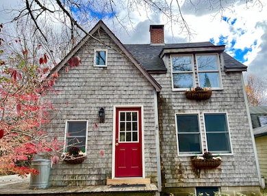
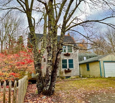
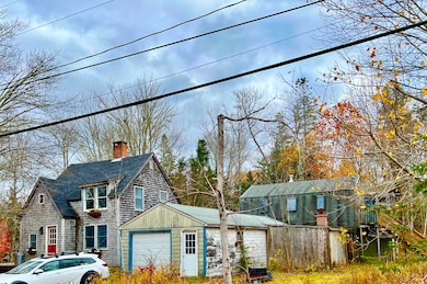
38 Indian Point Rd Bar Harbor, ME 04609
Estimated payment $2,743/month
Highlights
- Hot Property
- View of Trees or Woods
- Deck
- Conners-Emerson School Rated A
- 1.03 Acre Lot
- Wooded Lot
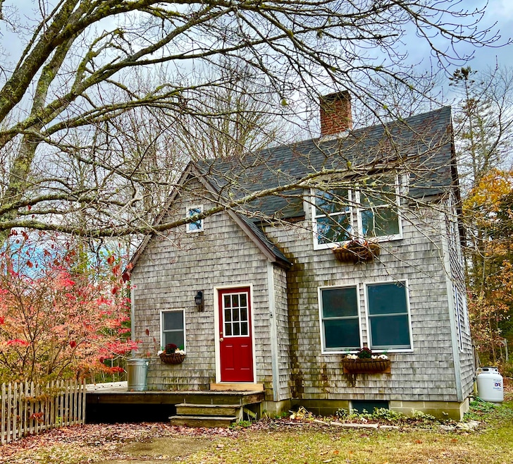
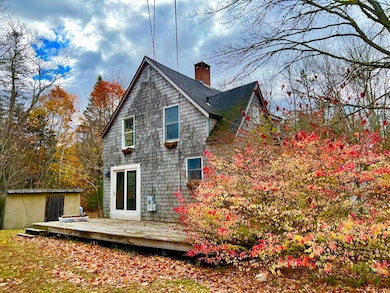
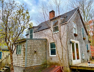
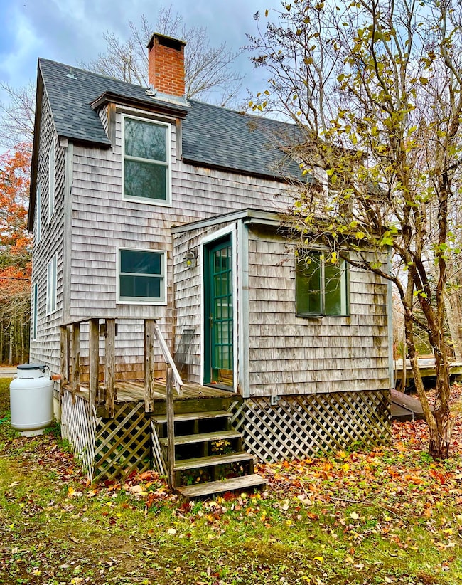
About This Home
This 1930's farmhouse has a living room with a cozy pellet stove, updated kitchen, dining room, and laundry area all on the first floor. On the second floor you will find a full bath and three bedrooms, one is small and could be a nursery, den or office. There is a detached one car garage with two large rooms attached to the back. Great for a shop, self employed person, etc. From outside you can take the stairs that go over the back room behind the garage and you will find a studio apartment. Open concept of kitchen, living room, dining area. A bedroom and a separate bath as well. Garage, two buildings behind and apartment are in need of TLC. Fix up for guests or have a year round rental to help pay the mortgage. Close proximity to the center of Town Hill which you will love. Great community! Great location!
Home Details
Home Type
- Single Family
Est. Annual Taxes
- $3,878
Year Built
- Built in 1930
Lot Details
- 1.03 Acre Lot
- Rural Setting
- Wooded Lot
- Property is zoned CC
Parking
- 1 Car Detached Garage
- Gravel Driveway
Home Design
- Farmhouse Style Home
- Flat Roof Shape
- Block Foundation
- Wood Frame Construction
- Pitched Roof
- Shingle Roof
- Wood Siding
Interior Spaces
- 950 Sq Ft Home
- Views of Woods
Kitchen
- Gas Range
- Dishwasher
Flooring
- Wood
- Carpet
- Laminate
- Vinyl
Bedrooms and Bathrooms
- 3 Bedrooms
- 1 Full Bathroom
- Bathtub
- Shower Only
Laundry
- Dryer
- Washer
Unfinished Basement
- Partial Basement
- Interior Basement Entry
- Sump Pump
- Dirt Floor
Outdoor Features
- Deck
- Shed
Utilities
- No Cooling
- Baseboard Heating
- Hot Water Heating System
- Private Water Source
- Well
- Septic Design Available
- Internet Available
Community Details
- No Home Owners Association
Listing and Financial Details
- Tax Lot 007
- Assessor Parcel Number BARH-000227-000000-000007
Map
Home Values in the Area
Average Home Value in this Area
Tax History
| Year | Tax Paid | Tax Assessment Tax Assessment Total Assessment is a certain percentage of the fair market value that is determined by local assessors to be the total taxable value of land and additions on the property. | Land | Improvement |
|---|---|---|---|---|
| 2024 | $3,878 | $386,300 | $194,100 | $192,200 |
| 2023 | $3,353 | $386,300 | $194,100 | $192,200 |
| 2022 | $3,046 | $326,800 | $164,200 | $162,600 |
| 2021 | $2,894 | $297,100 | $149,300 | $147,800 |
| 2020 | $2,428 | $204,000 | $126,800 | $77,200 |
| 2019 | $1,620 | $202,000 | $125,500 | $76,500 |
| 2018 | $2,335 | $202,000 | $125,500 | $76,500 |
| 2017 | $1,665 | $206,800 | $125,500 | $81,300 |
| 2016 | $2,219 | $206,800 | $125,500 | $81,300 |
| 2015 | $2,190 | $206,800 | $125,500 | $81,300 |
| 2014 | $2,113 | $206,800 | $125,500 | $81,300 |
| 2012 | $2,035 | $206,800 | $125,500 | $81,300 |
Property History
| Date | Event | Price | List to Sale | Price per Sq Ft |
|---|---|---|---|---|
| 11/14/2025 11/14/25 | For Sale | $459,000 | -- | $483 / Sq Ft |
Purchase History
| Date | Type | Sale Price | Title Company |
|---|---|---|---|
| Not Resolvable | $1,001 | -- |
Mortgage History
| Date | Status | Loan Amount | Loan Type |
|---|---|---|---|
| Open | $178,000 | Unknown | |
| Closed | $182,700 | Unknown |
Source: Maine Listings
MLS Number: 1643495
APN: BARH-000227-000000-000007
Disclaimer: Certain information contained herein is derived from information provided by parties other than Homes.com. All information provided is deemed reliable, but is not guaranteed to be accurate and should be independently verified.
![]() Listing data is derived in whole or in part from Maine Real Estate Information System, Inc. (d/b/a Maine Listings) and is for consumers' personal, noncommercial use only. Dimensions are approximate and not guaranteed. All data should be independently verified.
Listing data is derived in whole or in part from Maine Real Estate Information System, Inc. (d/b/a Maine Listings) and is for consumers' personal, noncommercial use only. Dimensions are approximate and not guaranteed. All data should be independently verified.
© 2025 Maine Real Estate Information System, Inc. All Rights Reserved. Equal Housing Opportunity.
Homes.com, LLC, 17600 Laguna Canyon Rd Irvine, CA 92618 (888)-952-6393
![]()
- 27 M J Ln
- 40 Fern Meadow Dr
- Lot 79-01 Knox Rd
- Lot 38 Arrowhead Rd
- 39 Kitteridge Brook Rd
- 16 Blodgett Ln
- 16 Blodgett Dr
- 34 Frenchmans Hill E
- 1427 State Highway 3
- Lot #9-4 Oak Hill Rd
- Lot 3 Belle Grande Dr
- Lot 4 Belle Grande Dr
- 0 Country Way
- Lot 5 Bluff Rd
- 1105 Main St
- 28 Winding Brook Rd
- Lot 001 Crooked Rd
- 37 Hanna Dr
- 40 Ridgeway Dr
- 480 Sound Dr
- 10 Colby Way
- 10 Colby Way
- 7 Colby Way Unit B
- 1374 Bucksport Rd Unit 1
- 88 Wildwood Dr
- 1318 Bald Mountain Rd
- 74 Battle Ave Unit B
- 5 West Dr
- 103 US Route 1 Unit 3upstairsunit
- 18 Wenbelle Dr Unit 328
- 18 Wenbelle Dr Unit 302
- 5 Bracken Ln
- 120 Rocky Shore Dr Unit A Lakeside apartment
- 3 Cushing St Unit 2
- 198 Main Rd N Unit B
- 109 Main Rd N Unit B
- 14 Atlantic Ave
- 64 Main St
- 64 Main St
- 46 Frances Dr
