
Seller's Agent in 2025
Aaron Johnson
RE/MAX
(774) 259-6959
4 in this area
129 Total Sales
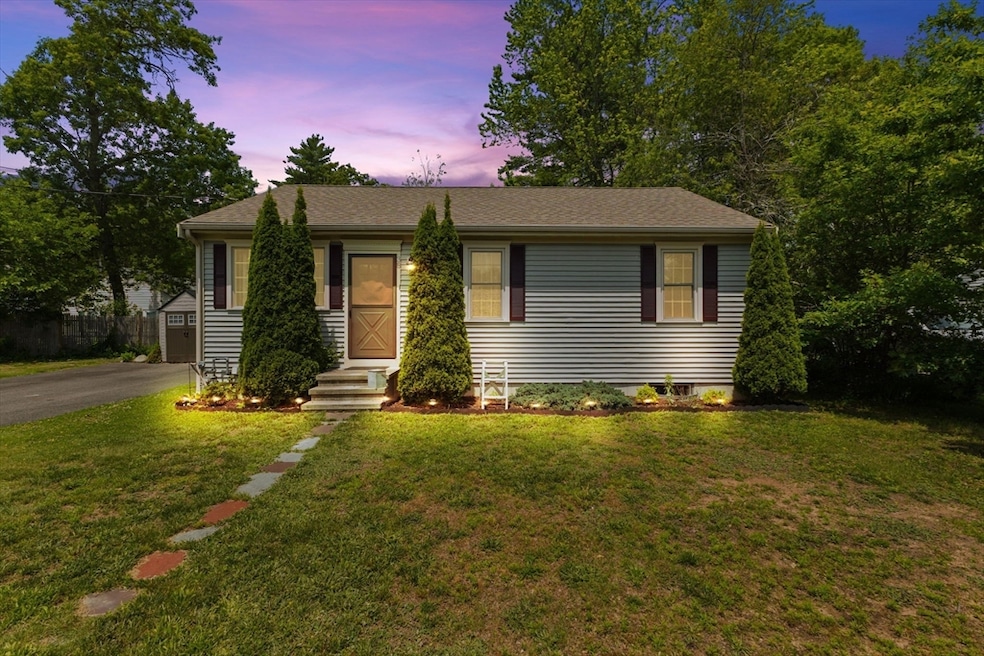


Welcome to 38 Kenmore. A beautifully transformed home that was fully renovated in 2014. This residence offers three spacious bedrooms and two full baths. Sunlight floods the heart of the home through striking sky lit cathedral ceilings in the kitchen, where modern finishes meet thoughtful design. Step outside to enjoy a fenced backyard alongside an inviting deck and patio ideal for summer cookouts, or quiet morning coffee. Downstairs, the finished lower level adds tremendous value, featuring a third bedroom, a full bath, and a generous bonus room complete with a kitchenette perfect as a guest suite, recreation room, or in-law space. For commuters, the MBTA commuter rail provides easy access to Boston with convenient parking at Stoughton station, making daily travel effortless. Thoughtful updates, a versatile layout, and a premier location make 38 Kenmore Road a move in ready home that caters to modern living and commuter convenience. Don’t miss the opportunity!
| Date | Type | Sale Price | Title Company |
|---|---|---|---|
| Deed | $630,000 | -- | |
| Deed | $262,500 | -- | |
| Deed | $262,500 | -- | |
| Deed | $262,500 | -- |
| Date | Status | Loan Amount | Loan Type |
|---|---|---|---|
| Open | $618,589 | FHA | |
| Previous Owner | $210,000 | Purchase Money Mortgage | |
| Previous Owner | $52,500 | No Value Available | |
| Previous Owner | $65,000 | No Value Available |
| Date | Event | Price | List to Sale | Price per Sq Ft |
|---|---|---|---|---|
| 08/18/2025 08/18/25 | Sold | $630,000 | +16.7% | $340 / Sq Ft |
| 06/24/2025 06/24/25 | Pending | -- | -- | -- |
| 06/18/2025 06/18/25 | For Sale | $539,999 | -- | $291 / Sq Ft |
| Year | Tax Paid | Tax Assessment Tax Assessment Total Assessment is a certain percentage of the fair market value that is determined by local assessors to be the total taxable value of land and additions on the property. | Land | Improvement |
|---|---|---|---|---|
| 2025 | $6,648 | $537,000 | $202,500 | $334,500 |
| 2024 | $6,561 | $515,400 | $184,600 | $330,800 |
| 2023 | $6,355 | $469,000 | $171,500 | $297,500 |
| 2022 | $5,992 | $415,800 | $156,800 | $259,000 |
| 2021 | $5,930 | $392,700 | $142,100 | $250,600 |
| 2020 | $5,774 | $387,800 | $137,200 | $250,600 |
| 2019 | $5,614 | $366,000 | $137,200 | $228,800 |
| 2018 | $4,911 | $331,600 | $130,700 | $200,900 |
| 2017 | $4,627 | $319,300 | $124,100 | $195,200 |
| 2016 | $4,338 | $289,800 | $114,300 | $175,500 |
| 2015 | $4,286 | $283,300 | $107,800 | $175,500 |
| 2014 | $2,144 | $136,200 | $98,000 | $38,200 |
Seller's Agent in 2025
Aaron Johnson
RE/MAX
(774) 259-6959
4 in this area
129 Total Sales
Buyer's Agent in 2025
Lisette Bolano
Real Broker MA, LLC
1 in this area
3 Total Sales
Source: MLS Property Information Network (MLS PIN)
MLS Number: 73392775
APN: STOU-000045-000128
Disclaimer: Certain information contained herein is derived from information provided by parties other than Homes.com. All information provided is deemed reliable, but is not guaranteed to be accurate and should be independently verified.
![]() The property listing data and information, or the Images, set forth herein were provided to MLS Property Information Network, Inc. from third party sources, including sellers, lessors and public records, and were compiled by MLS Property Information Network, Inc. The property listing data and information, and the Images, are for the personal, non-commercial use of consumers having a good faith interest in purchasing or leasing listed properties of the type displayed to them and may not be used for any purpose other than to identify prospective properties which such consumers may have a good faith interest in purchasing or leasing. MLS Property Information Network, Inc. and its subscribers disclaim any and all representations and warranties as to the accuracy of the property listing data and information, or as to the accuracy of any of the Images, set forth herein.
The property listing data and information, or the Images, set forth herein were provided to MLS Property Information Network, Inc. from third party sources, including sellers, lessors and public records, and were compiled by MLS Property Information Network, Inc. The property listing data and information, and the Images, are for the personal, non-commercial use of consumers having a good faith interest in purchasing or leasing listed properties of the type displayed to them and may not be used for any purpose other than to identify prospective properties which such consumers may have a good faith interest in purchasing or leasing. MLS Property Information Network, Inc. and its subscribers disclaim any and all representations and warranties as to the accuracy of the property listing data and information, or as to the accuracy of any of the Images, set forth herein.