
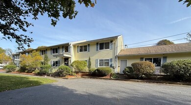


38 Lane Ave Unit B Clinton, MA 01510
Estimated payment $1,837/month
Highlights
- Medical Services
- Wood Flooring
- Community Pool
- Open Floorplan
- Solid Surface Countertops
- Stainless Steel Appliances
About This Home
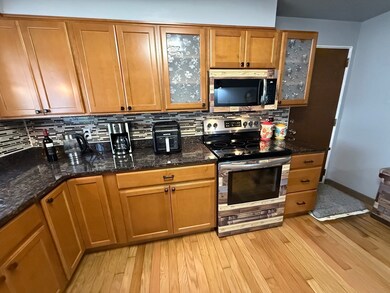
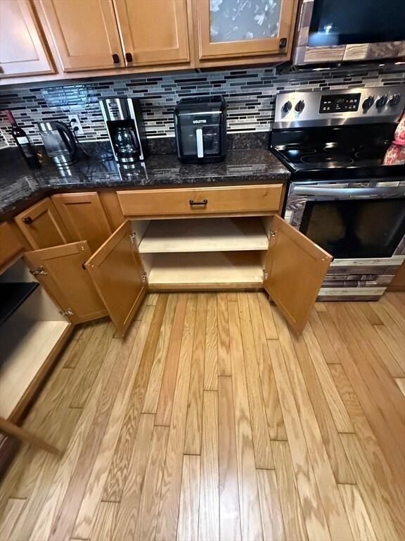
Welcome to 38 Lane Avenue! This condominium style home presents the best of single level living and is nestled in a beautiful neighborhood but still close to all that Clinton has to offer. Don't miss this outstanding opportunity into home ownership with this beautifully updated 2 bedroom unit featuring a modern and open floor plan and beaming with natural light. The kitchen boasts custom cabinetry, granite countertops, stainless steel appliances and hardwood floors which flow seamlessly into the large sun splashed living room. The hallway extends to two generous sized bedrooms with ample closet space, a double linen closet and an updated full bath. There's an assigned extra storage space in the front lobby, in-building laundry and plenty of parking. All of this and MORE at an affordable and attainable price. This home is turn-key ready and one not to be missed!
Open House Schedule
-
Saturday, November 01, 202512:00 to 1:30 pm11/1/2025 12:00:00 PM +00:0011/1/2025 1:30:00 PM +00:00Add to Calendar
Property Details
Home Type
- Condominium
Est. Annual Taxes
- $2,624
Year Built
- Built in 1975 | Remodeled
HOA Fees
- $308 Monthly HOA Fees
Home Design
- Entry on the 1st floor
- Frame Construction
- Blown Fiberglass Insulation
- Shingle Roof
Interior Spaces
- 770 Sq Ft Home
- 1-Story Property
- Open Floorplan
- Light Fixtures
- Insulated Windows
- Dining Area
Kitchen
- Range
- Microwave
- Dishwasher
- Stainless Steel Appliances
- Solid Surface Countertops
Flooring
- Wood
- Ceramic Tile
- Vinyl
Bedrooms and Bathrooms
- 2 Bedrooms
- 1 Full Bathroom
- Bathtub with Shower
Parking
- 2 Car Parking Spaces
- Paved Parking
- Open Parking
- Off-Street Parking
Schools
- Clinton Elementary School
- Clinton Middle School
- Clinton High School
Utilities
- Window Unit Cooling System
- 2 Heating Zones
- Heating Available
Additional Features
- Rain Gutters
- Two or More Common Walls
- Property is near schools
Listing and Financial Details
- Assessor Parcel Number M:0113 B:2553 L:0038B,4702132
Community Details
Overview
- Association fees include water, sewer, insurance, maintenance structure, ground maintenance, snow removal
- 8 Units
- Low-Rise Condominium
- Chaudemont Condominiums Community
Amenities
- Medical Services
- Common Area
- Shops
- Laundry Facilities
- Community Storage Space
Recreation
- Community Pool
- Park
Pet Policy
- Pets Allowed
Map
Home Values in the Area
Average Home Value in this Area
Tax History
| Year | Tax Paid | Tax Assessment Tax Assessment Total Assessment is a certain percentage of the fair market value that is determined by local assessors to be the total taxable value of land and additions on the property. | Land | Improvement |
|---|---|---|---|---|
| 2025 | $2,624 | $197,300 | $0 | $197,300 |
| 2024 | $2,593 | $197,300 | $0 | $197,300 |
| 2023 | $2,479 | $185,400 | $0 | $185,400 |
| 2022 | $2,630 | $176,400 | $0 | $176,400 |
| 2021 | $2,581 | $161,900 | $0 | $161,900 |
| 2020 | $2,508 | $161,900 | $0 | $161,900 |
| 2019 | $2,288 | $143,600 | $0 | $143,600 |
| 2018 | $2,328 | $137,100 | $0 | $137,100 |
| 2017 | $2,103 | $119,000 | $0 | $119,000 |
| 2016 | $2,055 | $119,000 | $0 | $119,000 |
| 2015 | $1,904 | $114,300 | $0 | $114,300 |
| 2014 | $1,846 | $114,300 | $0 | $114,300 |
Property History
| Date | Event | Price | List to Sale | Price per Sq Ft |
|---|---|---|---|---|
| 10/29/2025 10/29/25 | For Sale | $249,900 | -- | $325 / Sq Ft |
Purchase History
| Date | Type | Sale Price | Title Company |
|---|---|---|---|
| Condominium Deed | $174,900 | None Available |
Mortgage History
| Date | Status | Loan Amount | Loan Type |
|---|---|---|---|
| Open | $8,745 | Second Mortgage Made To Cover Down Payment |
Source: MLS Property Information Network (MLS PIN)
MLS Number: 73448805
APN: CLIN-000113-002553-000038-B000000
Disclaimer: Certain information contained herein is derived from information provided by parties other than Homes.com. All information provided is deemed reliable, but is not guaranteed to be accurate and should be independently verified.
![]() The property listing data and information, or the Images, set forth herein were provided to MLS Property Information Network, Inc. from third party sources, including sellers, lessors and public records, and were compiled by MLS Property Information Network, Inc. The property listing data and information, and the Images, are for the personal, non-commercial use of consumers having a good faith interest in purchasing or leasing listed properties of the type displayed to them and may not be used for any purpose other than to identify prospective properties which such consumers may have a good faith interest in purchasing or leasing. MLS Property Information Network, Inc. and its subscribers disclaim any and all representations and warranties as to the accuracy of the property listing data and information, or as to the accuracy of any of the Images, set forth herein.
The property listing data and information, or the Images, set forth herein were provided to MLS Property Information Network, Inc. from third party sources, including sellers, lessors and public records, and were compiled by MLS Property Information Network, Inc. The property listing data and information, and the Images, are for the personal, non-commercial use of consumers having a good faith interest in purchasing or leasing listed properties of the type displayed to them and may not be used for any purpose other than to identify prospective properties which such consumers may have a good faith interest in purchasing or leasing. MLS Property Information Network, Inc. and its subscribers disclaim any and all representations and warranties as to the accuracy of the property listing data and information, or as to the accuracy of any of the Images, set forth herein.
- 131 Main St
- 160 Park St
- 284 Main St
- 13 Simon Ct
- 403 Main St
- 125 Grove St
- 38 Norman St
- 286 Grove St Unit 286
- 180 Beacon St
- 40 Nashua St Unit 5
- 37 Grove St Unit 37
- 66 Oak St Unit 66
- 70 Oak St Unit 70
- 78 Oak St Unit 78
- 109 Oak St
- 19 Sprague Rd
- 55 Sterling St Unit 306
- 55 Sterling St Unit 314
- 89 1/2 Walnut St
- 51 Rigby St
- 60 Front St
- 40 Fairmount St Unit 3
- 165 Grove St Unit 1
- 165 Beacon St Unit 3
- 63 Union St
- 500 Main St
- 1-55 Green St
- 55 Green St Unit D-138
- 55 Green St Unit E-001
- 55 Green St Unit D-149
- 55 Green St Unit D-200
- 138 Water St Unit 2
- 274 Oak St Unit 3
- 43 Berlin St Unit 3
- 843 Main St Unit 104
- 843 Main St Unit 102
- 843 Main St
- 10 Spruce St Unit 2
- 13 Wittig Ct Unit 3
- 290 Berlin St
