
Seller's Agent in 2025
Hope Addorisio
Lamacchia Realty, Inc.
(978) 836-8434
2 in this area
58 Total Sales

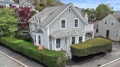
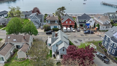


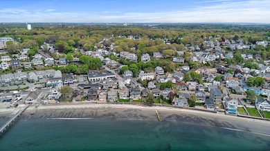
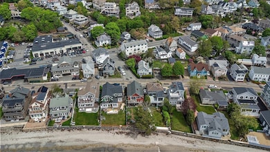
38 Puritan Road is nestled in one of Swampscott’s most desirable seaside neighborhoods. Just moments from the Beach, this character-filled 3 bed, 1.5 bath home offers endless potential for a buyer or investor with vision. The main level features a spacious living room, welcoming foyer, and a formal dining room that could be converted into a first-floor bedroom and a half bath. Upstairs, you'll find three bedrooms and a laundry room with the flexibility to become a bedroom or office and a full bath. With a newer heating system, some updated windows, and a tiered deck offering coastal views, this home presents a rare chance to reimagine and restore a classic just steps from the sand. Showings Showings begin at the commuter open house Thursday, July 10th 5:00pm-6:30pm, Saturday 12th &13th 11:00am-1:00pm.
| Date | Type | Sale Price | Title Company |
|---|---|---|---|
| Quit Claim Deed | $589,900 | -- | |
| Quit Claim Deed | -- | -- | |
| Deed | $180,000 | -- |
| Date | Status | Loan Amount | Loan Type |
|---|---|---|---|
| Open | $840,000 | New Conventional | |
| Previous Owner | $144,000 | Purchase Money Mortgage |
| Date | Event | Price | List to Sale | Price per Sq Ft |
|---|---|---|---|---|
| 09/18/2025 09/18/25 | Sold | $589,900 | 0.0% | $383 / Sq Ft |
| 07/15/2025 07/15/25 | Pending | -- | -- | -- |
| 07/08/2025 07/08/25 | For Sale | $589,900 | -- | $383 / Sq Ft |
| Year | Tax Paid | Tax Assessment Tax Assessment Total Assessment is a certain percentage of the fair market value that is determined by local assessors to be the total taxable value of land and additions on the property. | Land | Improvement |
|---|---|---|---|---|
| 2025 | $7,934 | $691,700 | $383,600 | $308,100 |
| 2024 | $7,643 | $665,200 | $359,200 | $306,000 |
| 2023 | $7,191 | $612,500 | $326,500 | $286,000 |
| 2022 | $6,785 | $528,800 | $277,500 | $251,300 |
| 2021 | $6,548 | $474,500 | $228,600 | $245,900 |
| 2020 | $6,734 | $470,900 | $228,600 | $242,300 |
| 2019 | $6,630 | $436,200 | $212,200 | $224,000 |
| 2018 | $6,827 | $426,700 | $212,200 | $214,500 |
| 2017 | $6,760 | $387,400 | $189,800 | $197,600 |
| 2016 | $6,714 | $387,400 | $189,800 | $197,600 |
| 2015 | $6,644 | $387,400 | $189,800 | $197,600 |
| 2014 | $6,480 | $346,500 | $163,300 | $183,200 |
Seller's Agent in 2025
Hope Addorisio
Lamacchia Realty, Inc.
(978) 836-8434
2 in this area
58 Total Sales
Source: MLS Property Information Network (MLS PIN)
MLS Number: 73401270
APN: SWAM-000019-000190
Disclaimer: Certain information contained herein is derived from information provided by parties other than Homes.com. All information provided is deemed reliable, but is not guaranteed to be accurate and should be independently verified.
![]() The property listing data and information, or the Images, set forth herein were provided to MLS Property Information Network, Inc. from third party sources, including sellers, lessors and public records, and were compiled by MLS Property Information Network, Inc. The property listing data and information, and the Images, are for the personal, non-commercial use of consumers having a good faith interest in purchasing or leasing listed properties of the type displayed to them and may not be used for any purpose other than to identify prospective properties which such consumers may have a good faith interest in purchasing or leasing. MLS Property Information Network, Inc. and its subscribers disclaim any and all representations and warranties as to the accuracy of the property listing data and information, or as to the accuracy of any of the Images, set forth herein.
The property listing data and information, or the Images, set forth herein were provided to MLS Property Information Network, Inc. from third party sources, including sellers, lessors and public records, and were compiled by MLS Property Information Network, Inc. The property listing data and information, and the Images, are for the personal, non-commercial use of consumers having a good faith interest in purchasing or leasing listed properties of the type displayed to them and may not be used for any purpose other than to identify prospective properties which such consumers may have a good faith interest in purchasing or leasing. MLS Property Information Network, Inc. and its subscribers disclaim any and all representations and warranties as to the accuracy of the property listing data and information, or as to the accuracy of any of the Images, set forth herein.