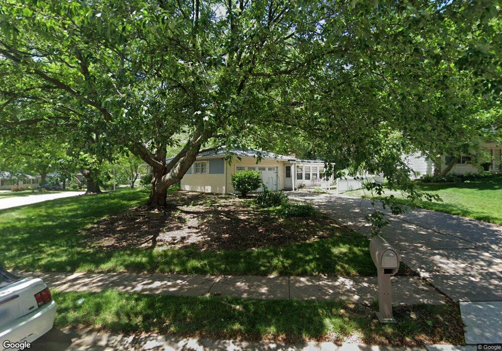
3806 Lorton Ave Davenport, IA 52807
North Side NeighborhoodEstimated Value: $267,000 - $298,000
3
Beds
2
Baths
1,730
Sq Ft
$164/Sq Ft
Est. Value
About This Home
This home is located at 3806 Lorton Ave, Davenport, IA 52807 and is currently estimated at $284,544, approximately $164 per square foot. 3806 Lorton Ave is a home located in Scott County with nearby schools including Jones Park Elementary School, Eisenhower Elementary School, and Casey County Middle School.
Ownership History
Date
Name
Owned For
Owner Type
Purchase Details
Closed on
Mar 9, 2011
Sold by
Rensberger Michael L and Sothmann Patti A
Bought by
Sothmann Patti A
Current Estimated Value
Create a Home Valuation Report for This Property
The Home Valuation Report is an in-depth analysis detailing your home's value as well as a comparison with similar homes in the area
Home Values in the Area
Average Home Value in this Area
Purchase History
| Date | Buyer | Sale Price | Title Company |
|---|---|---|---|
| Sothmann Patti A | -- | None Available |
Source: Public Records
Tax History Compared to Growth
Tax History
| Year | Tax Paid | Tax Assessment Tax Assessment Total Assessment is a certain percentage of the fair market value that is determined by local assessors to be the total taxable value of land and additions on the property. | Land | Improvement |
|---|---|---|---|---|
| 2025 | $4,114 | $267,190 | $58,320 | $208,870 |
| 2024 | $4,250 | $254,130 | $58,320 | $195,810 |
| 2023 | $4,668 | $254,130 | $58,320 | $195,810 |
| 2022 | $4,526 | $227,410 | $52,760 | $174,650 |
| 2021 | $4,526 | $219,880 | $52,760 | $167,120 |
| 2020 | $4,292 | $206,330 | $52,760 | $153,570 |
| 2019 | $4,190 | $195,290 | $52,760 | $142,530 |
| 2018 | $3,940 | $195,290 | $52,760 | $142,530 |
| 2017 | $4,084 | $188,160 | $52,760 | $135,400 |
| 2016 | $3,930 | $188,160 | $0 | $0 |
| 2015 | $3,930 | $187,460 | $0 | $0 |
| 2014 | $3,970 | $187,460 | $0 | $0 |
| 2013 | $3,896 | $0 | $0 | $0 |
| 2012 | -- | $187,380 | $50,210 | $137,170 |
Source: Public Records
Map
Nearby Homes
- 2506 E 35th Street Ct
- 2501 E 34th Street Ct
- 4005 Forest Rd
- 3315 Fairhaven Rd
- 4230 Jersey Ridge Rd
- 3000 E 32nd St Unit 14
- 2805 Carriage Hill Dr
- 3044 Jersey Ridge Rd
- 2919 E 44th Ct
- 2586 E George Washington Blvd
- 4406 Belle Ave
- 2318 E 46th St
- 2203 E 46th St
- 4324 Spring St
- 2916 E 45th Ct
- 2321 E 47th St
- 2924 E 45th Ct
- 1804 E 31st St
- 3324 Eastern Ave
- 2706 Ridgewood Ave
- 3816 Lorton Ave
- 2606 E 38th St
- 3815 Woodland Ct
- 3824 Lorton Ave
- 3734 Lorton Ave
- 3745 Lorton Ave
- 3811 Lorton Ave
- 3821 Lorton Ave
- 3739 Lorton Ave
- 3823 Woodland Ct
- 2607 E 38th St
- 3729 Lorton Ave
- 3904 Lorton Ave
- 2529 E 38th St
- 3910 Lorton Ave
- 2522 E 38th St
- 3829 Woodland Ct
- 3907 Lorton Ave
- 3718 Lorton Ave
- 3820 Kenwood Ave