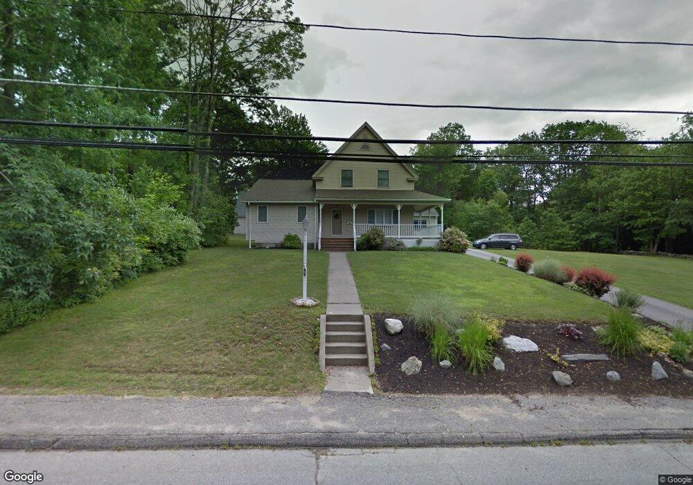
381 Pakachoag St Auburn, MA 01501
Downtown Auburn NeighborhoodEstimated Value: $515,000 - $734,000
4
Beds
3
Baths
2,842
Sq Ft
$225/Sq Ft
Est. Value
About This Home
This home is located at 381 Pakachoag St, Auburn, MA 01501 and is currently estimated at $639,459, approximately $225 per square foot. 381 Pakachoag St is a home located in Worcester County with nearby schools including Auburn Senior High School and Shrewsbury Montessori School - Auburn Campus.
Ownership History
Date
Name
Owned For
Owner Type
Purchase Details
Closed on
May 25, 2011
Sold by
Johnson Denise A
Bought by
Pitro Kristie M
Current Estimated Value
Purchase Details
Closed on
Mar 29, 1977
Bought by
Keyes Denise A
Create a Home Valuation Report for This Property
The Home Valuation Report is an in-depth analysis detailing your home's value as well as a comparison with similar homes in the area
Home Values in the Area
Average Home Value in this Area
Purchase History
| Date | Buyer | Sale Price | Title Company |
|---|---|---|---|
| Pitro Kristie M | -- | -- | |
| Keyes Denise A | -- | -- |
Source: Public Records
Mortgage History
| Date | Status | Borrower | Loan Amount |
|---|---|---|---|
| Previous Owner | Keyes Denise A | $50,000 |
Source: Public Records
Tax History Compared to Growth
Tax History
| Year | Tax Paid | Tax Assessment Tax Assessment Total Assessment is a certain percentage of the fair market value that is determined by local assessors to be the total taxable value of land and additions on the property. | Land | Improvement |
|---|---|---|---|---|
| 2025 | $87 | $611,600 | $146,700 | $464,900 |
| 2024 | $8,697 | $582,500 | $142,800 | $439,700 |
| 2023 | $8,670 | $546,000 | $129,900 | $416,100 |
| 2022 | $8,094 | $481,200 | $129,900 | $351,300 |
| 2021 | $41 | $431,800 | $114,700 | $317,100 |
| 2020 | $9,746 | $414,100 | $114,700 | $299,400 |
| 2019 | $7,073 | $384,000 | $113,400 | $270,600 |
| 2018 | $597 | $375,700 | $106,200 | $269,500 |
| 2017 | $6,716 | $366,200 | $96,900 | $269,300 |
| 2016 | $5,617 | $310,500 | $99,600 | $210,900 |
| 2015 | $5,276 | $305,700 | $99,600 | $206,100 |
| 2014 | $5,165 | $298,700 | $95,000 | $203,700 |
Source: Public Records
Map
Nearby Homes
- 375 Pakachoag St
- 380 Pakachoag St
- 384 Pakachoag St
- 390 Pakachoag St
- 376 Pakachoag St
- 393 Pakachoag St
- 379 Pakachoag St
- 355 Pakachoag St
- 352 Pakachoag St
- 395 Pakachoag St
- 353 Pakachoag St
- 2 Silver St Unit LADY
- 2 Silver St Unit LADY
- 6 Lady Slipper Ln Unit 1
- 2 Lady Slipper Ln Unit 2
- 4 Lady Slipper Ln Unit 2
- 1 Victoria Dr Unit 1
- 5 Lady Slipper Ln Unit 2
- 6 Lady Slipper Ln Unit 3
- 1 Lady Slipper Ln Unit 1