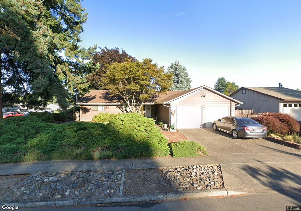
381 S 5th Ave Cornelius, OR 97113
Estimated Value: $470,000 - $490,000
3
Beds
2
Baths
1,678
Sq Ft
$286/Sq Ft
Est. Value
About This Home
This home is located at 381 S 5th Ave, Cornelius, OR 97113 and is currently estimated at $480,301, approximately $286 per square foot. 381 S 5th Ave is a home located in Washington County with nearby schools including Echo Shaw Elementary School, Neil Armstrong Middle School, and Tom McCall Upper Elementary School.
Ownership History
Date
Name
Owned For
Owner Type
Purchase Details
Closed on
Oct 26, 2022
Sold by
Shallanberger Gary L
Bought by
Knight Shallanberger Living Trust
Current Estimated Value
Purchase Details
Closed on
Oct 14, 1998
Sold by
Johnson Jeffrey L
Bought by
Gee Nancy R and Shallanberger Gary L
Home Financials for this Owner
Home Financials are based on the most recent Mortgage that was taken out on this home.
Original Mortgage
$135,850
Interest Rate
6.79%
Create a Home Valuation Report for This Property
The Home Valuation Report is an in-depth analysis detailing your home's value as well as a comparison with similar homes in the area
Purchase History
| Date | Buyer | Sale Price | Title Company |
|---|---|---|---|
| Knight Shallanberger Living Trust | -- | -- | |
| Gee Nancy R | $143,000 | Oregon Title Insurance Co |
Source: Public Records
Mortgage History
| Date | Status | Borrower | Loan Amount |
|---|---|---|---|
| Previous Owner | Gee Nancy R | $135,850 |
Source: Public Records
Tax History
| Year | Tax Paid | Tax Assessment Tax Assessment Total Assessment is a certain percentage of the fair market value that is determined by local assessors to be the total taxable value of land and additions on the property. | Land | Improvement |
|---|---|---|---|---|
| 2026 | $4,120 | $237,130 | -- | -- |
| 2025 | $4,120 | $230,230 | -- | -- |
| 2024 | $3,762 | $223,530 | -- | -- |
| 2023 | $3,762 | $217,020 | $0 | $0 |
| 2022 | $3,334 | $217,020 | $0 | $0 |
| 2021 | $3,294 | $204,570 | $0 | $0 |
| 2020 | $3,282 | $198,620 | $0 | $0 |
| 2019 | $3,210 | $192,840 | $0 | $0 |
| 2018 | $3,111 | $187,230 | $0 | $0 |
| 2017 | $3,015 | $181,780 | $0 | $0 |
| 2016 | $2,930 | $176,490 | $0 | $0 |
| 2015 | $2,757 | $171,350 | $0 | $0 |
| 2014 | $2,662 | $166,360 | $0 | $0 |
Source: Public Records
Map
Nearby Homes
- 332 S Tarrybrook Dr
- 253 S Tarrybrook Cir
- 961 S 4th Ave
- 1509 Centennial Cir
- 1504 Frontier Cir
- 312 S Magnolia St
- 1506 Pioneer Cir
- 4403 Wagon Wheel Cir
- 1100 S Ivy St
- 904 S Magnolia St
- 1302 Pioneer Way
- 1830 Tamarack Way
- 369 S 16th Ave
- 1721 Sequoia Ct
- 570 N 10th St Unit 29
- 3831 Pacific Ave Unit D5
- 3831 Pacific Ave Unit D2
- 570 N 10th Ave Unit 2
- 570 N 10th Ave Unit 6
- 570 N 10th Ave Unit 80
- 375 S 5th Ave
- 450 S Dogwood St
- 467 S Cherry Dr
- 465 S Dogwood St
- 433 S Cherry Dr
- 500 S Dogwood St
- 360 S 5th Ave
- 435 S Dogwood St
- 400 S Dogwood St
- 410 S 5th Ave
- 370 S 4th Ave
- 527 S 5th Ave
- 320 S 4th Place
- 323 S 5th Ave
- 405 S Dogwood St
- 346 S 5th Ave
- 520 S 4th Ave
- 545 S Dogwood St
- 580 S Dogwood St
- 325 S 4th Place
Your Personal Tour Guide
Ask me questions while you tour the home.