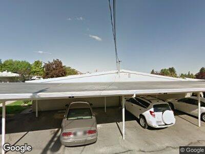
381 W 400 N Unit 10 Bountiful, UT 84010
Estimated Value: $304,000 - $335,398
2
Beds
2
Baths
1,380
Sq Ft
$233/Sq Ft
Est. Value
About This Home
This home is located at 381 W 400 N Unit 10, Bountiful, UT 84010 and is currently estimated at $321,350, approximately $232 per square foot. 381 W 400 N Unit 10 is a home located in Davis County with nearby schools including Meadowbrook Elementary School, Bountiful Junior High School, and Bountiful High School.
Ownership History
Date
Name
Owned For
Owner Type
Purchase Details
Closed on
Sep 16, 2022
Sold by
Wendi Allen
Bought by
Wendi Allen Trust
Current Estimated Value
Purchase Details
Closed on
Aug 31, 2022
Sold by
Bird Kathleen L
Bought by
Allen Wendi
Purchase Details
Closed on
Jul 18, 2008
Sold by
Seiler M Lorraine
Bought by
Bird Kathleen L
Home Financials for this Owner
Home Financials are based on the most recent Mortgage that was taken out on this home.
Original Mortgage
$114,400
Interest Rate
6.31%
Mortgage Type
Purchase Money Mortgage
Purchase Details
Closed on
Sep 24, 2007
Sold by
Seiler M Lorraine
Bought by
Seiler M Lorraine and The M Lorraine Seiler Family Trust
Purchase Details
Closed on
Sep 4, 2007
Sold by
Seiler M Lorraine
Bought by
The M Lorraine Seiler Family Trust
Purchase Details
Closed on
Jan 11, 2007
Sold by
Miller Michael B and Miller Susan H
Bought by
Seiler M Lorraine
Home Financials for this Owner
Home Financials are based on the most recent Mortgage that was taken out on this home.
Original Mortgage
$104,800
Interest Rate
6.12%
Mortgage Type
Purchase Money Mortgage
Purchase Details
Closed on
Aug 7, 2003
Sold by
Bryson Darrel and Blackburn Lorene
Bought by
Miller Michael B and Miller Susan H
Home Financials for this Owner
Home Financials are based on the most recent Mortgage that was taken out on this home.
Original Mortgage
$67,525
Interest Rate
5.29%
Mortgage Type
Purchase Money Mortgage
Purchase Details
Closed on
Nov 26, 1997
Sold by
Leak Lorene B
Bought by
Leak Lorene B and Bryson Darrell
Purchase Details
Closed on
Jul 12, 1996
Sold by
Pascoe Carma M and Pascoe Wayne A
Bought by
Leak Lorene B
Purchase Details
Closed on
Jun 4, 1996
Sold by
Pascoe Carma M and Pascoe Wayne A
Bought by
Leak Lorene B
Purchase Details
Closed on
Dec 28, 1995
Sold by
Hamilton Imogene and Hamilton Gene
Bought by
Pascoe Carma M and Pascoe Wayne A
Create a Home Valuation Report for This Property
The Home Valuation Report is an in-depth analysis detailing your home's value as well as a comparison with similar homes in the area
Home Values in the Area
Average Home Value in this Area
Purchase History
| Date | Buyer | Sale Price | Title Company |
|---|---|---|---|
| Wendi Allen Trust | -- | Us Title | |
| Allen Wendi | -- | -- | |
| Bird Kathleen L | -- | First American Title | |
| Seiler M Lorraine | -- | None Available | |
| The M Lorraine Seiler Family Trust | -- | None Available | |
| Seiler M Lorraine | -- | Bonneville Superior Title Co | |
| Miller Michael B | -- | Mountain View Title & Escrow | |
| Leak Lorene B | -- | -- | |
| Leak Lorene B | -- | Western States Title Company | |
| Leak Lorene B | -- | Western States Title Company | |
| Pascoe Carma M | -- | -- |
Source: Public Records
Mortgage History
| Date | Status | Borrower | Loan Amount |
|---|---|---|---|
| Previous Owner | Bird Katheleen L | $111,200 | |
| Previous Owner | Bird Kathleen L | $114,400 | |
| Previous Owner | Seiler M Lorraine | $104,800 | |
| Previous Owner | Miller Michael B | $67,525 | |
| Closed | Miller Michael B | $12,750 |
Source: Public Records
Tax History Compared to Growth
Tax History
| Year | Tax Paid | Tax Assessment Tax Assessment Total Assessment is a certain percentage of the fair market value that is determined by local assessors to be the total taxable value of land and additions on the property. | Land | Improvement |
|---|---|---|---|---|
| 2024 | $1,621 | $154,550 | $54,450 | $100,100 |
| 2023 | $1,588 | $275,000 | $93,000 | $182,000 |
| 2022 | $1,511 | $143,000 | $32,450 | $110,550 |
| 2021 | $1,417 | $205,000 | $46,000 | $159,000 |
| 2020 | $1,234 | $179,000 | $42,600 | $136,400 |
| 2019 | $1,236 | $175,000 | $39,000 | $136,000 |
| 2018 | $1,081 | $150,000 | $55,000 | $95,000 |
| 2016 | $862 | $64,295 | $13,750 | $50,545 |
| 2015 | $829 | $58,291 | $13,750 | $44,541 |
| 2014 | $888 | $64,706 | $18,333 | $46,373 |
| 2013 | -- | $65,648 | $17,600 | $48,048 |
Source: Public Records
Map
Nearby Homes
- 401 W 400 N Unit 52
- 379 W 400 N Unit 7
- 395 W 400 N Unit 39
- 380 N 500 W Unit 202
- 290 N 500 W Unit 108
- 336 W 200 N
- 260 W 400 N
- 499 N 200 W Unit 8
- 499 N 200 W Unit 19
- 314 W Center St Unit D135
- 314 W Center St Unit F118
- 314 W Center St Unit D141
- 571 N 200 W
- 147 W 25 N Unit 5
- 131 W 25 N Unit 4
- 173 W 300 N
- 819 N 225 W
- 235 W 1000 N
- 920 N 200 W
- 600 W 1000 N
- 381 W 400 N Unit 12
- 381 W 400 N Unit 11
- 381 W 400 N Unit 10
- 381 W 400 N Unit 9
- 383 W 400 N Unit 16
- 383 W 400 N Unit 15
- 383 W 400 N Unit 14
- 383 W 400 N Unit 13
- 383 W 400 N
- 379 W 400 N Unit 8
- 379 W 400 N
- 379 W 400 N Unit 6
- 379 W 400 N Unit 5
- 403 W 400 N Unit 4
- 403 W 400 N Unit 3
- 403 W 400 N Unit 2
- 403 W 400 N Unit 1
- 403 W 400 N
- 349 N 350 W
- 385 W 400 N Unit 20