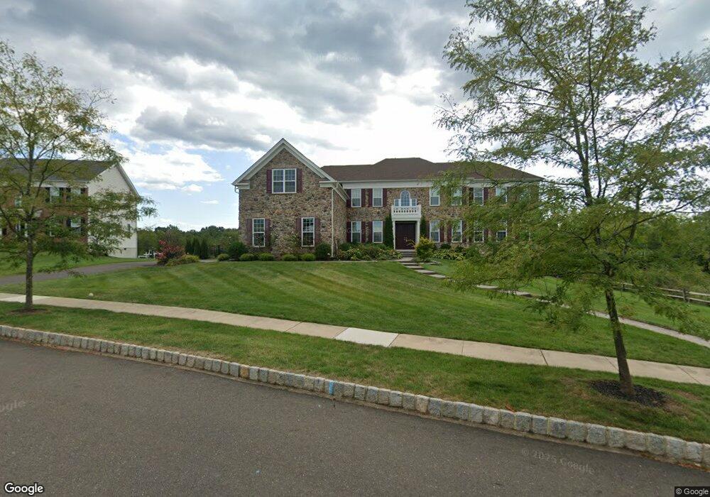
3811 Parkside Dr Furlong, PA 18925
Estimated Value: $1,733,250 - $1,793,000
5
Beds
6
Baths
6,231
Sq Ft
$283/Sq Ft
Est. Value
About This Home
This home is located at 3811 Parkside Dr, Furlong, PA 18925 and is currently estimated at $1,766,083, approximately $283 per square foot. 3811 Parkside Dr is a home with nearby schools including Bridge Valley Elementary School, Holicong Middle School, and Central Bucks High School - East.
Ownership History
Date
Name
Owned For
Owner Type
Purchase Details
Closed on
Dec 6, 2018
Sold by
Toll Xi Lp
Bought by
Pollock Jeff and Zhu Sijia
Current Estimated Value
Home Financials for this Owner
Home Financials are based on the most recent Mortgage that was taken out on this home.
Original Mortgage
$750,000
Outstanding Balance
$647,822
Interest Rate
3.87%
Mortgage Type
Adjustable Rate Mortgage/ARM
Estimated Equity
$1,118,261
Purchase Details
Closed on
Aug 10, 2006
Sold by
Smith Benjamin C and Russell E & Kathryn G Smith Tr
Bought by
Toll Pa Xi Lp
Create a Home Valuation Report for This Property
The Home Valuation Report is an in-depth analysis detailing your home's value as well as a comparison with similar homes in the area
Home Values in the Area
Average Home Value in this Area
Purchase History
| Date | Buyer | Sale Price | Title Company |
|---|---|---|---|
| Pollock Jeff | $1,211,231 | Westminster Abstract | |
| Toll Pa Xi Lp | $1,228,020 | None Available |
Source: Public Records
Mortgage History
| Date | Status | Borrower | Loan Amount |
|---|---|---|---|
| Open | Pollock Jeff | $750,000 |
Source: Public Records
Tax History Compared to Growth
Tax History
| Year | Tax Paid | Tax Assessment Tax Assessment Total Assessment is a certain percentage of the fair market value that is determined by local assessors to be the total taxable value of land and additions on the property. | Land | Improvement |
|---|---|---|---|---|
| 2025 | $16,740 | $102,820 | $11,660 | $91,160 |
| 2024 | $16,740 | $102,820 | $11,660 | $91,160 |
| 2023 | $16,173 | $102,820 | $11,660 | $91,160 |
| 2022 | $15,979 | $102,820 | $11,660 | $91,160 |
| 2021 | $15,788 | $102,820 | $11,660 | $91,160 |
| 2020 | $15,788 | $102,820 | $11,660 | $91,160 |
| 2019 | $15,685 | $102,820 | $11,660 | $91,160 |
| 2018 | $1,779 | $11,660 | $11,660 | $0 |
| 2017 | $1,764 | $11,660 | $11,660 | $0 |
| 2016 | -- | $11,660 | $11,660 | $0 |
Source: Public Records
Map
Nearby Homes
- 1221 Creek Rd
- 214 Dove Ct
- 377 Spring Meadow Cir
- 158 Grouse Cir
- 4549 Lower Mountain Rd
- 941 Penns Park
- 191 Cardinal Ct S
- 183 Spring Meadow Cir
- 147 Raven Ct
- 148 Raven Ct
- 1515 Sugar Bottom Rd
- 0 Old York Rd Unit PABU2103356
- 495 Goldenrod Crossing W
- 529 Honeysuckle Ct
- 1948 Forest Grove Rd
- 561 Spring Meadow Cir
- 92 Acorn Ct E
- 4448 Lower Mountain Rd
- 4697 Smith Rd
- 1341 Durham Rd
- 3817 Parkside Dr
- 3826 Parkside Dr
- 3823 Parkside Dr
- 3846 Parkside Dr
- 3829 Parkside Dr
- 3856 Parkside Dr
- 3839 Parkside Dr
- 3849 Parkside Dr
- 3862 Parkside Dr
- 3859 Parkside Dr
- 3869 Parkside Dr
- 3814 Dark Hollow Rd Unit BARN2
- 3814 Dark Hollow Rd
- 3866 Parkside Dr
- 3879 Parkside Dr
- 3889 Parkside Dr
- 3874 Parkside Dr
- 3585 Dark Hollow Rd
- 3893 Parkside Dr
- 3882 Parkside Dr