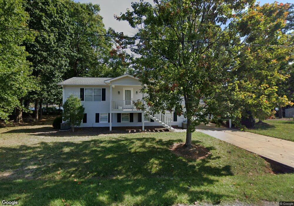
3816 Dock Side Ln Sherrills Ford, NC 28673
Estimated Value: $643,000 - $1,095,000
3
Beds
2
Baths
2,200
Sq Ft
$418/Sq Ft
Est. Value
About This Home
This home is located at 3816 Dock Side Ln, Sherrills Ford, NC 28673 and is currently estimated at $919,654, approximately $418 per square foot. 3816 Dock Side Ln is a home located in Catawba County with nearby schools including Bandys High School, Sherrills Ford Elementary School, and Mill Creek Middle School.
Ownership History
Date
Name
Owned For
Owner Type
Purchase Details
Closed on
Aug 1, 2011
Sold by
Surratt Derrick Lynn and Surratt Kimberly Ann
Bought by
Surratt Lakeside Property Llc
Current Estimated Value
Purchase Details
Closed on
Jul 21, 2006
Sold by
Surratt W Todd and Surratt Carol Vaughn
Bought by
Surratt Christopher Brannon and Surratt Derrick Lynn
Purchase Details
Closed on
Jan 1, 1979
Bought by
Surratt Walter Wesley and Surratt Rachel
Create a Home Valuation Report for This Property
The Home Valuation Report is an in-depth analysis detailing your home's value as well as a comparison with similar homes in the area
Home Values in the Area
Average Home Value in this Area
Purchase History
| Date | Buyer | Sale Price | Title Company |
|---|---|---|---|
| Surratt Lakeside Property Llc | -- | None Available | |
| Surratt Christopher Brannon | $65,000 | None Available | |
| Surratt Walter Wesley | $25,000 | -- |
Source: Public Records
Tax History Compared to Growth
Tax History
| Year | Tax Paid | Tax Assessment Tax Assessment Total Assessment is a certain percentage of the fair market value that is determined by local assessors to be the total taxable value of land and additions on the property. | Land | Improvement |
|---|---|---|---|---|
| 2025 | $3,861 | $784,000 | $323,100 | $460,900 |
| 2024 | $3,861 | $784,000 | $323,100 | $460,900 |
| 2023 | $3,706 | $372,100 | $147,700 | $224,400 |
| 2022 | $2,623 | $372,100 | $147,700 | $224,400 |
| 2021 | $2,623 | $372,100 | $147,700 | $224,400 |
| 2020 | $2,623 | $372,100 | $147,700 | $224,400 |
| 2019 | $2,623 | $372,100 | $0 | $0 |
| 2018 | $2,556 | $373,200 | $147,700 | $225,500 |
| 2017 | $2,556 | $0 | $0 | $0 |
| 2016 | $2,448 | $0 | $0 | $0 |
| 2015 | $2,176 | $373,160 | $147,700 | $225,460 |
| 2014 | $2,176 | $362,700 | $147,700 | $215,000 |
Source: Public Records
Map
Nearby Homes
- 6997 Waterstone Dr
- 3861 Swanson Rd
- 939 Exeter Dr
- 916 Exeter Dr
- 3915 Chevlot Hills Rd
- 0 Chevlot Hills Rd
- 4159 Todd St
- 7326 Right Angle St
- 7264 Right Angle St
- 3930 Norman View Dr
- 4278 Harbor Ln
- 3678 Norman View Dr
- 3835 Norman View Dr
- 7850 Fountaingrass Ln
- 7250 Little Mountain Rd
- 3538 Chubs Ln
- 3578 Big Timber Dr
- 3565 Big Timber Dr
- 000 Slanting Bridge Rd
- 3748 Landmark Dr
- 3833 Dockside Ln
- 3833 Dock Side Ln
- 3830 Dock Side Ln
- 3800 Dock Side Ln
- 7505 Matchpoint
- 3788 Dock Side Ln
- 3846 Dock Side Ln
- 3781 Dock Side Ln
- 3778 Dock Side Ln
- 3852 Dock Side Ln
- 7464 Matchpoint
- 7474 Matchpoint
- 3768 Dock Side Ln
- 3955 Burton St
- 3758 Dock Side Ln
- 3745 Dock Side Ln
- 3876 Swanson Rd
- 4306 Reed Creek Dr
- 4323 Reed Creek Dr
- 4302 Reed Creek Dr