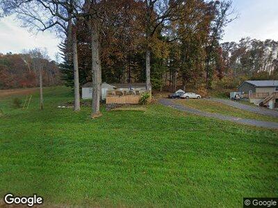
3817 State Route 220 Waverly, OH 45690
Estimated Value: $147,603 - $184,000
3
Beds
1
Bath
952
Sq Ft
$168/Sq Ft
Est. Value
About This Home
This home is located at 3817 State Route 220, Waverly, OH 45690 and is currently estimated at $159,901, approximately $167 per square foot. 3817 State Route 220 is a home located in Pike County with nearby schools including Waverly Primary School, Waverly Intermediate School, and Waverly Junior High School.
Ownership History
Date
Name
Owned For
Owner Type
Purchase Details
Closed on
Oct 6, 2020
Sold by
Laverick David W and Laverick Janet
Bought by
Estep Emil E and Estep Rene L
Current Estimated Value
Purchase Details
Closed on
Mar 13, 2006
Sold by
Secrectary Of Veterans Affiars
Bought by
Laverick David W and Laverick Janet
Home Financials for this Owner
Home Financials are based on the most recent Mortgage that was taken out on this home.
Original Mortgage
$30,000
Interest Rate
6.33%
Mortgage Type
New Conventional
Create a Home Valuation Report for This Property
The Home Valuation Report is an in-depth analysis detailing your home's value as well as a comparison with similar homes in the area
Home Values in the Area
Average Home Value in this Area
Purchase History
| Date | Buyer | Sale Price | Title Company |
|---|---|---|---|
| Estep Emil E | $79,500 | Title First Agency Inc | |
| Laverick David W | -- | None Available |
Source: Public Records
Mortgage History
| Date | Status | Borrower | Loan Amount |
|---|---|---|---|
| Closed | Laverick David W | $30,000 |
Source: Public Records
Tax History Compared to Growth
Tax History
| Year | Tax Paid | Tax Assessment Tax Assessment Total Assessment is a certain percentage of the fair market value that is determined by local assessors to be the total taxable value of land and additions on the property. | Land | Improvement |
|---|---|---|---|---|
| 2024 | $1,318 | $39,080 | $19,180 | $19,900 |
| 2023 | $1,318 | $39,080 | $19,180 | $19,900 |
| 2022 | $1,214 | $31,520 | $16,720 | $14,800 |
| 2021 | $1,190 | $31,520 | $16,720 | $14,800 |
| 2020 | $1,193 | $31,520 | $16,720 | $14,800 |
| 2019 | $1,045 | $27,650 | $14,670 | $12,980 |
| 2018 | $1,037 | $27,650 | $14,670 | $12,980 |
| 2017 | $1,106 | $31,720 | $14,670 | $17,050 |
| 2016 | $844 | $21,860 | $5,750 | $16,110 |
| 2015 | $844 | $21,860 | $5,750 | $16,110 |
| 2014 | $815 | $21,860 | $5,750 | $16,110 |
| 2013 | $826 | $21,860 | $5,750 | $16,110 |
| 2012 | $848 | $21,860 | $5,750 | $16,110 |
Source: Public Records
Map
Nearby Homes
- 194 Ohio 551
- 678 Ohio 551
- 195 Lake Rd
- 0 Virginia Ln
- 954 Ohio 551
- 278 Lake Rd
- 0 Woodland Dr
- 291 Bevens Ln
- 1856 Fish And Game Rd
- 387 Bevens Ln
- 465 Bevens Ln
- 621 Ohio 551
- 1452 Ohio 551
- 000 Wells Jones Rd
- 644 Ohio 552
- 0 Gregg Rd
- 0 Ohio 552
- 3679 Buchanan Rd
- 0 Mt Tabor Rd Unit 23152534
- 0 Mt Tabor Rd Unit 11471820
- 3817 State Route 220
- 3817 Ohio 220
- 3783 State Route 220
- 3821 State Route 220
- 3821 Ohio 220
- 3875 Ohio 220
- 3849 Ohio 220
- 3849 State Route 220
- 3875 State Route 220
- 3883 State Route 220
- 3911 State Route 220
- 3929 State Route 220
- 3670 State Route 220
- 98 Fish And Game Rd
- 3627 State Route 220
- 3627 Ohio 220
- 3636 State Route 220
- 3930 State Route 220
- 3607 Ohio 220
- 3652 State Route 220
