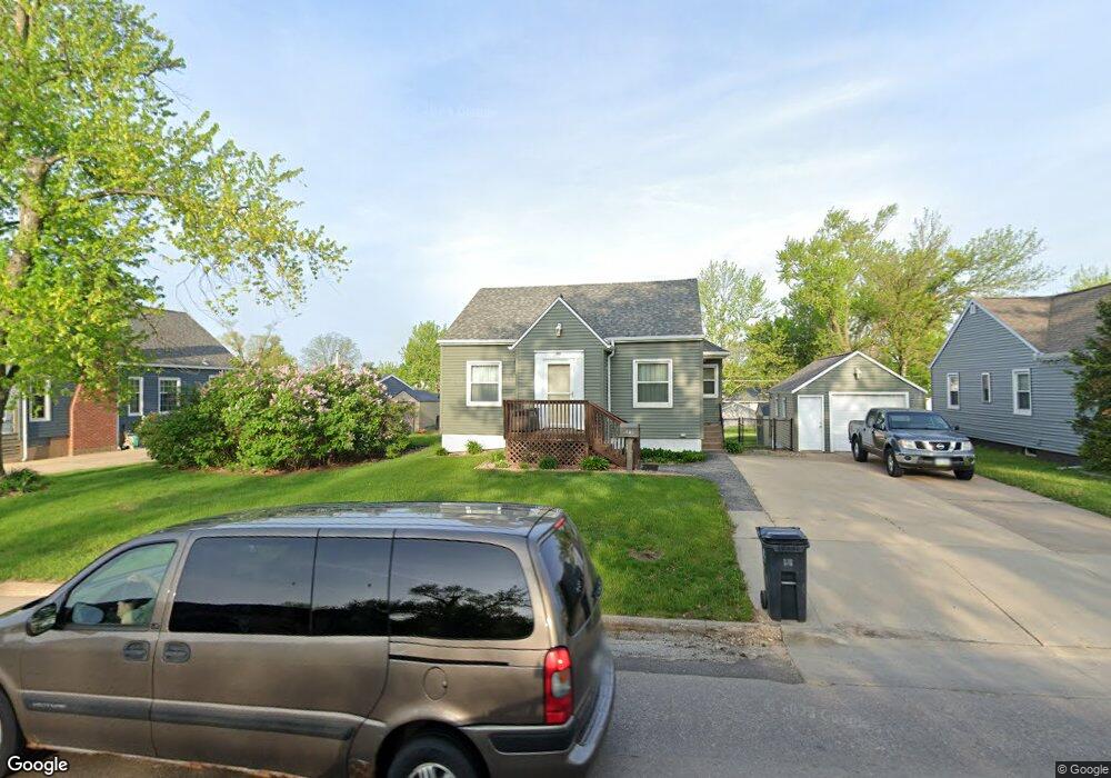
3818 C Ave NE Cedar Rapids, IA 52402
Kenwood Park NeighborhoodEstimated Value: $158,000 - $186,306
3
Beds
2
Baths
1,065
Sq Ft
$158/Sq Ft
Est. Value
About This Home
This home is located at 3818 C Ave NE, Cedar Rapids, IA 52402 and is currently estimated at $168,077, approximately $157 per square foot. 3818 C Ave NE is a home located in Linn County with nearby schools including Kenwood Leadership Academy, Franklin Middle School, and George Washington High School.
Ownership History
Date
Name
Owned For
Owner Type
Purchase Details
Closed on
Nov 24, 2009
Sold by
Mcclellan Aaron M and Mcclellan Kristine L
Bought by
Kitzman Terrence and Kitzman Terrence L
Current Estimated Value
Home Financials for this Owner
Home Financials are based on the most recent Mortgage that was taken out on this home.
Original Mortgage
$95,200
Outstanding Balance
$62,003
Interest Rate
4.95%
Mortgage Type
VA
Estimated Equity
$106,074
Purchase Details
Closed on
Oct 27, 2005
Sold by
Zahn Virginia Lee
Bought by
Mcclellan Aaron M and Mcclellan Kristine L
Home Financials for this Owner
Home Financials are based on the most recent Mortgage that was taken out on this home.
Original Mortgage
$85,490
Interest Rate
5.37%
Mortgage Type
Fannie Mae Freddie Mac
Create a Home Valuation Report for This Property
The Home Valuation Report is an in-depth analysis detailing your home's value as well as a comparison with similar homes in the area
Home Values in the Area
Average Home Value in this Area
Purchase History
| Date | Buyer | Sale Price | Title Company |
|---|---|---|---|
| Kitzman Terrence | $97,000 | None Available | |
| Mcclellan Aaron M | -- | -- |
Source: Public Records
Mortgage History
| Date | Status | Borrower | Loan Amount |
|---|---|---|---|
| Open | Kitzman Terrence | $95,200 | |
| Previous Owner | Mcclellan Aaron M | $85,490 |
Source: Public Records
Tax History Compared to Growth
Tax History
| Year | Tax Paid | Tax Assessment Tax Assessment Total Assessment is a certain percentage of the fair market value that is determined by local assessors to be the total taxable value of land and additions on the property. | Land | Improvement |
|---|---|---|---|---|
| 2025 | $2,858 | $184,900 | $37,900 | $147,000 |
| 2024 | $2,656 | $180,600 | $37,900 | $142,700 |
| 2023 | $2,656 | $180,600 | $37,900 | $142,700 |
| 2022 | $2,192 | $138,200 | $37,900 | $100,300 |
| 2021 | $2,216 | $118,200 | $30,300 | $87,900 |
| 2020 | $2,216 | $112,300 | $27,300 | $85,000 |
| 2019 | $1,974 | $103,400 | $24,200 | $79,200 |
| 2018 | $1,914 | $103,400 | $24,200 | $79,200 |
| 2017 | $2,031 | $98,900 | $24,200 | $74,700 |
| 2016 | $2,031 | $98,900 | $24,200 | $74,700 |
| 2015 | $2,051 | $99,720 | $24,240 | $75,480 |
| 2014 | $1,866 | $99,720 | $24,240 | $75,480 |
| 2013 | $1,820 | $99,720 | $24,240 | $75,480 |
Source: Public Records
Map
Nearby Homes
- 3718 C Ave NE
- 3817 Lennox Ave NE
- 143 40th St NE
- 727 37th St NE
- 3717 H Ave NE
- 413 34th St NE
- 3322 C Ave NE
- 615 34th St NE
- 628 33rd St NE
- 0 C Ave NE
- 219 40th Street Dr SE Unit 206
- 419 33rd St NE
- 4006 Westover Rd SE
- 410 32nd St NE
- 139 32nd St NE
- 1032 34th St NE
- 3107 E Ave NE
- 232 31st St NE
- 1114 35th St NE
- 1101 Dover St NE