Estimated Value: $434,000 - $571,000
3
Beds
2
Baths
2,036
Sq Ft
$246/Sq Ft
Est. Value
About This Home
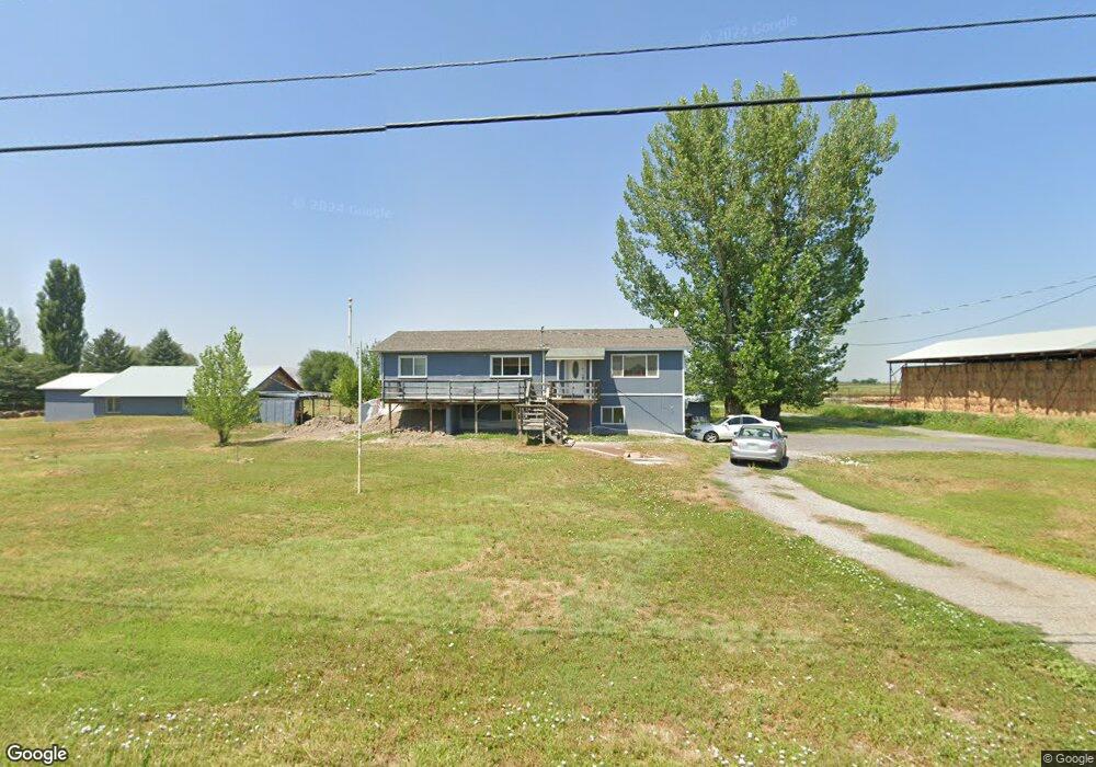
This home is located at 3819 W 600 S, Logan, UT 84321 and is currently estimated at $501,092, approximately $246 per square foot. 3819 W 600 S is a home located in Cache County with nearby schools including Mountainside School, South Cache Middle School, and Mountain Crest High School.
Ownership History
Date
Name
Owned For
Owner Type
Purchase Details
Closed on
May 9, 2025
Sold by
Nicoll Jeremy B and Nicoll Catrina
Bought by
Jeremy And Catrina Nicoll Trust and Nicoll
Current Estimated Value
Purchase Details
Closed on
Apr 17, 2024
Sold by
Easley John F
Bought by
Nicoll Jeremy B and Nicoll Catrina
Home Financials for this Owner
Home Financials are based on the most recent Mortgage that was taken out on this home.
Original Mortgage
$400,000
Interest Rate
6.88%
Mortgage Type
New Conventional
Purchase Details
Closed on
May 30, 2002
Sold by
Easley John F and Easley Sandra D
Bought by
Easley John F and Easley Sandra D
Create a Home Valuation Report for This Property
The Home Valuation Report is an in-depth analysis detailing your home's value as well as a comparison with similar homes in the area
Home Values in the Area
Average Home Value in this Area
Purchase History
| Date | Buyer | Sale Price | Title Company |
|---|---|---|---|
| Jeremy And Catrina Nicoll Trust | -- | None Listed On Document | |
| Nicoll Jeremy B | -- | Northern Title Company | |
| Easley John F | -- | Cache Title Company |
Source: Public Records
Mortgage History
| Date | Status | Borrower | Loan Amount |
|---|---|---|---|
| Previous Owner | Nicoll Jeremy B | $400,000 |
Source: Public Records
Tax History Compared to Growth
Tax History
| Year | Tax Paid | Tax Assessment Tax Assessment Total Assessment is a certain percentage of the fair market value that is determined by local assessors to be the total taxable value of land and additions on the property. | Land | Improvement |
|---|---|---|---|---|
| 2025 | $1,635 | $263,435 | $0 | $0 |
| 2024 | $1,768 | $263,435 | $0 | $0 |
| 2023 | $1,873 | $261,330 | $0 | $0 |
| 2022 | $1,959 | $261,330 | $0 | $0 |
| 2021 | $1,537 | $294,560 | $81,560 | $213,000 |
| 2020 | $1,452 | $261,360 | $81,560 | $179,800 |
| 2019 | $1,204 | $211,869 | $81,560 | $130,309 |
| 2018 | $1,128 | $191,992 | $81,560 | $110,432 |
| 2017 | $1,109 | $104,290 | $0 | $0 |
| 2016 | $1,125 | $96,040 | $0 | $0 |
| 2015 | $1,034 | $96,040 | $0 | $0 |
| 2014 | $828 | $79,285 | $0 | $0 |
| 2013 | -- | $79,285 | $0 | $0 |
Source: Public Records
Map
Nearby Homes
- 3703 W 600 S
- 2400 S 2800 W
- 515 S 1215 W
- 527 S 1215 W
- 518 N 220 E
- 203 E 600 N
- 1200 S 5400 W Unit 13
- 5800 W 1800 S
- 6044 W 1800 S
- 521 S 1215 W
- 509 S 1215 W
- 518 S 1255 W
- 512 S 1255 W
- 848 N 100 E Unit 73
- 1790 W 620 S
- 535 Pheaant Hollow Ln
- 679 Trail Cir
- Redwood Plan at Rivergate - Logan
- Madison Plan at Rivergate - Logan
- Sitka Plan at Sugar Creek - Logan (Townhomes)