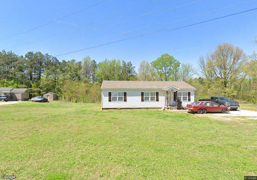
383 Webb Ln Drummonds, TN 38023
Estimated Value: $144,000 - $219,000
Studio
1
Bath
1,104
Sq Ft
$162/Sq Ft
Est. Value
About This Home
This home is located at 383 Webb Ln, Drummonds, TN 38023 and is currently estimated at $178,667, approximately $161 per square foot. 383 Webb Ln is a home located in Tipton County with nearby schools including Drummonds Elementary School, Munford Middle School, and Munford High School.
Ownership History
Date
Name
Owned For
Owner Type
Purchase Details
Closed on
Oct 5, 2020
Sold by
Dacus Henry Frank
Bought by
Dacus Henry Frank and Henry Frank Dacus Revocable Li
Current Estimated Value
Purchase Details
Closed on
Feb 14, 1991
Bought by
Dacus Henry W
Purchase Details
Closed on
Oct 13, 1987
Bought by
Veterans Administration
Purchase Details
Closed on
May 18, 1984
Bought by
Fleming James A and Fleming Shirley
Purchase Details
Closed on
Feb 6, 1984
Purchase Details
Closed on
Feb 1, 1984
Purchase Details
Closed on
Jan 1, 1984
Purchase Details
Closed on
Dec 1, 1983
Purchase Details
Closed on
Jan 1, 1975
Create a Home Valuation Report for This Property
The Home Valuation Report is an in-depth analysis detailing your home's value as well as a comparison with similar homes in the area
Home Values in the Area
Average Home Value in this Area
Purchase History
| Date | Buyer | Sale Price | Title Company |
|---|---|---|---|
| Dacus Henry Frank | -- | None Available | |
| Dacus Henry W | -- | -- | |
| Veterans Administration | -- | -- | |
| Fleming James A | -- | -- | |
| -- | -- | -- | |
| -- | $25,500 | -- | |
| -- | $22,000 | -- | |
| -- | -- | -- | |
| -- | $200 | -- |
Source: Public Records
Tax History
| Year | Tax Paid | Tax Assessment Tax Assessment Total Assessment is a certain percentage of the fair market value that is determined by local assessors to be the total taxable value of land and additions on the property. | Land | Improvement |
|---|---|---|---|---|
| 2025 | $265 | $17,425 | $4,025 | $13,400 |
| 2024 | $265 | $17,425 | $4,025 | $13,400 |
| 2023 | $265 | $17,425 | $4,025 | $13,400 |
| 2022 | $250 | $12,250 | $2,950 | $9,300 |
| 2021 | $250 | $12,250 | $2,950 | $9,300 |
| 2020 | $250 | $12,250 | $2,950 | $9,300 |
| 2019 | $268 | $11,075 | $2,750 | $8,325 |
| 2018 | $268 | $11,075 | $2,750 | $8,325 |
| 2017 | $268 | $11,075 | $2,750 | $8,325 |
| 2016 | $268 | $11,075 | $2,750 | $8,325 |
| 2015 | $268 | $11,075 | $2,750 | $8,325 |
| 2014 | $268 | $11,068 | $0 | $0 |
Source: Public Records
Map
Nearby Homes
- 37 N Wyatt Shankle Cove
- 544 Rachel Shankle Dr
- 1426 Simmons Rd
- 218 Cedar Point Rd
- 121 Reed Cir
- 0 Reed Cir Unit 10192357
- 0 Susan's Cir Unit 10212417
- 138 Gayden Dr
- 447 Abbey Rd Unit D
- 447 Abbey Rd Unit A
- 0 Appleberry Rd
- 0 Simmons Rd Unit 10213607
- 59 Rose Bush St
- 21 Rose Bush St
- 471 Milton Rd
- 33 Rose Bush St
- 53 Rose Bush St
- Beckett Plan at The Villages of Green Meadows
- Bennett Plan at The Villages of Green Meadows
- Cooper Plan at The Villages of Green Meadows
- 359 Webb Ln
- 267 Webb Ln
- 405 Webb Ln
- 935 Armstrong Rd
- 935 Armstrong Rd
- 901 Armstrong Rd
- 1387 Armstrong Rd
- 1345 Armstrong Rd
- 583 Armstrong Rd
- 776 Armstrong Rd
- 828 Armstrong Rd
- 534 Armstrong Rd
- 491 Armstrong Rd
- 465 Armstrong Rd
- 486 Armstrong Rd
- 714 Armstrong Rd
- 410 Armstrong Rd
- 331 Armstrong Rd
- 311 Armstrong Rd
- 365 Armstrong Rd
Your Personal Tour Guide
Ask me questions while you tour the home.