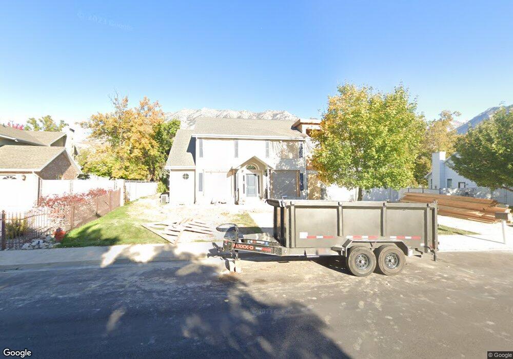
3838 N Cove Dr Provo, UT 84604
Riverside NeighborhoodEstimated Value: $969,000 - $1,196,253
4
Beds
3
Baths
3,044
Sq Ft
$364/Sq Ft
Est. Value
About This Home
This home is located at 3838 N Cove Dr, Provo, UT 84604 and is currently estimated at $1,108,418, approximately $364 per square foot. 3838 N Cove Dr is a home located in Utah County with nearby schools including Canyon Crest Elementary School, Centennial Middle School, and Timpview High School.
Ownership History
Date
Name
Owned For
Owner Type
Purchase Details
Closed on
Dec 10, 2018
Sold by
Mason David D
Bought by
Mason David D and The David D Mason Family Trust
Current Estimated Value
Purchase Details
Closed on
Jul 19, 2018
Sold by
Mason Cynthina A
Bought by
Mason David D
Purchase Details
Closed on
Mar 22, 2004
Sold by
Mason Dean N and Mason Cleo B
Bought by
Mason David D and Mason Cynthia A
Home Financials for this Owner
Home Financials are based on the most recent Mortgage that was taken out on this home.
Original Mortgage
$253,850
Interest Rate
5.64%
Mortgage Type
New Conventional
Purchase Details
Closed on
Jul 29, 2003
Sold by
Mason Dean N and Mason Cleo B
Bought by
Mason Dean N and Mason Cleo B
Create a Home Valuation Report for This Property
The Home Valuation Report is an in-depth analysis detailing your home's value as well as a comparison with similar homes in the area
Home Values in the Area
Average Home Value in this Area
Purchase History
| Date | Buyer | Sale Price | Title Company |
|---|---|---|---|
| Mason David D | -- | None Available | |
| Mason David D | -- | None Available | |
| Mason David D | -- | Signature Title Insurance A | |
| Mason Dean N | -- | Signature Title Insurance A |
Source: Public Records
Mortgage History
| Date | Status | Borrower | Loan Amount |
|---|---|---|---|
| Closed | Mason David D | $253,850 |
Source: Public Records
Tax History
| Year | Tax Paid | Tax Assessment Tax Assessment Total Assessment is a certain percentage of the fair market value that is determined by local assessors to be the total taxable value of land and additions on the property. | Land | Improvement |
|---|---|---|---|---|
| 2025 | $5,239 | $590,260 | -- | -- |
| 2024 | $5,239 | $515,735 | $0 | $0 |
| 2023 | $5,087 | $493,625 | $0 | $0 |
| 2022 | $5,352 | $523,655 | $0 | $0 |
| 2021 | $4,446 | $758,800 | $330,100 | $428,700 |
| 2020 | $4,347 | $695,400 | $275,100 | $420,300 |
| 2019 | $4,781 | $795,400 | $275,100 | $520,300 |
| 2018 | $4,121 | $695,400 | $235,800 | $459,600 |
| 2017 | $3,866 | $358,435 | $0 | $0 |
| 2016 | $3,382 | $292,270 | $0 | $0 |
| 2015 | $2,976 | $259,985 | $0 | $0 |
| 2014 | $2,567 | $233,750 | $0 | $0 |
Source: Public Records
Map
Nearby Homes
- 404 W 3700 N
- 3535 N 160 St W
- 455 W 4150 St N
- 3857 N 100 E
- 126 Woodside Dr
- 3339 N Cottonwood Ln
- 4246 N Stonecrossing
- 3588 N 230 E
- 299 E 4000 N
- 3305 N Shadowbrook Cir
- 111 Candlewood Place
- 407 E 3900 Rd N Unit 1
- 407 E 3900 Rd N
- 3711 N Canyon Rd
- 3690 N Canyon Rd
- 478 S 950 E
- 756 S 900 E
- 489 S 900 E
- 5600 N Canyon Rd
- 325 S 1000 E