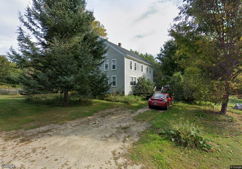
384 2nd Crown Point Rd Strafford, NH 03884
Estimated Value: $441,135 - $558,000
3
Beds
2
Baths
1,872
Sq Ft
$270/Sq Ft
Est. Value
About This Home
This home is located at 384 2nd Crown Point Rd, Strafford, NH 03884 and is currently estimated at $504,534, approximately $269 per square foot. 384 2nd Crown Point Rd is a home located in Strafford County with nearby schools including Strafford School and Coe-Brown Northwood Academy.
Ownership History
Date
Name
Owned For
Owner Type
Purchase Details
Closed on
May 22, 2012
Sold by
Lapanne Rene J and Lapanne Catherine
Bought by
Schultz Susan C
Current Estimated Value
Purchase Details
Closed on
Mar 9, 2011
Sold by
Hilliard Theresa
Bought by
Lapanne Rene J
Create a Home Valuation Report for This Property
The Home Valuation Report is an in-depth analysis detailing your home's value as well as a comparison with similar homes in the area
Home Values in the Area
Average Home Value in this Area
Purchase History
| Date | Buyer | Sale Price | Title Company |
|---|---|---|---|
| Schultz Susan C | $193,000 | -- | |
| Schultz Susan C | $193,000 | -- | |
| Lapanne Rene J | -- | -- | |
| Lapanne Rene J | -- | -- |
Source: Public Records
Mortgage History
| Date | Status | Borrower | Loan Amount |
|---|---|---|---|
| Open | Lapanne Rene J | $187,499 | |
| Closed | Lapanne Rene J | $0 |
Source: Public Records
Tax History
| Year | Tax Paid | Tax Assessment Tax Assessment Total Assessment is a certain percentage of the fair market value that is determined by local assessors to be the total taxable value of land and additions on the property. | Land | Improvement |
|---|---|---|---|---|
| 2024 | $5,535 | $280,100 | $70,300 | $209,800 |
| 2023 | $5,221 | $280,100 | $70,300 | $209,800 |
| 2022 | $4,798 | $280,100 | $70,300 | $209,800 |
| 2021 | $4,990 | $270,300 | $70,300 | $200,000 |
| 2020 | $4,843 | $188,800 | $64,400 | $124,400 |
| 2019 | $4,431 | $188,800 | $64,400 | $124,400 |
| 2018 | $5,748 | $183,300 | $64,400 | $118,900 |
| 2016 | $3,840 | $180,700 | $64,400 | $116,300 |
| 2015 | $3,586 | $164,400 | $78,300 | $86,100 |
| 2014 | $3,808 | $164,400 | $78,300 | $86,100 |
| 2013 | $3,729 | $164,400 | $78,300 | $86,100 |
| 2012 | $3,811 | $170,300 | $78,300 | $92,000 |
Source: Public Records
Map
Nearby Homes
- 20 Lorraines Ln
- 948 Strafford Rd
- 464 Long Shores Dr
- 739 Berry River Rd
- 0 Sloper Rd Unit 6
- 38 Strafford Rd
- 825 Second Crown Point Rd
- 207-002 Washington St
- 1416 Parker Mountain Rd
- 179 Four Rod Rd
- 8 Juniper Ln
- 395 Greenhill Rd
- 0 Estes Rd Unit 74-A
- 59 Estes Rd
- 81 Hansonville Rd
- 400 Scruton Pond Rd
- 12 Isabelle Ln
- 00 Squire Rd
- 28-1 Range Rd
- 12 Cornwall Place
- 170 2nd Crown Point Rd
- 368 Second Crown Point Rd
- 397 Second Crown Point Rd
- 400 2nd Crown Point Rd
- 397 2nd Crown Point Rd
- 934 Strafford Rd
- 659 Strafford Rd
- 945 Strafford Rd
- 616 Strafford Rd
- Lot 30-7 Second Crown Point Rd Unit 30-7
- 352 2nd Crown Point Rd
- 694 Strafford Rd
- 696 Strafford Rd
- 658 Strafford Rd
- 13 Jennifer Ln
- 5 Jennifer Ln
- 435 2nd Crown Point Rd
- 17 Jennifer Ln
- 25 Jennifer Ln
- 8 Jennifer Ln