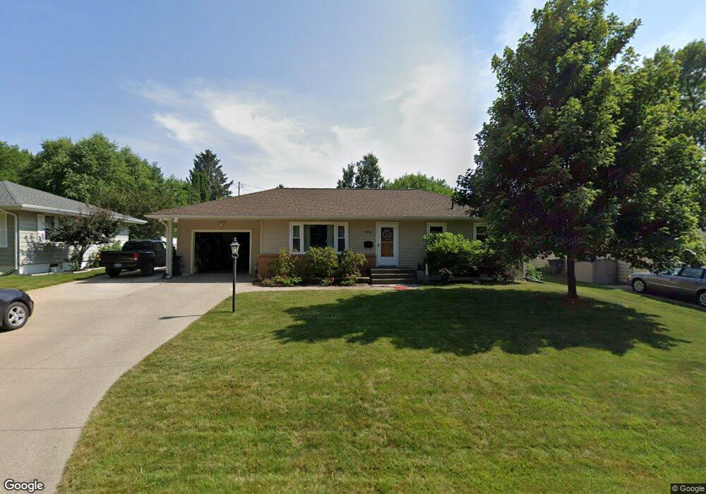
3841 Clark Rd SE Cedar Rapids, IA 52403
Estimated Value: $155,000 - $243,000
2
Beds
2
Baths
1,223
Sq Ft
$176/Sq Ft
Est. Value
About This Home
This home is located at 3841 Clark Rd SE, Cedar Rapids, IA 52403 and is currently estimated at $215,112, approximately $175 per square foot. 3841 Clark Rd SE is a home located in Linn County with nearby schools including Erskine Elementary School, McKinley STEAM Academy, and George Washington High School.
Ownership History
Date
Name
Owned For
Owner Type
Purchase Details
Closed on
Aug 3, 1998
Sold by
Carlson V R and Carlson Jo G
Bought by
Dilts Dale and Gorsh Debbie A
Current Estimated Value
Home Financials for this Owner
Home Financials are based on the most recent Mortgage that was taken out on this home.
Original Mortgage
$92,150
Outstanding Balance
$19,442
Interest Rate
7.05%
Estimated Equity
$195,670
Create a Home Valuation Report for This Property
The Home Valuation Report is an in-depth analysis detailing your home's value as well as a comparison with similar homes in the area
Purchase History
We collect this data history from publicly available records. To have your information removed, we recommend requesting removal directly through your county’s website.
| Date | Buyer | Sale Price | Title Company |
|---|---|---|---|
| Dilts Dale | $94,500 | -- |
Source: Public Records
Mortgage History
We collect this data history from publicly available records. To have your information removed, we recommend requesting removal directly through your county’s website.
| Date | Status | Borrower | Loan Amount |
|---|---|---|---|
| Open | Dilts Dale | $92,150 |
Source: Public Records
Tax History
| Year | Tax Paid | Tax Assessment Tax Assessment Total Assessment is a certain percentage of the fair market value that is determined by local assessors to be the total taxable value of land and additions on the property. | Land | Improvement |
|---|---|---|---|---|
| 2025 | $3,736 | $235,000 | $42,400 | $192,600 |
| 2024 | $3,896 | $232,100 | $42,400 | $189,700 |
| 2023 | $3,896 | $221,600 | $42,400 | $179,200 |
| 2022 | $3,392 | $193,600 | $33,200 | $160,400 |
| 2021 | $3,638 | $172,700 | $33,200 | $139,500 |
| 2020 | $3,638 | $173,500 | $29,500 | $144,000 |
| 2019 | $3,250 | $159,300 | $29,500 | $129,800 |
| 2018 | $3,156 | $159,300 | $29,500 | $129,800 |
| 2017 | $3,203 | $153,500 | $29,500 | $124,000 |
| 2016 | $3,203 | $150,700 | $29,500 | $121,200 |
| 2015 | $2,979 | $139,965 | $29,488 | $110,477 |
| 2014 | $2,794 | $135,416 | $29,488 | $105,928 |
| 2013 | $2,634 | $135,416 | $29,488 | $105,928 |
Source: Public Records
Map
Nearby Homes
- 2214 Kestrel Dr SE
- 2403 Kestrel Dr SE
- 2226 Kestrel Dr SE
- 3112 Peregrine Ct SE
- 2306 Kestrel Dr SE
- 2420 Kestrel Dr SE
- 2409 Kestrel Dr SE
- 2421 Kestrel Dr SE
- 2416 Kestrel Dr SE
- 2221 Kestrel Dr SE
- 2319 Kestrel Dr SE
- 2415 Kestrel Dr SE
- 2325 Kestrel Dr SE
- 2313 Kestrel Dr SE
- 3106 Peregrine Ct SE
- 2307 Kestrel Dr SE
- 2312 Kestrel Dr SE
- 2427 Kestrel Dr SE
- 3103 Peregrine Ct SE
- 3100 Peregrine Ct SE
- 3837 Clark Rd SE
- 3836 Clark Rd SE
- 3832 Clark Rd SE
- 3840 Clark Rd SE
- 3829 Clark Rd SE
- 3845 Clark Rd SE
- 3828 Clark Rd SE
- 3844 Clark Rd SE
- 3838 Soutter Avenue Ct SE
- 3832 Soutter Avenue Ct SE
- 3844 Soutter Avenue Ct SE
- 3837 Skylark Ln SE
- 3825 Clark Rd SE
- Lot 6 Kestrel Estates 1st Addition
- Lot 5 Kestrel Estates 1st Addition
- Lot 4 Kestrel Estates 1st Addition
- Lot 1 Kestrel Heights 2nd Addition
- Lot 1-6 Kestrel Estates 1st Addition
- Lot 1-5 Kestrel Estates 1st Addition
- Lot 1-4 Kestrel Estates 1st Addition
Your Personal Tour Guide
Ask me questions while you tour the home.