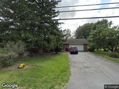
3844 Orrstown Rd Orrstown, PA 17244
Estimated Value: $243,611 - $296,000
--
Bed
1
Bath
1,504
Sq Ft
$172/Sq Ft
Est. Value
About This Home
This home is located at 3844 Orrstown Rd, Orrstown, PA 17244 and is currently estimated at $259,403, approximately $172 per square foot. 3844 Orrstown Rd is a home located in Franklin County with nearby schools including Shippensburg Area Senior High School, Stoney Creek School, and Clearfield Parochial School.
Ownership History
Date
Name
Owned For
Owner Type
Purchase Details
Closed on
May 3, 2024
Sold by
Witmer Lynn A and Witmer Mary Beth
Bought by
Witmer Jerald Michael and Witmer Larissa Kim
Current Estimated Value
Home Financials for this Owner
Home Financials are based on the most recent Mortgage that was taken out on this home.
Original Mortgage
$215,000
Outstanding Balance
$212,201
Interest Rate
6.87%
Mortgage Type
New Conventional
Estimated Equity
$43,779
Create a Home Valuation Report for This Property
The Home Valuation Report is an in-depth analysis detailing your home's value as well as a comparison with similar homes in the area
Home Values in the Area
Average Home Value in this Area
Purchase History
| Date | Buyer | Sale Price | Title Company |
|---|---|---|---|
| Witmer Jerald Michael | $245,000 | None Listed On Document |
Source: Public Records
Mortgage History
| Date | Status | Borrower | Loan Amount |
|---|---|---|---|
| Open | Witmer Jerald Michael | $215,000 | |
| Previous Owner | Witmer Lynn A | $50,000 |
Source: Public Records
Tax History Compared to Growth
Tax History
| Year | Tax Paid | Tax Assessment Tax Assessment Total Assessment is a certain percentage of the fair market value that is determined by local assessors to be the total taxable value of land and additions on the property. | Land | Improvement |
|---|---|---|---|---|
| 2025 | $3,301 | $22,300 | $2,350 | $19,950 |
| 2024 | $2,889 | $22,300 | $2,350 | $19,950 |
| 2023 | $2,830 | $22,300 | $2,350 | $19,950 |
| 2022 | $2,811 | $22,300 | $2,350 | $19,950 |
| 2021 | $2,728 | $22,300 | $2,350 | $19,950 |
| 2020 | $2,866 | $22,300 | $2,350 | $19,950 |
| 2019 | $2,839 | $22,300 | $2,350 | $19,950 |
| 2018 | $2,892 | $22,300 | $2,350 | $19,950 |
| 2017 | $2,915 | $22,300 | $2,350 | $19,950 |
| 2016 | $624 | $22,300 | $2,350 | $19,950 |
| 2015 | $581 | $22,300 | $2,350 | $19,950 |
| 2014 | $581 | $22,300 | $2,350 | $19,950 |
Source: Public Records
Map
Nearby Homes
- 3979 Campbell Cir
- 4560 Orrstown Rd Unit 1
- 6108 Orrstown Rd
- 2000 Orrstown Rd
- 251 Grove Dr
- 30 Jamestown Rd
- 0 Edison Dr
- 1565 Orrstown Rd
- 105 Central Way
- 201 Grove Dr
- 0 Central Way
- 10700 Thornwood Rd
- 10464 Mapleton Rd
- 1078 Celeste Dr
- 1136 Ashton Dr
- 47 Diffys Dr
- 8074 Molly Pitcher Hwy
- 43 Maizefield Dr
- 54 Lenwood Park Unit 54
- 4057 MacLays Mill Rd
- 3844 Orrstown Rd
- 3830 Orrstown Rd
- 3856 Orrstown Rd
- 3855 Orrstown Rd
- 3855 Orrstown Rd
- 3871 Orrstown Rd
- 3843 Orrstown Rd
- 3827 Orrstown Rd
- 4002 Orrstown Rd
- 4002 Orrstown Rd
- 3773 Orrstown Rd
- 3930 Orrstown Rd
- 3929 Orrstown Rd
- 3897 Orrstown Rd
- 3766 Orrstown Rd
- 3923 Campbell Cir
- 3765 Orrstown Rd
- 3947 Orrstown Rd
- 3815 Orrstown Rd
- 3931 Campbell Cir