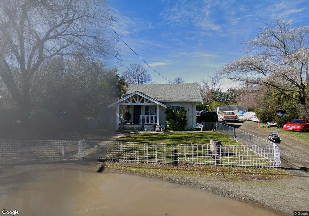
385 S Forbes St Lakeport, CA 95453
Estimated Value: $215,000 - $278,000
2
Beds
1
Bath
1,020
Sq Ft
$237/Sq Ft
Est. Value
About This Home
This home is located at 385 S Forbes St, Lakeport, CA 95453 and is currently estimated at $242,190, approximately $237 per square foot. 385 S Forbes St is a home located in Lake County with nearby schools including Lakeport Elementary School, Terrace Middle School, and Clear Lake High School.
Ownership History
Date
Name
Owned For
Owner Type
Purchase Details
Closed on
Jul 21, 2009
Sold by
Stark Robert Timothy and Stark Terrie
Bought by
Yee Joanna Kue Chong and Chen Peter Hao Ying
Current Estimated Value
Purchase Details
Closed on
Oct 15, 2008
Sold by
Thompson James A
Bought by
Stark Robert Timothy
Home Financials for this Owner
Home Financials are based on the most recent Mortgage that was taken out on this home.
Original Mortgage
$90,000
Interest Rate
5.88%
Mortgage Type
Purchase Money Mortgage
Purchase Details
Closed on
Dec 5, 2006
Sold by
Stark Robert L
Bought by
Thompson James T
Create a Home Valuation Report for This Property
The Home Valuation Report is an in-depth analysis detailing your home's value as well as a comparison with similar homes in the area
Home Values in the Area
Average Home Value in this Area
Purchase History
| Date | Buyer | Sale Price | Title Company |
|---|---|---|---|
| Yee Joanna Kue Chong | $97,500 | Fidelity Natl Title Co Of Ca | |
| Stark Robert Timothy | $405,500 | First American Title Company | |
| Thompson James T | -- | None Available |
Source: Public Records
Mortgage History
| Date | Status | Borrower | Loan Amount |
|---|---|---|---|
| Previous Owner | Stark Robert Timothy | $90,000 |
Source: Public Records
Tax History
| Year | Tax Paid | Tax Assessment Tax Assessment Total Assessment is a certain percentage of the fair market value that is determined by local assessors to be the total taxable value of land and additions on the property. | Land | Improvement |
|---|---|---|---|---|
| 2025 | $1,618 | $124,254 | $95,286 | $28,968 |
| 2024 | $1,578 | $121,818 | $93,418 | $28,400 |
| 2023 | $1,547 | $119,431 | $91,587 | $27,844 |
| 2022 | $1,518 | $117,091 | $89,792 | $27,299 |
| 2021 | $1,504 | $114,796 | $88,032 | $26,764 |
| 2020 | $1,459 | $113,620 | $87,130 | $26,490 |
| 2019 | $1,453 | $111,393 | $85,422 | $25,971 |
| 2018 | $1,290 | $109,210 | $83,748 | $25,462 |
| 2017 | $1,282 | $107,069 | $82,106 | $24,963 |
| 2016 | $1,239 | $104,971 | $80,497 | $24,474 |
| 2015 | $1,224 | $103,395 | $79,288 | $24,107 |
| 2014 | $1,136 | $101,370 | $77,735 | $23,635 |
Source: Public Records
Map
Nearby Homes
- 201 S Main St
- 320 Armstrong St
- 225 N Tunis St
- 250 3rd St
- 1025 Martin St Unit 3
- 1025 Martin St Unit 54
- 1025 Martin St Unit 42
- 1025 Martin St Unit 41
- 1025 Martin St Unit 2
- 360 3rd St
- 302 N Main St
- 305 N Brush St
- 220 4th St
- 455 N Forbes St
- 10 Royale Ave Unit 2
- 10 Royale Ave Unit 23B
- 10 Royale Ave Unit 13A-2
- 110 S Russell St
- 1025 Armstrong St
- 65 Royale Ave