
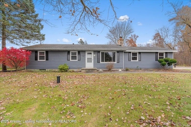
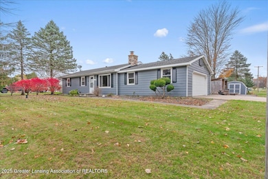
3863 Delano Dr Eaton Rapids, MI 48827
Estimated payment $1,291/month
Highlights
- River Access
- Waterfront
- Ranch Style House
- River View
- Wood Burning Stove
- Corner Lot
About This Home
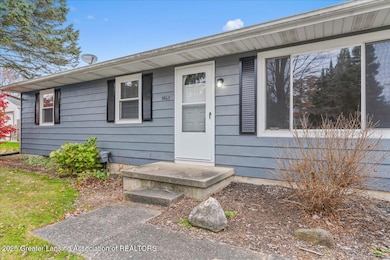
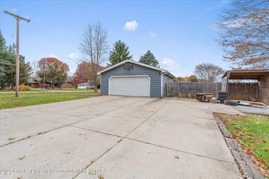
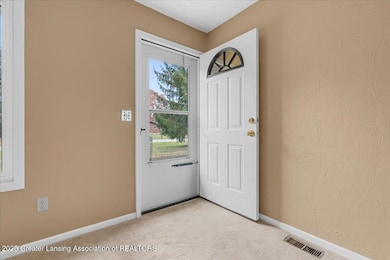
Welcome to this charming 3 bedroom, 1 bath ranch nestled on a spacious corner lot along a quiet drive that ends in a dead end. Enjoy peaceful country living with a beautiful scenic river just across the road. This home offers an attached 2-car garage, a large fenced backyard, and a full basement that provides plenty of storage space or potential to finish for additional living area. The dining room features sliding glass doors that open to the backyard - perfect for relaxing or entertaining. A wonderful setting for anyone who values privacy, nature and tranquility. Year built is unknown
Home Details
Home Type
- Single Family
Est. Annual Taxes
- $1,869
Year Built
- Built in 1978
Lot Details
- 0.34 Acre Lot
- Lot Dimensions are 100x150
- Waterfront
- Privacy Fence
- Wood Fence
- Landscaped
- Corner Lot
- Back Yard Fenced and Front Yard
- Property is zoned Rural Residential
Parking
- 2 Car Attached Garage
- Parking Storage or Cabinetry
- Garage Door Opener
- Driveway
Property Views
- River
- Woods
- Neighborhood
Home Design
- Ranch Style House
- Shingle Roof
- Vinyl Siding
Interior Spaces
- 1,008 Sq Ft Home
- Wood Burning Stove
- Shutters
- Fire and Smoke Detector
- Washer and Electric Dryer Hookup
Kitchen
- Eat-In Kitchen
- Oven
- Electric Range
Flooring
- Carpet
- Laminate
Bedrooms and Bathrooms
- 3 Bedrooms
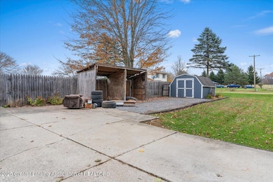
Partially Finished Basement
- Basement Fills Entire Space Under The House
- Sump Pump
- Fireplace in Basement
Outdoor Features
- River Access
- Patio
- Shed
- Front Porch
Utilities
- Forced Air Heating and Cooling System
- Heating System Uses Wood
- 100 Amp Service
- Well
- Water Heater
- Water Softener is Owned
- Septic Tank
- High Speed Internet
- Cable TV Available
Community Details
- No Home Owners Association
Map
Home Values in the Area
Average Home Value in this Area
Tax History
| Year | Tax Paid | Tax Assessment Tax Assessment Total Assessment is a certain percentage of the fair market value that is determined by local assessors to be the total taxable value of land and additions on the property. | Land | Improvement |
|---|---|---|---|---|
| 2025 | $1,869 | $87,400 | $12,000 | $75,400 |
| 2024 | $1,683 | $88,400 | $12,000 | $76,400 |
| 2023 | $1,683 | $78,100 | $12,000 | $66,100 |
| 2022 | $1,555 | $63,000 | $7,700 | $55,300 |
| 2021 | $1,535 | $58,300 | $0 | $0 |
| 2020 | $1,514 | $56,100 | $0 | $0 |
| 2019 | $1,466 | $54,800 | $7,700 | $47,100 |
| 2018 | $1,432 | $55,600 | $7,700 | $47,900 |
| 2017 | $1,344 | $55,600 | $7,700 | $47,900 |
| 2016 | -- | $45,500 | $5,500 | $40,000 |
| 2015 | -- | $45,200 | $7,693 | $37,507 |
| 2014 | -- | $41,600 | $7,816 | $33,784 |
Property History
| Date | Event | Price | List to Sale | Price per Sq Ft |
|---|---|---|---|---|
| 11/05/2025 11/05/25 | For Sale | $215,000 | 0.0% | $213 / Sq Ft |
| 11/04/2025 11/04/25 | Off Market | $215,000 | -- | -- |
Purchase History
| Date | Type | Sale Price | Title Company |
|---|---|---|---|
| Warranty Deed | $99,900 | -- |
Mortgage History
| Date | Status | Loan Amount | Loan Type |
|---|---|---|---|
| Open | $91,932 | FHA |
Source: Greater Lansing Association of Realtors®
MLS Number: 292434
APN: 13-13-17-429-010
Disclaimer: Certain information contained herein is derived from information provided by parties other than Homes.com. All information provided is deemed reliable, but is not guaranteed to be accurate and should be independently verified.
![]() IDX information is provided exclusively for Consumers'
IDX information is provided exclusively for Consumers'
personal, non-commercial use, that it may not be used for any purpose other than to identify prospective properties Consumers may be interested in purchasing. Data is deemed reliable but is not guaranteed accurate by the MLS.
Copyright © 2025 Greater Lansing Association of REALTORS®
- 6280 Kinneville Rd
- 0 Ferris Unit 290887
- 3020 Aurelius Rd
- 6607 O'Mara Dr
- Vl Gale Rd
- 2391 S Onondaga Rd
- Vl Tucker Rd Lot Unit WP001
- S Gale Rd
- 7291 Tucker Rd
- 0 Edgar Rd Unit 290334
- VL Tucker Rd Lot#wp001
- 6042 W Plains Rd
- 10307 Holmes Hwy
- 5340 Old Plank Rd
- 12247 Onondaga Rd
- 5710 Houston Rd
- 9912 Kinneville Rd
- 4662 W Barnes Rd
- Parcel 4 Oakridge Dr
- Parcel 1 Oakridge Dr
- 755 Island Ct
- 754 State St
- 223 N Main St
- 300 Bay Port Cir Unit 55
- 277 Copper Harbor Unit 40
- 940 S Cedar St
- 703 E Cherry St
- 895 N Cedar Rd
- 805 Mason Hills Dr
- 1594 Aurelius Rd
- 4106 Red Willow Dr
- 4181 Hancock Dr
- 4233 Holt Rd Unit 2
- 4233 Holt Rd Unit 2
- 2030 Cedar St
- 2085 Cedar St
- 2141 Aurelius Rd
- 4254 Bond St
- 2294 Main St
- 3879 Lone Pine Dr
