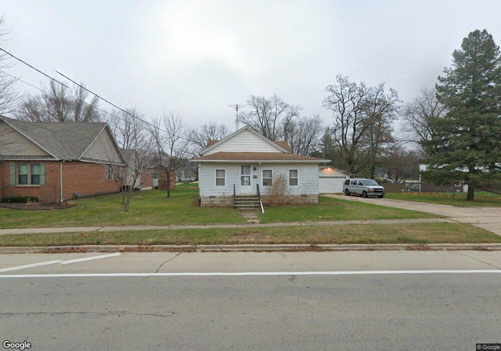
388 E Main St Braidwood, IL 60408
Estimated Value: $214,909 - $262,000
Studio
--
Bath
--
Sq Ft
0.45
Acres
About This Home
This home is located at 388 E Main St, Braidwood, IL 60408 and is currently estimated at $239,227. 388 E Main St is a home located in Will County with nearby schools including Reed-Custer Intermediate School, Reed-Custer Middle School, and Reed-Custer High School.
Ownership History
Date
Name
Owned For
Owner Type
Purchase Details
Closed on
Jul 16, 2019
Sold by
Flynn James E
Bought by
Flynn James E and James E Flynn Living Trust
Current Estimated Value
Purchase Details
Closed on
Sep 17, 1998
Sold by
Giovannoni William and Giovannoni John G
Bought by
Flynn James E and Flynn Jean A
Home Financials for this Owner
Home Financials are based on the most recent Mortgage that was taken out on this home.
Original Mortgage
$68,800
Interest Rate
6.99%
Create a Home Valuation Report for This Property
The Home Valuation Report is an in-depth analysis detailing your home's value as well as a comparison with similar homes in the area
Home Values in the Area
Average Home Value in this Area
Purchase History
| Date | Buyer | Sale Price | Title Company |
|---|---|---|---|
| Flynn James E | -- | Attorney | |
| Flynn James E | $87,000 | -- | |
| Flynn James E | -- | -- |
Source: Public Records
Mortgage History
| Date | Status | Borrower | Loan Amount |
|---|---|---|---|
| Closed | Flynn James E | $68,800 |
Source: Public Records
Tax History Compared to Growth
Tax History
| Year | Tax Paid | Tax Assessment Tax Assessment Total Assessment is a certain percentage of the fair market value that is determined by local assessors to be the total taxable value of land and additions on the property. | Land | Improvement |
|---|---|---|---|---|
| 2024 | $1,897 | $67,793 | $12,168 | $55,625 |
| 2023 | $1,897 | $60,719 | $10,898 | $49,821 |
| 2022 | $2,294 | $55,099 | $9,889 | $45,210 |
| 2021 | $2,334 | $52,591 | $9,439 | $43,152 |
| 2020 | $2,738 | $49,826 | $8,943 | $40,883 |
| 2019 | $2,552 | $47,050 | $8,445 | $38,605 |
| 2018 | $2,367 | $45,024 | $8,081 | $36,943 |
| 2017 | $2,373 | $44,142 | $7,923 | $36,219 |
| 2016 | $2,293 | $42,690 | $7,662 | $35,028 |
| 2015 | $2,242 | $41,588 | $7,464 | $34,124 |
| 2014 | $2,242 | $41,588 | $7,464 | $34,124 |
| 2013 | $2,242 | $44,479 | $7,983 | $36,496 |
Source: Public Records
Map
Nearby Homes
- 302 Oak St
- 158 S Railroad St
- 258 S Center St
- 000 N Center St
- 124 S Lincoln St
- 560 N Washington St
- 443 W Main St
- 000 W Cermak Rd
- 106 Harbor Landing
- 470 N School St
- 46 Lakeshore Dr
- 386 W 3rd St
- 303 N Division St
- 599 N School St
- 430 N Division St
- 495 N Division St
- 0000 N Division St
- 660 W 1st St
- 605 N Division St
- 13 Hole in The Wall Rd