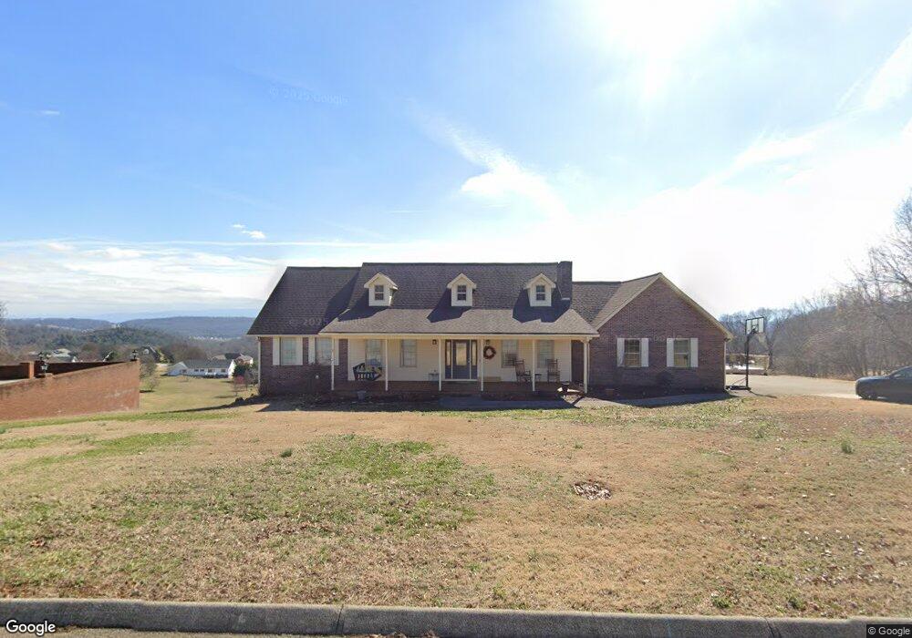
388 Independence Dr Jefferson City, TN 37760
Estimated Value: $469,632 - $666,000
--
Bed
3
Baths
1,944
Sq Ft
$291/Sq Ft
Est. Value
About This Home
This home is located at 388 Independence Dr, Jefferson City, TN 37760 and is currently estimated at $565,408, approximately $290 per square foot. 388 Independence Dr is a home located in Jefferson County.
Ownership History
Date
Name
Owned For
Owner Type
Purchase Details
Closed on
Dec 22, 2016
Sold by
Franklin Gary W
Bought by
Franklin Gary W
Current Estimated Value
Purchase Details
Closed on
Dec 16, 2010
Sold by
Franklin Angela M
Bought by
Franklin Gary W
Home Financials for this Owner
Home Financials are based on the most recent Mortgage that was taken out on this home.
Original Mortgage
$76,000
Interest Rate
4.42%
Purchase Details
Closed on
Sep 30, 1996
Bought by
Franklin Gary W and Franklin Angela M
Purchase Details
Closed on
Jan 18, 1996
Bought by
Franklin Gary W and Teresa A Angela M
Create a Home Valuation Report for This Property
The Home Valuation Report is an in-depth analysis detailing your home's value as well as a comparison with similar homes in the area
Home Values in the Area
Average Home Value in this Area
Purchase History
| Date | Buyer | Sale Price | Title Company |
|---|---|---|---|
| Franklin Gary W | -- | -- | |
| Franklin Gary W | -- | -- | |
| Franklin Gary W | $17,500 | -- | |
| Franklin Gary W | $35,000 | -- |
Source: Public Records
Mortgage History
| Date | Status | Borrower | Loan Amount |
|---|---|---|---|
| Previous Owner | Franklin Gary W | $76,000 |
Source: Public Records
Tax History Compared to Growth
Tax History
| Year | Tax Paid | Tax Assessment Tax Assessment Total Assessment is a certain percentage of the fair market value that is determined by local assessors to be the total taxable value of land and additions on the property. | Land | Improvement |
|---|---|---|---|---|
| 2025 | $1,719 | $120,175 | $19,000 | $101,175 |
| 2023 | $1,604 | $69,750 | $0 | $0 |
| 2022 | $1,528 | $69,750 | $15,750 | $54,000 |
| 2021 | $1,528 | $69,750 | $15,750 | $54,000 |
| 2020 | $1,528 | $69,750 | $15,750 | $54,000 |
| 2019 | $1,528 | $69,750 | $15,750 | $54,000 |
| 2018 | $1,499 | $63,775 | $12,500 | $51,275 |
| 2017 | $1,499 | $63,775 | $12,500 | $51,275 |
| 2016 | $1,499 | $63,775 | $12,500 | $51,275 |
| 2015 | $1,499 | $63,775 | $12,500 | $51,275 |
| 2014 | $1,499 | $63,775 | $12,500 | $51,275 |
Source: Public Records
Map
Nearby Homes
- 565 Providence Dr
- 784 Constitution Dr
- 405 Colonial St
- 434 Mcguire Rd
- 428 Mcguire Rd
- 203 Bicentennial Dr
- 422 Mcguire Rd
- 419 Colonial St
- 409 Sunrise Ridge Dr
- 1052 Patriots Landing
- 1036 Patriots Landing
- 1032 Patriot Landing Dr
- Tract 1 Patriot Landing Dr
- 6240 Sycamore Stream Rd
- 6232 Sycamore Stream Rd
- 6215 Sycamore Stream Rd
- 6207 Sycamore Stream Rd
- 3063 Villa Creekside Dr
- 3067 Villa Creekside Dr
- 925 Mcguire Rd
- 392 Independence Dr
- 389 Independence Dr
- 380 Independence Dr
- 587 Providence Dr
- 394 Independence Dr
- Lot 1 Independence Dr
- Lot 3 Independence Dr
- LOT 73 -Independence Dr Unit S/D PATRIOT HILLS GO
- LOT 73 -Independence Dr
- 393 Independence Dr
- 379 Independence Dr
- 376 Independence Dr
- 600 Providence Dr
- Lot 73- Independence Dr
- 405 Independence Dr
- LOT 2- Independence Dr
- LOT 1- Independence Dr
- LOT 3 - Independence Dr
- 0 Independence Dr
- 375 Independence Dr