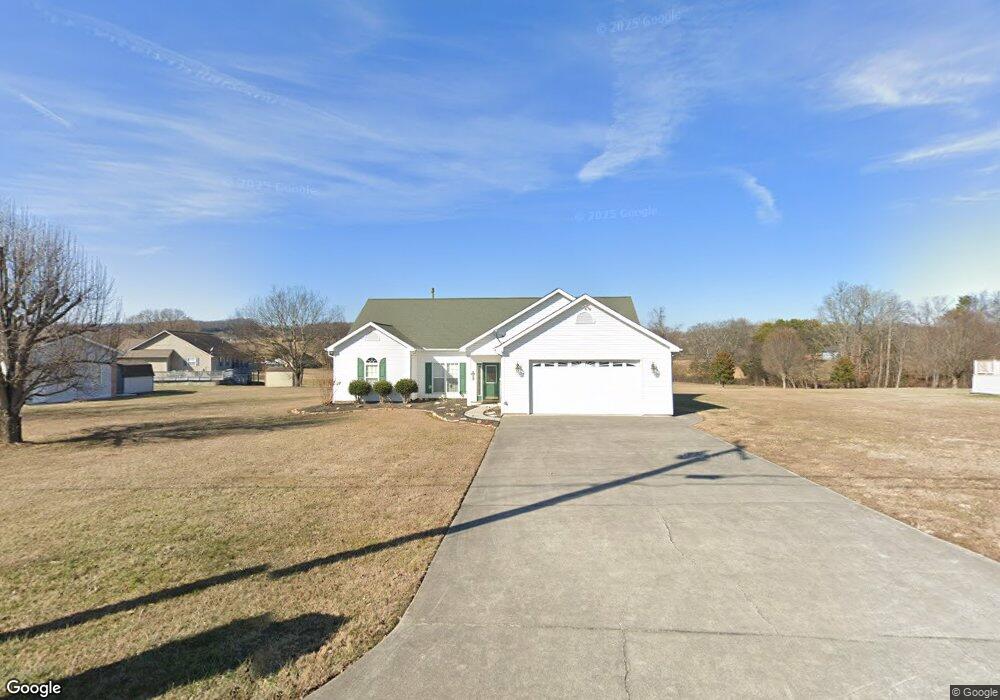
388 Terry Point Rd Dandridge, TN 37725
Estimated Value: $382,000 - $486,000
Studio
3
Baths
1,854
Sq Ft
$233/Sq Ft
Est. Value
About This Home
This home is located at 388 Terry Point Rd, Dandridge, TN 37725 and is currently estimated at $431,297, approximately $232 per square foot. 388 Terry Point Rd is a home located in Jefferson County.
Ownership History
Date
Name
Owned For
Owner Type
Purchase Details
Closed on
Feb 8, 2012
Sold by
Weiss Lawrence B
Bought by
Bush Sandra and Williams Stacie Bush
Current Estimated Value
Purchase Details
Closed on
Oct 8, 2003
Sold by
Weiss Lawrence B and Weiss Sande R
Bought by
Weiss Hyman N
Purchase Details
Closed on
May 28, 2003
Sold by
Lowe Jason R and Lowe Summer P
Bought by
Weiss Lawrence B and Weiss Sande R
Purchase Details
Closed on
Oct 29, 2001
Sold by
Tommy Lowe
Bought by
Jason Lowe
Home Financials for this Owner
Home Financials are based on the most recent Mortgage that was taken out on this home.
Original Mortgage
$91,266
Interest Rate
6.67%
Purchase Details
Closed on
Oct 26, 2001
Bought by
Lowe Jason R and Lowe Summer P
Home Financials for this Owner
Home Financials are based on the most recent Mortgage that was taken out on this home.
Original Mortgage
$91,266
Interest Rate
6.67%
Purchase Details
Closed on
Jul 13, 2000
Sold by
Tommy Lowe
Bought by
Tommy Lowe
Create a Home Valuation Report for This Property
The Home Valuation Report is an in-depth analysis detailing your home's value as well as a comparison with similar homes in the area
Home Values in the Area
Average Home Value in this Area
Purchase History
| Date | Buyer | Sale Price | Title Company |
|---|---|---|---|
| Bush Sandra | $155,000 | -- | |
| Weiss Hyman N | $140,000 | -- | |
| Weiss Lawrence B | $140,000 | -- | |
| Jason Lowe | $88,604 | -- | |
| Lowe Jason R | $88,600 | -- | |
| Tommy Lowe | $23,000 | -- |
Source: Public Records
Mortgage History
| Date | Status | Borrower | Loan Amount |
|---|---|---|---|
| Previous Owner | Tommy Lowe | $91,266 | |
| Previous Owner | Tommy Lowe | $91,266 |
Source: Public Records
Tax History
| Year | Tax Paid | Tax Assessment Tax Assessment Total Assessment is a certain percentage of the fair market value that is determined by local assessors to be the total taxable value of land and additions on the property. | Land | Improvement |
|---|---|---|---|---|
| 2025 | $1,287 | $90,000 | $15,000 | $75,000 |
| 2023 | $1,060 | $46,075 | $0 | $0 |
| 2022 | $1,009 | $46,075 | $8,000 | $38,075 |
| 2021 | $1,009 | $46,075 | $8,000 | $38,075 |
| 2020 | $1,009 | $46,075 | $8,000 | $38,075 |
| 2019 | $1,009 | $46,075 | $8,000 | $38,075 |
| 2018 | $919 | $39,125 | $6,000 | $33,125 |
| 2017 | $919 | $39,125 | $6,000 | $33,125 |
| 2016 | $919 | $39,125 | $6,000 | $33,125 |
| 2015 | $919 | $39,125 | $6,000 | $33,125 |
| 2014 | $919 | $39,125 | $6,000 | $33,125 |
Source: Public Records
Map
Nearby Homes
- 1710 Ferry Hill Rd
- Lots 1&2 Ferry Hill Rd
- 312 Economy Cir
- 1605 Rolling Hills Dr
- 407 Riverbend (Lot 63) Dr
- 430 Filet Ln
- 407 Riverbend Dr
- 1032 Southwind Cir
- 116 Crosslake Ln
- 162 Scenic Shores Dr
- 719 Riveredge Ln
- 719 Riveredge (Lot 60) Ln
- Lot 61 River Bend Dr
- 428 River Bend Dr
- 429 Filet Ln
- 556 Highway 139
- 433 Riverbend Dr
- 1928 Bouldercrest Dr
- 626 Briarwood Dr
- 450 Riverbend Dr
- 394 Terry Point Rd
- 382 Terry Point Rd
- 387 Terry Point Rd
- 381 Terry Point Rd
- 1672 Sams Dr
- 1672 Sams Dr Unit 37
- 398 Terry Point Rd
- 1681 Sams Dr
- 1667 Sams Dr
- 1724 Sams Dr
- 1666 Sams Dr
- 1734 Sams Dr
- 404 Terry Point Rd
- 0 Sams Dr
- 403 Terry Point Rd
- 1740 Sams Dr
- 377 Terry Point Rd
- 1663 Sams Dr
- 1662 Sams Dr
- 408 Terry Point Rd
Your Personal Tour Guide
Ask me questions while you tour the home.