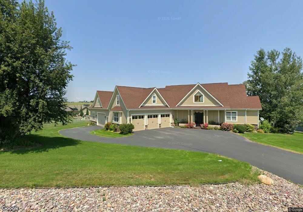
389 Stoneridge Dr Kalispell, MT 59901
Estimated Value: $903,000 - $969,000
4
Beds
4
Baths
3,845
Sq Ft
$245/Sq Ft
Est. Value
About This Home
This home is located at 389 Stoneridge Dr, Kalispell, MT 59901 and is currently estimated at $940,894, approximately $244 per square foot. 389 Stoneridge Dr is a home located in Flathead County with nearby schools including Lillian Peterson School, Kalispell Middle School, and Flathead High School.
Ownership History
Date
Name
Owned For
Owner Type
Purchase Details
Closed on
Dec 7, 2011
Sold by
Rourke Loren L and Satterfield Ronald S
Bought by
Peters Michael L and Peters Shianna L
Current Estimated Value
Home Financials for this Owner
Home Financials are based on the most recent Mortgage that was taken out on this home.
Original Mortgage
$399,400
Outstanding Balance
$273,872
Interest Rate
4.06%
Mortgage Type
VA
Estimated Equity
$667,022
Purchase Details
Closed on
Apr 16, 2007
Sold by
Fercho Construction Inc
Bought by
Rourke Loren L and Satterfield Ronald S
Home Financials for this Owner
Home Financials are based on the most recent Mortgage that was taken out on this home.
Original Mortgage
$524,000
Interest Rate
6.13%
Mortgage Type
New Conventional
Purchase Details
Closed on
Aug 16, 2005
Sold by
Willow Wind Development Inc
Bought by
Fercho Construction Inc
Create a Home Valuation Report for This Property
The Home Valuation Report is an in-depth analysis detailing your home's value as well as a comparison with similar homes in the area
Purchase History
| Date | Buyer | Sale Price | Title Company |
|---|---|---|---|
| Peters Michael L | -- | Insured Titles | |
| Rourke Loren L | -- | Citizens Title And Escrow Co | |
| Fercho Construction Inc | -- | Citizens Title And Escrow Co |
Source: Public Records
Mortgage History
| Date | Status | Borrower | Loan Amount |
|---|---|---|---|
| Open | Peters Michael L | $399,400 | |
| Previous Owner | Rourke Loren L | $524,000 |
Source: Public Records
Tax History
| Year | Tax Paid | Tax Assessment Tax Assessment Total Assessment is a certain percentage of the fair market value that is determined by local assessors to be the total taxable value of land and additions on the property. | Land | Improvement |
|---|---|---|---|---|
| 2025 | $4,611 | $1,014,000 | $0 | $0 |
| 2024 | $4,826 | $755,800 | $0 | $0 |
| 2023 | $4,818 | $755,800 | $0 | $0 |
| 2022 | $4,751 | $543,900 | $0 | $0 |
| 2021 | $4,802 | $543,900 | $0 | $0 |
| 2020 | $4,439 | $487,700 | $0 | $0 |
| 2019 | $4,445 | $487,700 | $0 | $0 |
| 2018 | $4,601 | $484,500 | $0 | $0 |
| 2017 | $4,622 | $484,500 | $0 | $0 |
| 2016 | $3,791 | $438,200 | $0 | $0 |
| 2015 | $3,854 | $438,200 | $0 | $0 |
| 2014 | $3,576 | $243,747 | $0 | $0 |
Source: Public Records
Map
Nearby Homes
- 605 Stoneridge Dr
- 125 Stoneridge Dr
- TBD Tbd
- 1381 Creekside Ct
- 152 Peaks View Loop
- 130 Lupine Dr
- 108 Eagle Crest Ct
- 1217 5th St W
- 192 Glacier Flats Rd
- 76 Meadow Mint Way
- 163 Greenbriar Dr
- 26 W View Dr
- 8 Primrose Ct
- 1000 W Idaho St
- 514 9th Ave W
- 539 Hun Ln
- 36 9th Ave W
- 819 9th Ave W
- 200 Aspen Loop
- 824 8th St W
- 29 Stoneridge Place
- 365 Stoneridge Dr
- 29 Stoneridge Place
- Lot 37 Stoneridge Subdivision
- 388 Stoneridge Dr
- Lot 13 Stoneridge Place
- Lot 14 Stoneridge Place
- 65 Stoneridge Place
- Lot 8 Stoneridge Place
- Lot 11 Stoneridge Place
- Lot 6 Stoneridge Subdivision
- 53 Stoneridge Place
- 368 Stoneridge Dr
- 341 Stoneridge Dr
- 462 Stoneridge Dr
- 16 Stoneridge Place
- 40 Stoneridge Place
- 437 Stoneridge Dr
- 0 Stoneridge Dr Unit 323189
- 0 Stoneridge Dr Unit 243402
Your Personal Tour Guide
Ask me questions while you tour the home.