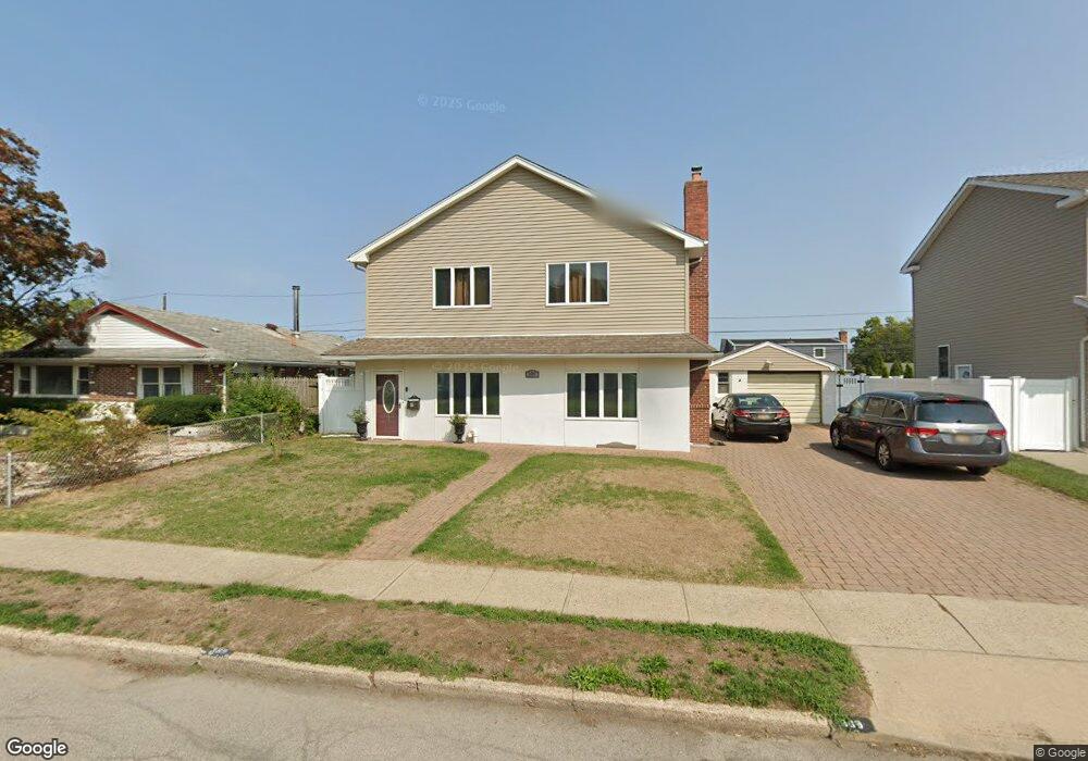
389 Sussex Rd East Meadow, NY 11554
Estimated Value: $896,239 - $945,000
6
Beds
2
Baths
2,752
Sq Ft
$335/Sq Ft
Est. Value
About This Home
This home is located at 389 Sussex Rd, East Meadow, NY 11554 and is currently estimated at $920,620, approximately $334 per square foot. 389 Sussex Rd is a home located in Nassau County with nearby schools including Parkway School and Woodland Middle School.
Ownership History
Date
Name
Owned For
Owner Type
Purchase Details
Closed on
Mar 27, 2015
Sold by
Martin Maureen and Martin Brad
Bought by
Barlow Michael and Barlow Swapna
Current Estimated Value
Home Financials for this Owner
Home Financials are based on the most recent Mortgage that was taken out on this home.
Original Mortgage
$428,000
Outstanding Balance
$329,841
Interest Rate
3.77%
Mortgage Type
Construction
Estimated Equity
$590,779
Purchase Details
Closed on
Apr 12, 2007
Sold by
Martin Brad
Purchase Details
Closed on
May 19, 2006
Sold by
Todaro Gary
Purchase Details
Closed on
Jun 26, 2002
Sold by
Todaro Gary
Purchase Details
Closed on
Feb 1, 2002
Create a Home Valuation Report for This Property
The Home Valuation Report is an in-depth analysis detailing your home's value as well as a comparison with similar homes in the area
Home Values in the Area
Average Home Value in this Area
Purchase History
| Date | Buyer | Sale Price | Title Company |
|---|---|---|---|
| Barlow Michael | $535,000 | First American Title | |
| -- | -- | -- | |
| -- | $610,000 | -- | |
| -- | -- | -- | |
| -- | $215,000 | -- |
Source: Public Records
Mortgage History
| Date | Status | Borrower | Loan Amount |
|---|---|---|---|
| Open | Barlow Michael | $428,000 |
Source: Public Records
Tax History Compared to Growth
Tax History
| Year | Tax Paid | Tax Assessment Tax Assessment Total Assessment is a certain percentage of the fair market value that is determined by local assessors to be the total taxable value of land and additions on the property. | Land | Improvement |
|---|---|---|---|---|
| 2025 | $13,962 | $581 | $249 | $332 |
| 2024 | $4,355 | $581 | $249 | $332 |
| 2023 | $13,429 | $581 | $249 | $332 |
| 2022 | $13,429 | $581 | $249 | $332 |
| 2021 | $18,323 | $565 | $242 | $323 |
| 2020 | $13,381 | $770 | $528 | $242 |
| 2019 | $12,813 | $825 | $566 | $259 |
| 2018 | $13,130 | $820 | $0 | $0 |
| 2017 | $8,073 | $820 | $468 | $352 |
| 2016 | $11,870 | $820 | $468 | $352 |
| 2015 | $4,145 | $1,012 | $577 | $435 |
| 2014 | $4,145 | $1,012 | $577 | $435 |
| 2013 | $3,875 | $1,012 | $577 | $435 |
Source: Public Records
Map
Nearby Homes
- 406 Wellington Rd
- 2573 7th Ave
- 2660 Woods Ave
- 360 Star St
- 2666 Lexington Ave
- 2619 Falcon St
- 2480 Fir Ct
- 2760 Cypress Ave
- 558 Kingston Ave
- 2586 1st Ave
- 2499 3rd Ave
- 583 Kingston Ave
- 2500 1st Ave
- 557 Newbridge Rd
- 552 Benton Rd
- 413 Robyn Place
- 2497 Tonquin St
- 2479 Tonquin St
- 646 Evelyn Ave
- 45 Shotgun Ln