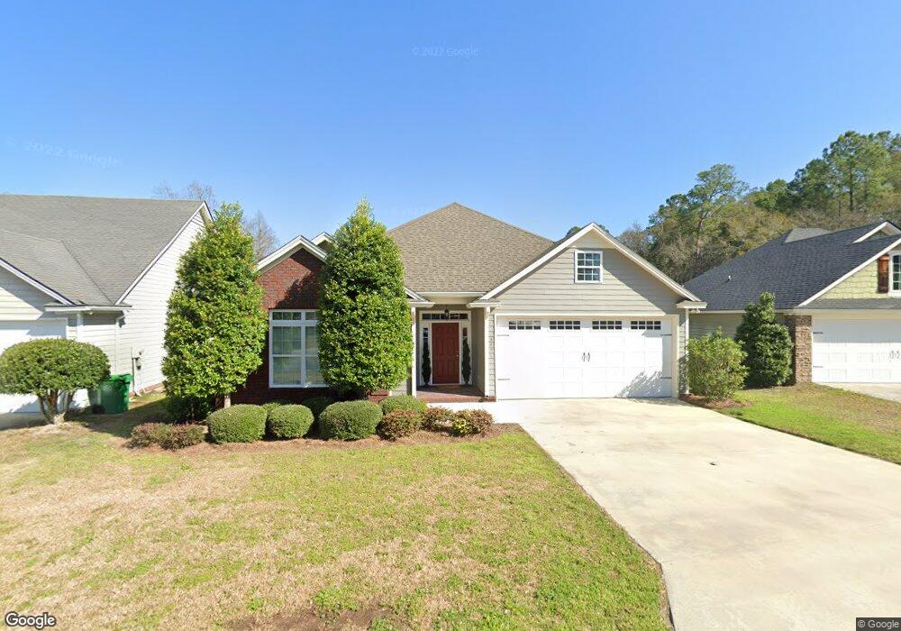
3891 Napa Dr Valdosta, GA 31605
Estimated Value: $241,000 - $252,000
3
Beds
2
Baths
1,764
Sq Ft
$139/Sq Ft
Est. Value
About This Home
This home is located at 3891 Napa Dr, Valdosta, GA 31605 and is currently estimated at $244,857, approximately $138 per square foot. 3891 Napa Dr is a home located in Lowndes County with nearby schools including Sallas Mahone Elementary School, Valdosta Middle School, and Valdosta High School.
Ownership History
Date
Name
Owned For
Owner Type
Purchase Details
Closed on
Jul 27, 2006
Sold by
Constructio Mclain and Constructio Brown
Bought by
Amendola Vickie
Current Estimated Value
Home Financials for this Owner
Home Financials are based on the most recent Mortgage that was taken out on this home.
Original Mortgage
$94,000
Outstanding Balance
$56,375
Interest Rate
6.74%
Mortgage Type
New Conventional
Estimated Equity
$188,482
Purchase Details
Closed on
Feb 15, 2006
Sold by
King & Watson Investments
Bought by
Mclain & Brown Construction Co
Purchase Details
Closed on
Jan 23, 2006
Sold by
Gtf Llc
Bought by
King & Watson Investment Grp I
Purchase Details
Closed on
Apr 21, 2005
Bought by
Gtf Llc
Create a Home Valuation Report for This Property
The Home Valuation Report is an in-depth analysis detailing your home's value as well as a comparison with similar homes in the area
Home Values in the Area
Average Home Value in this Area
Purchase History
| Date | Buyer | Sale Price | Title Company |
|---|---|---|---|
| Amendola Vickie | $195,000 | -- | |
| Mclain & Brown Construction Co | $41,000 | -- | |
| King & Watson Investment Grp I | $428,700 | -- | |
| Gtf Llc | -- | -- |
Source: Public Records
Mortgage History
| Date | Status | Borrower | Loan Amount |
|---|---|---|---|
| Open | Amendola Vickie | $94,000 |
Source: Public Records
Tax History Compared to Growth
Tax History
| Year | Tax Paid | Tax Assessment Tax Assessment Total Assessment is a certain percentage of the fair market value that is determined by local assessors to be the total taxable value of land and additions on the property. | Land | Improvement |
|---|---|---|---|---|
| 2024 | $2,324 | $89,208 | $8,800 | $80,408 |
| 2023 | $2,324 | $83,022 | $8,800 | $74,222 |
| 2022 | $2,147 | $69,546 | $8,800 | $60,746 |
| 2021 | $1,730 | $55,760 | $6,000 | $49,760 |
| 2020 | $1,767 | $55,760 | $6,000 | $49,760 |
| 2019 | $1,766 | $55,760 | $6,000 | $49,760 |
| 2018 | $0 | $55,760 | $6,000 | $49,760 |
| 2017 | $1,802 | $55,760 | $6,000 | $49,760 |
| 2016 | $1,799 | $55,760 | $6,000 | $49,760 |
| 2015 | -- | $55,760 | $6,000 | $49,760 |
| 2014 | $1,517 | $50,960 | $4,800 | $46,160 |
Source: Public Records
Map
Nearby Homes
- 4111 Oak Dr
- 5168 Greyfield Place S
- 3918 Camellia Dr
- 5026 Greyfield Place N
- 5006 Greyfield Place N
- 383 Camellia Dr
- 3480 Bemiss Rd
- 1.39 ac. Bemiss Rd
- 4475 Bemiss Rd
- 100 Starmount Dr
- 3448 Bemiss Rd
- 102 Starmount Dr
- 1 Dawnview Cir
- 3604 Bellhaven Dr
- 115 Brookview Terrace
- 3504 Breckland Dr
- 729 Lake Laurie Dr
- The Belfort Plan at Hawthorne North
- The Beau Plan at Hawthorne North
- The Ryleigh Plan at Hawthorne North