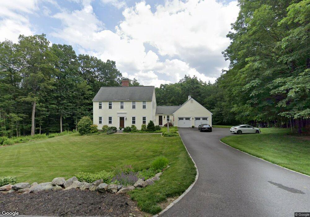
39 Bare Hill Rd Bolton, MA 01740
Estimated Value: $852,147 - $1,137,000
3
Beds
3
Baths
2,169
Sq Ft
$443/Sq Ft
Est. Value
About This Home
This home is located at 39 Bare Hill Rd, Bolton, MA 01740 and is currently estimated at $960,787, approximately $442 per square foot. 39 Bare Hill Rd is a home located in Worcester County with nearby schools including Florence Sawyer School, Nashoba Regional High School, and Immaculate Heart of Mary School.
Ownership History
Date
Name
Owned For
Owner Type
Purchase Details
Closed on
Aug 15, 2000
Sold by
Wells David S and Wells Kristin M
Bought by
Bogert William E and Bogert Katherine F
Current Estimated Value
Purchase Details
Closed on
Sep 25, 1998
Sold by
Bare Hill Road Rt and Woodruff Jay
Bought by
Liberty Tree Rt and Augustine Joseph D
Create a Home Valuation Report for This Property
The Home Valuation Report is an in-depth analysis detailing your home's value as well as a comparison with similar homes in the area
Home Values in the Area
Average Home Value in this Area
Purchase History
| Date | Buyer | Sale Price | Title Company |
|---|---|---|---|
| Bogert William E | $432,000 | -- | |
| Liberty Tree Rt | $151,500 | -- |
Source: Public Records
Mortgage History
| Date | Status | Borrower | Loan Amount |
|---|---|---|---|
| Open | Liberty Tree Rt | $325,000 | |
| Closed | Liberty Tree Rt | $358,000 |
Source: Public Records
Tax History Compared to Growth
Tax History
| Year | Tax Paid | Tax Assessment Tax Assessment Total Assessment is a certain percentage of the fair market value that is determined by local assessors to be the total taxable value of land and additions on the property. | Land | Improvement |
|---|---|---|---|---|
| 2025 | $12,096 | $727,800 | $219,100 | $508,700 |
| 2024 | $11,754 | $722,900 | $209,000 | $513,900 |
| 2023 | $11,333 | $647,600 | $204,000 | $443,600 |
| 2022 | $10,134 | $510,000 | $184,000 | $326,000 |
| 2021 | $10,115 | $484,900 | $184,000 | $300,900 |
| 2020 | $9,526 | $467,200 | $184,000 | $283,200 |
| 2019 | $9,291 | $453,900 | $184,000 | $269,900 |
| 2018 | $9,303 | $450,300 | $179,000 | $271,300 |
| 2017 | $9,050 | $426,900 | $174,000 | $252,900 |
| 2016 | $8,607 | $411,600 | $159,100 | $252,500 |
| 2015 | $8,671 | $413,300 | $164,100 | $249,200 |
| 2014 | $8,603 | $405,800 | $169,100 | $236,700 |
Source: Public Records
Map
Nearby Homes
- 347 Green Rd
- 68 Old Harvard Rd
- 3 Old Harvard Rd
- 291 Harvard Rd
- 231 Vaughn Hill Rd
- 90 Harvard Rd
- 236 Bolton Rd
- 159 W Bare Hill Rd
- 114 Fox Run Rd
- 285 Still River Rd
- 2 Green Rd
- 3 Pondside Ln Unit 3
- 11 Pondside Ln Unit 11
- 871 Main St
- 1 Green Rd
- 22 Kettle Hole Rd
- 21 Woodside Rd
- 23 Harvard Rd
- 1A Sanders Ln
- 6A Sanders Ln