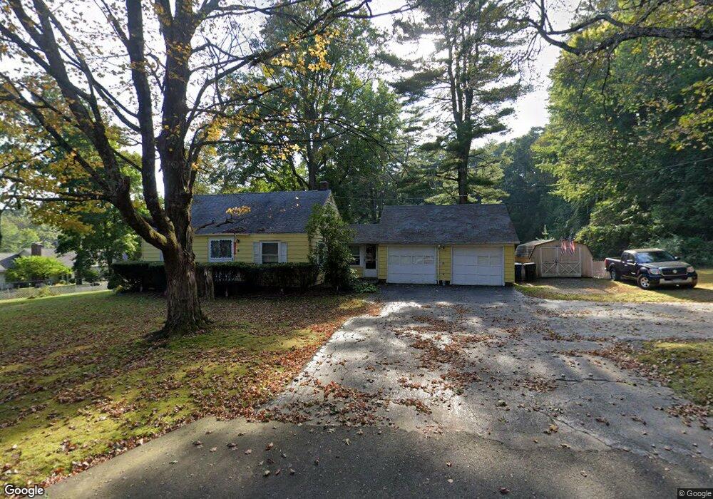
39 Buff Cap Rd Tolland, CT 06084
Estimated Value: $310,000 - $368,000
3
Beds
2
Baths
1,092
Sq Ft
$303/Sq Ft
Est. Value
About This Home
This home is located at 39 Buff Cap Rd, Tolland, CT 06084 and is currently estimated at $330,348, approximately $302 per square foot. 39 Buff Cap Rd is a home located in Tolland County with nearby schools including Tolland High School.
Ownership History
Date
Name
Owned For
Owner Type
Purchase Details
Closed on
Jan 19, 2000
Sold by
Burke Thomas and Burke Jennifr
Bought by
Young Timothy and Young Teresa
Current Estimated Value
Purchase Details
Closed on
Sep 30, 1997
Sold by
Shirsac Waltraut
Bought by
Burke Thomas and Burke Jennifer
Create a Home Valuation Report for This Property
The Home Valuation Report is an in-depth analysis detailing your home's value as well as a comparison with similar homes in the area
Home Values in the Area
Average Home Value in this Area
Purchase History
| Date | Buyer | Sale Price | Title Company |
|---|---|---|---|
| Young Timothy | $124,000 | -- | |
| Young Timothy | $124,000 | -- | |
| Burke Thomas | $112,000 | -- | |
| Burke Thomas | $112,000 | -- |
Source: Public Records
Mortgage History
| Date | Status | Borrower | Loan Amount |
|---|---|---|---|
| Open | Burke Thomas | $45,400 | |
| Closed | Burke Thomas | $40,000 |
Source: Public Records
Tax History
| Year | Tax Paid | Tax Assessment Tax Assessment Total Assessment is a certain percentage of the fair market value that is determined by local assessors to be the total taxable value of land and additions on the property. | Land | Improvement |
|---|---|---|---|---|
| 2025 | $5,169 | $190,100 | $73,400 | $116,700 |
| 2024 | $5,125 | $135,700 | $70,200 | $65,500 |
| 2023 | $5,066 | $135,700 | $70,200 | $65,500 |
| 2022 | $4,964 | $135,700 | $70,200 | $65,500 |
| 2021 | $5,036 | $135,700 | $70,200 | $65,500 |
| 2020 | $4,892 | $135,700 | $70,200 | $65,500 |
| 2019 | $4,755 | $131,900 | $72,300 | $59,600 |
| 2018 | $4,617 | $131,900 | $72,300 | $59,600 |
| 2017 | $4,510 | $131,900 | $72,300 | $59,600 |
| 2016 | $4,510 | $131,900 | $72,300 | $59,600 |
| 2015 | $4,400 | $131,900 | $72,300 | $59,600 |
| 2014 | $4,266 | $137,400 | $79,800 | $57,600 |
Source: Public Records
Map
Nearby Homes
- 0 Tolland Stage Rd Unit 24101836
- 0 River Rd Unit 24120753
- 487 Buff Cap Rd
- 159 Anthony Rd
- 137 Anthony Rd
- 27 Amanda Way
- 33 Josephine Way
- 25 Josephine Way
- 131 River Rd
- 41 Neff Hill Rd
- 8 Neff Hill Rd
- 124 River Rd
- 71 Neff Hill Rd
- 110 Neff Hill Rd
- 105 Neff Hill Rd
- 137 Neff Hill Rd
- 77 Neff Hill Rd
- 100 Neff Hill Rd
- 84 Neff Hill Rd
- 15 Usher Ridge
- 7 N River Rd
- 55 Buff Cap Rd
- 26 N River Rd
- 44 Buff Cap Rd
- 12 N River Rd
- 15 N River Rd Unit 1
- 15 N River Rd Unit 11
- 63 Buff Cap Rd
- 58 Buff Cap Rd
- 2 N River Rd
- 3 N River Rd
- 1415 Tolland Stage Rd
- 1399 Tolland Stage Rd
- 72 Buff Cap Rd
- 71 Buff Cap Rd
- 1408 Tolland Stage Rd
- 80 Buff Cap Rd
- 83 Buff Cap Rd
- 1385 Tolland Stage Rd
- 87 Buff Cap Rd
Your Personal Tour Guide
Ask me questions while you tour the home.