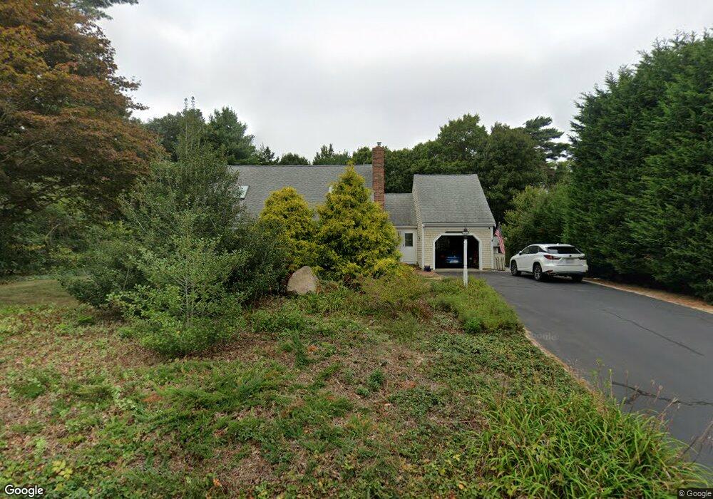
39 Corrine Dr East Falmouth, MA 02536
Hatchville NeighborhoodEstimated Value: $653,000 - $805,000
2
Beds
1
Bath
988
Sq Ft
$735/Sq Ft
Est. Value
About This Home
This home is located at 39 Corrine Dr, East Falmouth, MA 02536 and is currently estimated at $726,075, approximately $734 per square foot. 39 Corrine Dr is a home located in Barnstable County with nearby schools including Mullen-Hall School, Morse Pond School, and Lawrence School.
Ownership History
Date
Name
Owned For
Owner Type
Purchase Details
Closed on
Oct 7, 2024
Sold by
Nickerson Alvan L and Nickerson Barbara H
Bought by
Aln Bhn 2024 Rt and Nickerson
Current Estimated Value
Purchase Details
Closed on
Oct 8, 1985
Bought by
Nickerson Alvan L and Nickerson Barbara N
Create a Home Valuation Report for This Property
The Home Valuation Report is an in-depth analysis detailing your home's value as well as a comparison with similar homes in the area
Home Values in the Area
Average Home Value in this Area
Purchase History
| Date | Buyer | Sale Price | Title Company |
|---|---|---|---|
| Aln Bhn 2024 Rt | -- | None Available | |
| Aln Bhn 2024 Rt | -- | None Available | |
| Aln Bhn 2024 Rt | -- | None Available | |
| Nickerson Alvan L | $31,500 | -- |
Source: Public Records
Mortgage History
| Date | Status | Borrower | Loan Amount |
|---|---|---|---|
| Previous Owner | Nickerson Alvan L | $70,965 | |
| Previous Owner | Nickerson Alvan L | $90,000 | |
| Previous Owner | Nickerson Alvan L | $102,000 |
Source: Public Records
Tax History Compared to Growth
Tax History
| Year | Tax Paid | Tax Assessment Tax Assessment Total Assessment is a certain percentage of the fair market value that is determined by local assessors to be the total taxable value of land and additions on the property. | Land | Improvement |
|---|---|---|---|---|
| 2025 | $3,686 | $627,900 | $215,700 | $412,200 |
| 2024 | $3,647 | $580,800 | $204,700 | $376,100 |
| 2023 | $3,156 | $456,100 | $165,300 | $290,800 |
| 2022 | $3,058 | $379,900 | $138,700 | $241,200 |
| 2021 | $2,871 | $337,800 | $127,100 | $210,700 |
| 2020 | $2,803 | $326,300 | $115,600 | $210,700 |
| 2019 | $2,747 | $320,900 | $115,600 | $205,300 |
| 2018 | $2,707 | $314,800 | $115,600 | $199,200 |
| 2017 | $2,619 | $307,000 | $115,600 | $191,400 |
| 2016 | $2,570 | $307,000 | $115,600 | $191,400 |
| 2015 | $2,514 | $307,000 | $115,600 | $191,400 |
| 2014 | $2,540 | $311,600 | $121,700 | $189,900 |
Source: Public Records
Map
Nearby Homes
- 590 Sandwich Rd
- 68 Deepwood Dr
- 25 Harris Hill Rd
- 17 Pinewood Dr
- 59 Whitecaps Dr
- 70 Meredith Dr
- 100 Tanglewood Dr
- 12 Rock Hollow Dr
- 66 Braxton Rd
- 3 Viber Ln
- 32 Jamie Ln
- 273 Sandwich Rd
- 130 Old Barnstable Rd
- 149 Brick Kiln Rd
- 809 Sandwich Rd
- 33 John Parker Rd
- 35 Old Barnstable Rd
- 23 Little John Rd
- 24 Little John Rd
- 35 Corrine Dr
- 29 Pine Cone Ln
- 18 Cold Spring Ln
- 34 Corrine Dr
- 29 Corrine Dr
- 24 Pine Cone Ln
- 30 Pine Cone Ln
- 14 Cold Spring Ln
- 100 Lake Shore Dr
- 0 Cold Spring Ln
- 18 Pine Cone Ln
- 102 Lake Shore Dr
- 26 Corrine Dr
- 25 Corrine Dr
- 5 Pine Cone Ln
- 94 Lake Shore Dr
- 96 Lake Shore Dr
- 104 Lake Shore Dr
- 12 Cold Spring Ln
- 92 Lake Shore Dr