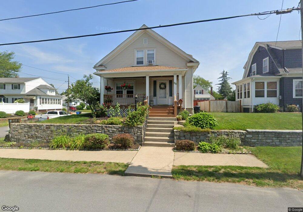
39 Davis Ave Cranston, RI 02910
Eden Park NeighborhoodEstimated Value: $402,941 - $443,000
3
Beds
2
Baths
1,326
Sq Ft
$324/Sq Ft
Est. Value
About This Home
This home is located at 39 Davis Ave, Cranston, RI 02910 and is currently estimated at $428,985, approximately $323 per square foot. 39 Davis Ave is a home located in Providence County with nearby schools including Park View Middle School, Cranston High School East, and Cadence Academy Preschool - Cranston.
Ownership History
Date
Name
Owned For
Owner Type
Purchase Details
Closed on
Jan 14, 2025
Sold by
Butts Maria C and Calvino Anna R
Bought by
Calvino Anna R and Calvino Alfred N
Current Estimated Value
Purchase Details
Closed on
Jun 21, 2018
Sold by
Corisni-Butts Maria
Bought by
Corisni-Butts Maria and Calvino Anna R
Create a Home Valuation Report for This Property
The Home Valuation Report is an in-depth analysis detailing your home's value as well as a comparison with similar homes in the area
Home Values in the Area
Average Home Value in this Area
Purchase History
| Date | Buyer | Sale Price | Title Company |
|---|---|---|---|
| Calvino Anna R | -- | None Available | |
| Calvino Anna R | -- | None Available | |
| Calvino Anna R | -- | None Available | |
| Corisni-Butts Maria | -- | -- | |
| Corisni-Butts Maria | -- | -- |
Source: Public Records
Mortgage History
| Date | Status | Borrower | Loan Amount |
|---|---|---|---|
| Previous Owner | Corisni-Butts Maria | $144,000 | |
| Previous Owner | Corisni-Butts Maria | $100,000 | |
| Previous Owner | Corisni-Butts Maria | $25,000 |
Source: Public Records
Tax History
| Year | Tax Paid | Tax Assessment Tax Assessment Total Assessment is a certain percentage of the fair market value that is determined by local assessors to be the total taxable value of land and additions on the property. | Land | Improvement |
|---|---|---|---|---|
| 2025 | $4,614 | $332,400 | $104,400 | $228,000 |
| 2024 | $4,524 | $332,400 | $104,400 | $228,000 |
| 2023 | $4,164 | $220,300 | $68,700 | $151,600 |
| 2022 | $4,078 | $220,300 | $68,700 | $151,600 |
| 2021 | $3,965 | $220,300 | $68,700 | $151,600 |
| 2020 | $3,865 | $186,100 | $65,500 | $120,600 |
| 2019 | $3,865 | $186,100 | $65,500 | $120,600 |
| 2018 | $3,776 | $186,100 | $65,500 | $120,600 |
| 2017 | $3,670 | $160,000 | $58,900 | $101,100 |
| 2016 | $3,592 | $160,000 | $58,900 | $101,100 |
| 2015 | $3,592 | $160,000 | $58,900 | $101,100 |
| 2014 | $3,584 | $156,900 | $58,900 | $98,000 |
Source: Public Records
Map
Nearby Homes
Your Personal Tour Guide
Ask me questions while you tour the home.