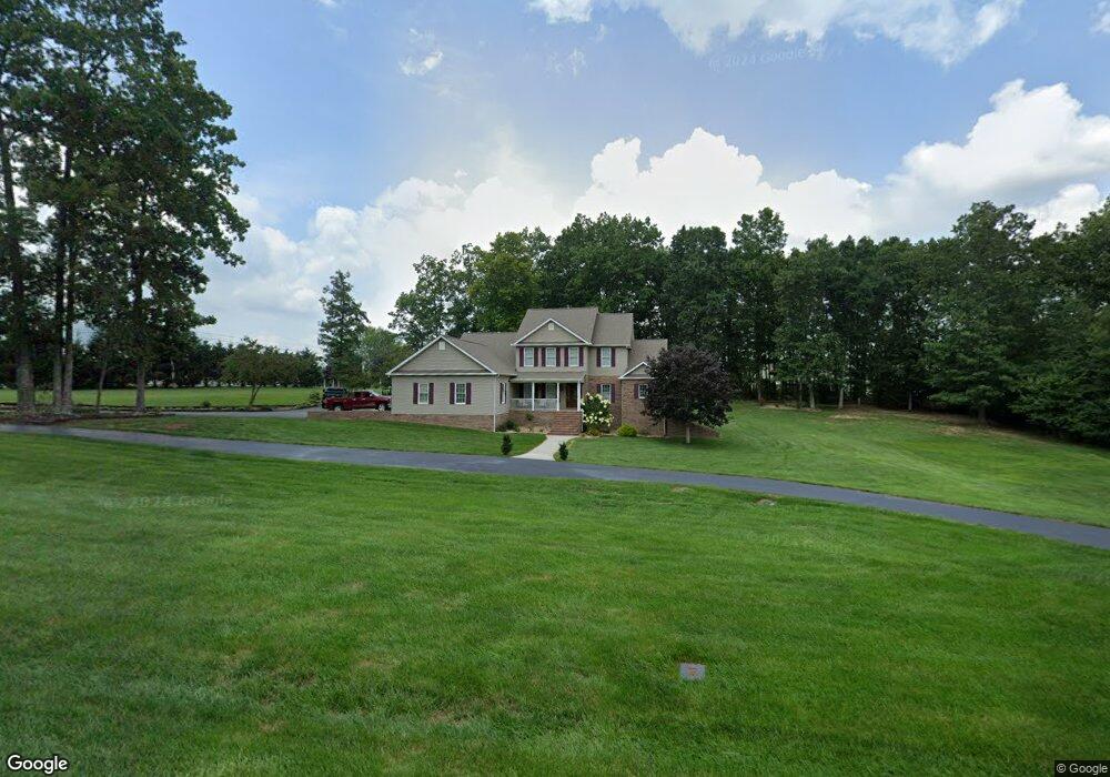
39 Graham Cir Crossville, TN 38555
Estimated Value: $713,000 - $796,797
4
Beds
4
Baths
4,476
Sq Ft
$169/Sq Ft
Est. Value
About This Home
This home is located at 39 Graham Cir, Crossville, TN 38555 and is currently estimated at $757,949, approximately $169 per square foot. 39 Graham Cir is a home located in Cumberland County with nearby schools including South Cumberland Elementary School and Cumberland County High School.
Ownership History
Date
Name
Owned For
Owner Type
Purchase Details
Closed on
Mar 3, 2020
Sold by
Graham D Michael D and Graham Janet C
Bought by
Brown Bobby A and Brown Laura E
Current Estimated Value
Home Financials for this Owner
Home Financials are based on the most recent Mortgage that was taken out on this home.
Original Mortgage
$435,120
Outstanding Balance
$383,621
Interest Rate
3.6%
Mortgage Type
VA
Estimated Equity
$374,328
Purchase Details
Closed on
Nov 21, 1995
Sold by
Michael Graham D
Bought by
Michael Graham D
Purchase Details
Closed on
Nov 1, 1995
Bought by
Graham D Michael D and Graham Janet C
Purchase Details
Closed on
Jan 3, 1992
Bought by
Goodwin J T Sr Management Trust
Create a Home Valuation Report for This Property
The Home Valuation Report is an in-depth analysis detailing your home's value as well as a comparison with similar homes in the area
Home Values in the Area
Average Home Value in this Area
Purchase History
| Date | Buyer | Sale Price | Title Company |
|---|---|---|---|
| Brown Bobby A | $420,000 | Looney & Chadwell Title Svcs | |
| Michael Graham D | $9,825 | -- | |
| Graham D Michael D | $9,800 | -- | |
| Goodwin J T Sr Management Trust | $5,000 | -- |
Source: Public Records
Mortgage History
| Date | Status | Borrower | Loan Amount |
|---|---|---|---|
| Open | Brown Bobby A | $435,120 |
Source: Public Records
Tax History Compared to Growth
Tax History
| Year | Tax Paid | Tax Assessment Tax Assessment Total Assessment is a certain percentage of the fair market value that is determined by local assessors to be the total taxable value of land and additions on the property. | Land | Improvement |
|---|---|---|---|---|
| 2025 | $1,488 | $131,075 | $10,500 | $120,575 |
| 2024 | $1,488 | $131,075 | $10,500 | $120,575 |
| 2023 | $1,488 | $131,075 | $0 | $0 |
| 2022 | $1,488 | $131,075 | $10,500 | $120,575 |
| 2021 | $1,289 | $82,375 | $7,000 | $75,375 |
| 2020 | $1,289 | $82,375 | $7,000 | $75,375 |
| 2019 | $1,289 | $82,375 | $7,000 | $75,375 |
| 2018 | $1,289 | $82,375 | $7,000 | $75,375 |
| 2017 | $1,289 | $82,375 | $7,000 | $75,375 |
| 2016 | $1,267 | $82,975 | $7,000 | $75,975 |
| 2015 | $1,243 | $82,975 | $7,000 | $75,975 |
| 2014 | $1,242 | $82,971 | $0 | $0 |
Source: Public Records
Map
Nearby Homes
- 566 Martin Rd
- 5.66 AC Martin Rd
- 370 Red Brush Dr
- 159 N Victor Way
- 0 Quail Ridge Dr Unit 1314965
- 125 Cedar Ridge Ln
- 0 Sparta Hwy 31 64 + - Acres
- 0 Sparta Hwy 31 65 + - Acres
- 3571 Sparta Hwy Unit 3571
- 0
- Lot 2 Tennessee Ave
- Lot 3 Tennessee Ave
- 0 Tennessee Ave Unit RTC2975371
- 0 Tennessee Ave Unit 1274553
- 42 Forest Crossover
- 53 Broadleaf Place
- 194 River Run Dr
- 484 River Bend Dr
- 484 River Bend Dr Unit c-5
- 0 Spruce Loop Unit 1257329
- 120 Graham Cir
- 24 Red Brush Dr
- 296 Martin Rd
- 0 Graham Dr
- 42 Graham Dr
- 375 Martin Rd
- 375 Martin Rd
- 86 Graham Cir
- 262 Martin Rd
- 100 Graham Dr
- 41 Graham Dr
- 192 Martin Rd
- 0 Red Brush Dr Unit 747888
- 0 Red Brush Dr Unit 928408
- 0 Red Brush Dr Unit 843003
- 398 Martin Rd
- Lot 37 Waukesha Dr
- Lot 38 Waukesha Dr
- Lot 39 Waukesha Dr
- 81 Waukesha Dr