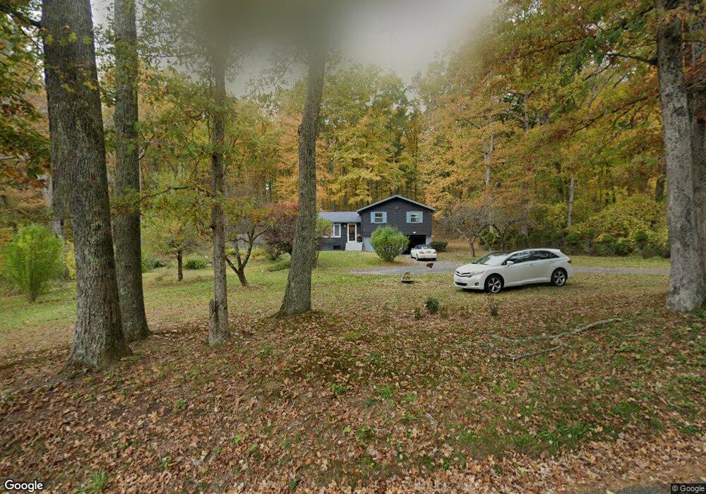
39 Larned Rd Oxford, MA 01540
Estimated Value: $398,000 - $445,000
3
Beds
1
Bath
1,000
Sq Ft
$424/Sq Ft
Est. Value
About This Home
This home is located at 39 Larned Rd, Oxford, MA 01540 and is currently estimated at $424,063, approximately $424 per square foot. 39 Larned Rd is a home located in Worcester County with nearby schools including Alfred M Chaffee, Oxford High School, and Clara Barton Elementary School.
Ownership History
Date
Name
Owned For
Owner Type
Purchase Details
Closed on
Apr 25, 2019
Sold by
Kubicki Allen
Bought by
Vincequere Deborah A
Current Estimated Value
Purchase Details
Closed on
Jun 1, 1971
Bought by
Kubicki Allen and Kubicki Dorothy M
Create a Home Valuation Report for This Property
The Home Valuation Report is an in-depth analysis detailing your home's value as well as a comparison with similar homes in the area
Home Values in the Area
Average Home Value in this Area
Purchase History
| Date | Buyer | Sale Price | Title Company |
|---|---|---|---|
| Vincequere Deborah A | -- | -- | |
| Kubicki Allen | -- | -- |
Source: Public Records
Mortgage History
| Date | Status | Borrower | Loan Amount |
|---|---|---|---|
| Previous Owner | Kubicki Allen | $100,000 | |
| Previous Owner | Kubicki Allen | $70,000 |
Source: Public Records
Tax History Compared to Growth
Tax History
| Year | Tax Paid | Tax Assessment Tax Assessment Total Assessment is a certain percentage of the fair market value that is determined by local assessors to be the total taxable value of land and additions on the property. | Land | Improvement |
|---|---|---|---|---|
| 2025 | $46 | $363,000 | $119,200 | $243,800 |
| 2024 | $4,318 | $320,300 | $110,100 | $210,200 |
| 2023 | $4,208 | $308,500 | $98,300 | $210,200 |
| 2022 | $3,626 | $224,400 | $70,800 | $153,600 |
| 2021 | $3,536 | $213,900 | $67,200 | $146,700 |
| 2020 | $3,419 | $205,200 | $67,200 | $138,000 |
| 2019 | $3,290 | $193,200 | $67,200 | $126,000 |
| 2018 | $3,148 | $182,300 | $67,200 | $115,100 |
| 2017 | $3,144 | $186,600 | $67,200 | $119,400 |
| 2016 | $3,159 | $186,600 | $67,200 | $119,400 |
| 2015 | $2,946 | $186,600 | $67,200 | $119,400 |
| 2014 | $2,885 | $192,300 | $67,200 | $125,100 |
Source: Public Records
Map
Nearby Homes
- 62 Larned Rd
- 28 Holly St
- 24 Linwood St
- 9 Nottingham Rd
- 32 Carron Ln
- 13 Tanner Rd
- 137 Main St
- 1 Hemlock St
- 0 Hayden Pond Rd
- 53 Bigelow Rd
- 36 Locust St
- 45 Cudworth Rd
- 6 Carol Dr
- 58 Lelandville Rd
- Lots 1+16 Pierpont Rd
- 124 Charlton St Unit F
- 4 Toria Heights Rd
- 177-179 N Main St
- 30 Noble St
- 44 Camile Rd