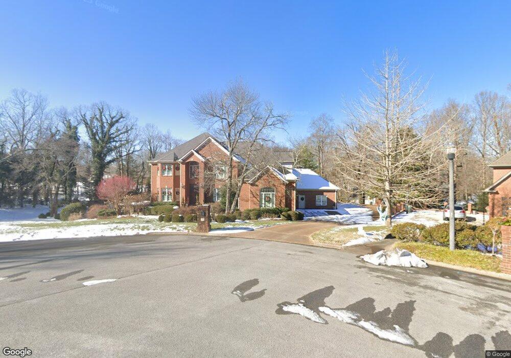
39 Mountain Orchard Path Signal Mountain, TN 37377
Estimated Value: $1,200,000 - $1,348,000
--
Bed
1
Bath
5,242
Sq Ft
$247/Sq Ft
Est. Value
About This Home
This home is located at 39 Mountain Orchard Path, Signal Mountain, TN 37377 and is currently estimated at $1,293,551, approximately $246 per square foot. 39 Mountain Orchard Path is a home located in Hamilton County with nearby schools including Thrasher Elementary School, Signal Mountain Middle/High School, and Signal Mountain Christian School.
Ownership History
Date
Name
Owned For
Owner Type
Purchase Details
Closed on
Apr 17, 2001
Sold by
Orchard Inc The
Bought by
Depasquale Stephen E and Depasquale Lisa
Current Estimated Value
Home Financials for this Owner
Home Financials are based on the most recent Mortgage that was taken out on this home.
Original Mortgage
$535,000
Interest Rate
6.99%
Create a Home Valuation Report for This Property
The Home Valuation Report is an in-depth analysis detailing your home's value as well as a comparison with similar homes in the area
Home Values in the Area
Average Home Value in this Area
Purchase History
| Date | Buyer | Sale Price | Title Company |
|---|---|---|---|
| Depasquale Stephen E | $41,000 | Pioneer Title Agency Inc |
Source: Public Records
Mortgage History
| Date | Status | Borrower | Loan Amount |
|---|---|---|---|
| Previous Owner | Depasquale Stephen E | $535,000 |
Source: Public Records
Tax History Compared to Growth
Tax History
| Year | Tax Paid | Tax Assessment Tax Assessment Total Assessment is a certain percentage of the fair market value that is determined by local assessors to be the total taxable value of land and additions on the property. | Land | Improvement |
|---|---|---|---|---|
| 2024 | $5,056 | $226,000 | $0 | $0 |
| 2023 | $5,056 | $226,000 | $0 | $0 |
| 2022 | $5,056 | $226,000 | $0 | $0 |
| 2021 | $5,056 | $226,000 | $0 | $0 |
| 2020 | $6,718 | $242,950 | $0 | $0 |
| 2019 | $6,718 | $242,950 | $0 | $0 |
| 2018 | $6,718 | $242,950 | $0 | $0 |
| 2017 | $6,718 | $242,950 | $0 | $0 |
| 2016 | $5,982 | $0 | $0 | $0 |
| 2015 | $5,982 | $216,325 | $0 | $0 |
| 2014 | $5,982 | $0 | $0 | $0 |
Source: Public Records
Map
Nearby Homes
- 11 Saint Nicholas Way
- 12 Mountain Orchard Path
- 10 Majestic Oaks Dr
- 0 Majestic Oaks Dr Unit 24033570
- 10 Acres Majestic Oaks Dr
- 25 Ridgerock Dr
- 0 Skyline Park Dr Unit 1525124
- 837 Skyline Park Dr
- 848 Skyline Park Dr
- 714 Berry Spring Path
- 1713 Timesville Rd
- 16 Northfield Rd
- 1702 James Blvd
- 3612 Taft Hwy
- 5734 U S 127
- 2598 Bristlecone Ln
- 2929 Battles Way
- 5025 Dandelion Trail
- 1305 E Brow Rd
- 1301 E Brow Rd
- 2 Ridgerock Dr
- 36 Mountain Orchard Path
- 37 Mountain Orchard Path
- 34 Mountain Orchard Path
- 34 Mtn Orchard Path
- 4 Ridgerock Dr
- 30 Mountain Orchard Path
- 35 Mountain Orchard Path
- 6 Ridgerock Dr
- 1232 Mountain Brook Cir
- 28 Mountain Orchard Path
- 3 Ridgerock Dr
- 1230 Mountain Brook Cir
- 898 Danbury Cove Place
- 8 Ridgerock Dr
- 31 Mountain Orchard Path
- 26 Mountain Orchard Path
- 5 Ridgerock Dr
- 892 Danbury Cove Place
- 4 Rock Haven Ln