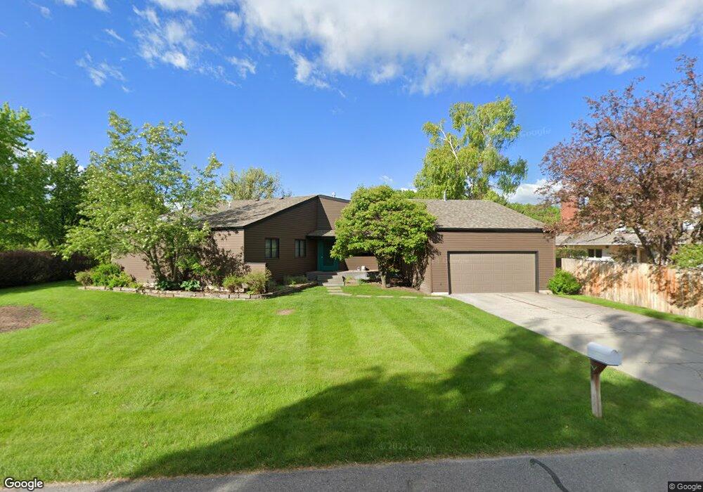
39 Riverside Dr Bozeman, MT 59715
North Bozeman NeighborhoodEstimated Value: $1,129,000 - $1,319,000
3
Beds
3
Baths
3,434
Sq Ft
$361/Sq Ft
Est. Value
About This Home
This home is located at 39 Riverside Dr, Bozeman, MT 59715 and is currently estimated at $1,239,494, approximately $360 per square foot. 39 Riverside Dr is a home located in Gallatin County with nearby schools including Hawthorne Elementary School, Chief Joseph Middle School, and Gallatin High School.
Ownership History
Date
Name
Owned For
Owner Type
Purchase Details
Closed on
Jan 24, 2017
Sold by
Sisson Gary Allen and Sisson Carole Jean Mcdonald
Bought by
Wenger James M and Wenger Lynda K
Current Estimated Value
Home Financials for this Owner
Home Financials are based on the most recent Mortgage that was taken out on this home.
Original Mortgage
$234,600
Outstanding Balance
$115,675
Interest Rate
4.16%
Mortgage Type
New Conventional
Estimated Equity
$1,123,819
Create a Home Valuation Report for This Property
The Home Valuation Report is an in-depth analysis detailing your home's value as well as a comparison with similar homes in the area
Home Values in the Area
Average Home Value in this Area
Purchase History
| Date | Buyer | Sale Price | Title Company |
|---|---|---|---|
| Wenger James M | -- | American Land Title Company |
Source: Public Records
Mortgage History
| Date | Status | Borrower | Loan Amount |
|---|---|---|---|
| Open | Wenger James M | $234,600 |
Source: Public Records
Tax History
| Year | Tax Paid | Tax Assessment Tax Assessment Total Assessment is a certain percentage of the fair market value that is determined by local assessors to be the total taxable value of land and additions on the property. | Land | Improvement |
|---|---|---|---|---|
| 2025 | $5,662 | $1,137,800 | $0 | $0 |
| 2024 | $9,031 | $1,356,600 | $0 | $0 |
| 2023 | $10,527 | $1,460,600 | $0 | $0 |
| 2022 | $5,204 | $780,780 | $0 | $0 |
| 2021 | $6,352 | $780,780 | $0 | $0 |
| 2020 | $5,938 | $707,500 | $0 | $0 |
| 2019 | $6,096 | $707,500 | $0 | $0 |
| 2018 | $5,953 | $627,899 | $0 | $0 |
| 2017 | $5,537 | $627,899 | $0 | $0 |
| 2016 | $4,914 | $516,038 | $0 | $0 |
| 2015 | $4,878 | $516,038 | $0 | $0 |
| 2014 | $5,790 | $376,449 | $0 | $0 |
Source: Public Records
Map
Nearby Homes
- 25 Riverside Dr
- NHN Springhill Rd
- 3646 N 27th Ave
- 263 Nelson Rd
- TBD Prince Ln
- TBD Royal Wolf Way
- 3380 Prince Ln
- 3481 Royal Wolf Way Unit B
- 3481 Royal Wolf Way Unit A
- 65 Naya-Nuki Dr
- 3341 N 27th Ave Unit 26
- 3555 Royal Wolf Way Unit Lot 18
- 3589 Royal Wolf Way Unit A
- 510 Cold Smoke
- 94 Snowcat Dr
- 27737 Frontage Rd
- 685 Naya Nuki Dr
- 3210 Warbler Way Unit 8
- 3206 Warbler Way Unit 11
- TBD Catamount & Davis
- 39 Riverside Dr
- 111 Gallatin Dr Unit A
- 111 Gallatin Dr Unit B
- 111 Gallatin Dr Unit A
- 111 Gallatin Dr
- 38 Riverside Dr
- 40 Riverside Dr
- 17 Riverside Dr
- 18 Riverside Dr
- 37 Riverside Dr
- 41 Riverside Dr
- 19 Riverside Dr
- 19 Riverside Dr
- 15 Riverside Dr
- 42 Riverside Dr
- 36 Riverside Dr
- 20 Riverside Dr
- 35 Riverside Dr
- 43 Riverside Dr
- 14 Park Plaza Rd
Your Personal Tour Guide
Ask me questions while you tour the home.